Geology in the desert of Atacama
Sentinel-2 MSI acquired on 09 April 2017 at 14:37:51 UTC
Sentinel-1 CSAR IW acquired on 26 May 2017 from 23:05:02 to 23:05:52 UTC
Sentinel-1 CSAR IW acquired on 26 May 2017 from 23:05:02 to 23:05:52 UTC
Keyword(s): Land, mountains, geology, subduction, faults, volcanoes, salar, alluvial fans, Bolivia, Chile, Argentina, Andes range, Cordillera, Atacama desert, Altiplano
Pr. Jean Chorowicz, emeritus Professor at Sorbonne Universités, UPMC Univ Paris 06 commented the three Sentinel-1B CSAR scenes. "They concern a segment of the Andes where the climate is hyperarid in the west, including the Atacama desert, and wet in the east. A cold water coastal current chills the surface water of the Pacific Ocean reducing the advection of Pacific water vapor inland. Hyperaridity started at ca.12 Ma with the growth of the Andes Mountains that serve as an orographic barrier against water vapor coming from the east.
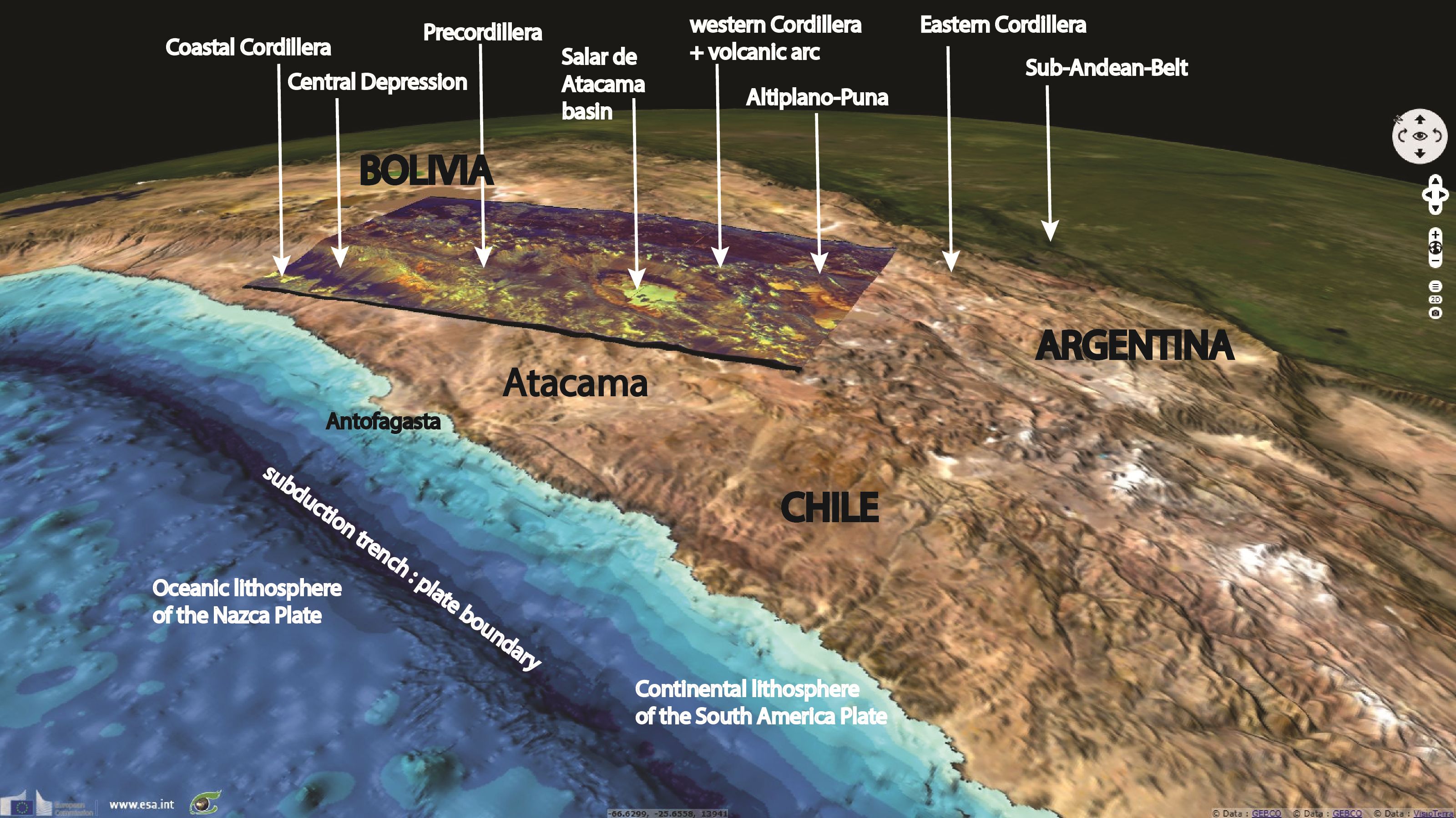
The region is one of the most active plate boundaries in the world where the still ongoing relative convergence between the Nazca and the South American plates is directed N78°E at a very fast speed of 68–80 mm/yr. The Nazca plate oceanic lithosphere (oceanic crust + lithospheric mantle) is subducting eastward underneath the South America plate continental lithosphere (continental crust + lithospheric mantle). If most of the relative motion occurs along the subduction contact at bottom of the Peru-Chile trench, it is clear that differential movement and related deformation also affect the margin of the South America plate producing the wide (750 km) deformation belt of the Andes, one of the world's major mountain ranges (more than 8000 km in length). The Andes are characterized by a succession of north-south trending mountain ranges and basins. An active volcanic arc forms the Western Cordillera at the western border of the Altiplano-Puna range."
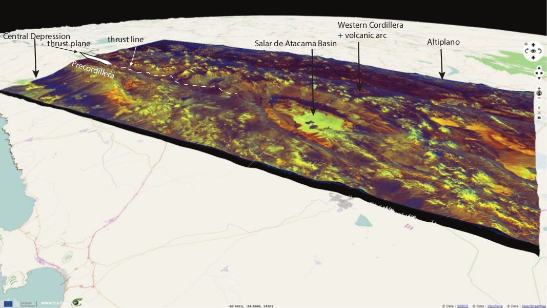
Pr. Jean Chorowicz commented: "During the 12 million year time interval of mostly hyperarid climate there has been little erosion and, in addition, mountains have increased by compression allowing the structural relief to be largely expressed in the landscape. North of the Salar de Atacama basin, an abrupt change in relief and aspect can be clearly observed at the boundary between the Precordillera and the Western Cordillera (Fig.2). This is a major N-striking fault zone along which the Western Cordillera, dragging the Precordillera, is uplifted by more than 1200 m and pushed westward (thrust) over the Precordillera and the Central Depression floor.
The Salar de Atacama Basin is a subsiding area located right at a virgation of this major N-striking fault zone which seems to have a strike-slip right-lateral motion component that may explain such a leaky subsiding area by pull-apart effect."
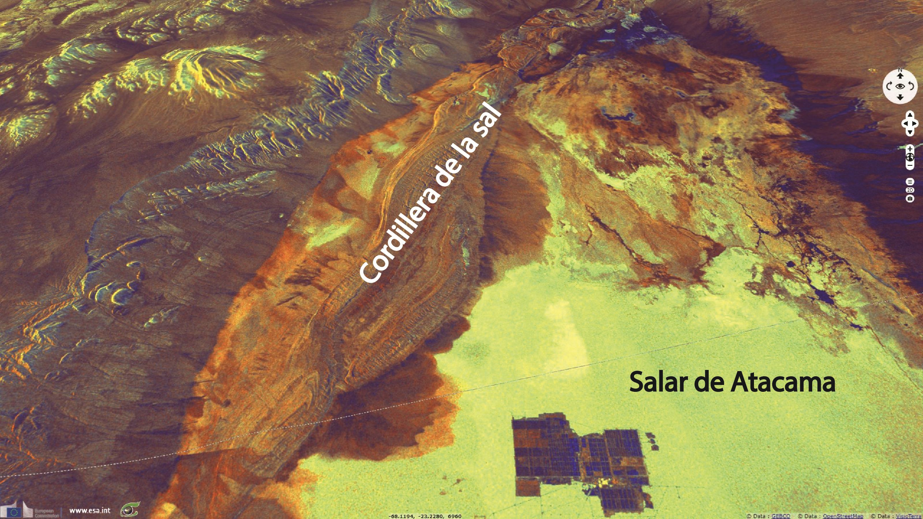
Pr. Jean Chorowicz said about this image: "The flat bottom of the Salar de Atacama Basin, 150 km long and 80 km wide, is at an elevation of ~2300 m. The early Miocene to Quaternary infill is 6 km-thick and composed of salt (halite) and ignimbrites associated to siliciclastic, carbonate or sulfate sediments.
In the northwestern part of the basin (Fig. 3), the small Cordillera de la Sal is a complex recent tectonic fold-and-thrust belt, where Oligocene to Quaternary strata were deformed and uplifted for up to 200 m above the basin floor. The image shows the Cordillera de la Sal Quaternary fold and thrust belt. The bedding planes of the ignimbrites that shape fold closures of the tectonic belt are clearly visible.
The young topography is poorly eroded due to the extremely low erosion and sedimentation rates in the hyper-arid climate. The structure connects in depth with a major reverse fault system known in a nearby seismic profile and testifies for recent activity of the Western Cordillera mountain front."
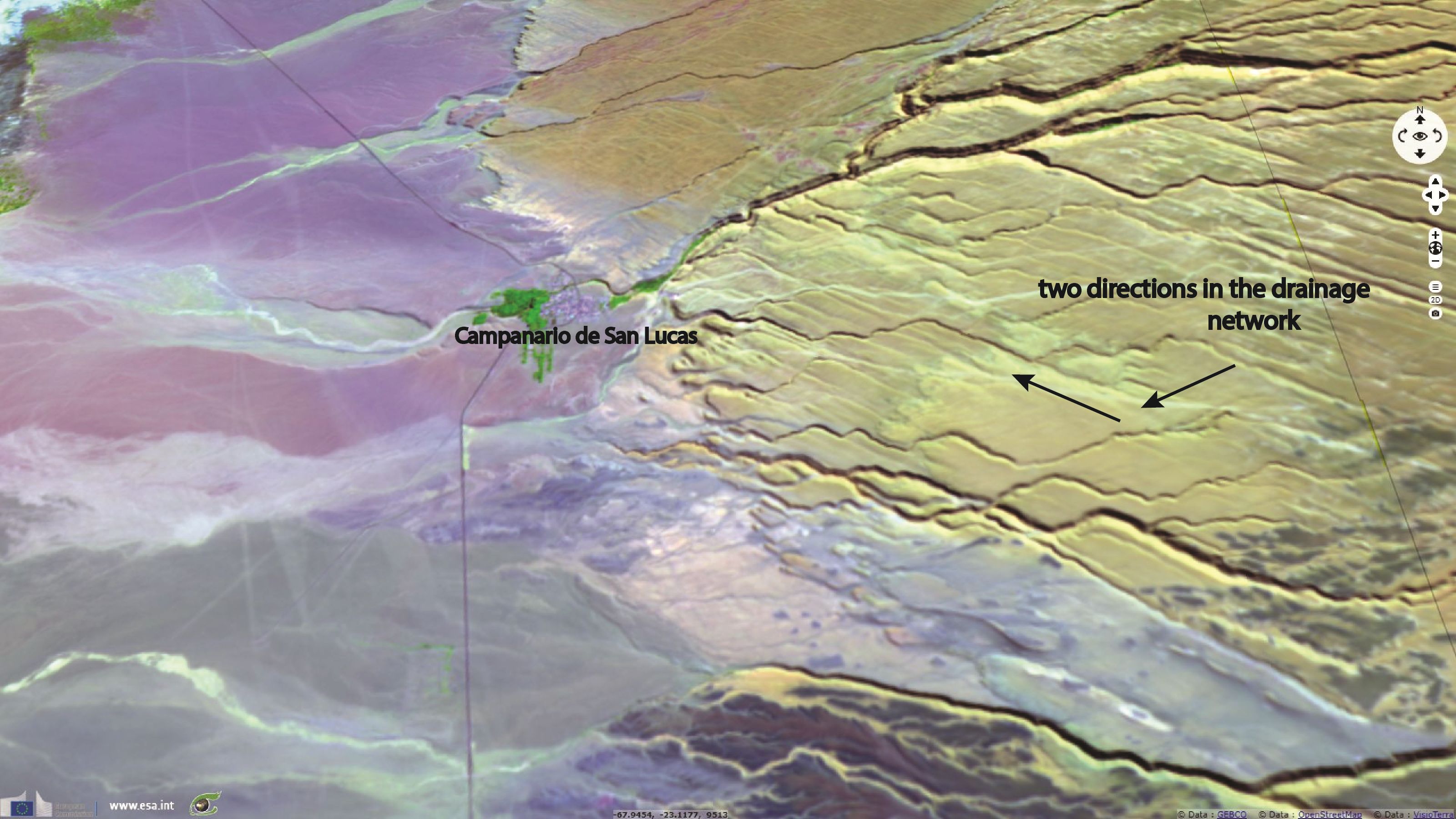
According to Pr. Jean Chorowicz: "Near the village of Campanario de San Lucas, large foothill ancient deposits in the Central Depression are burrowed by a drainage network showing two main directions trending NW or SW. The NW-trending valley segments reactivate faint ondulate surfaces that seem to result from paleo-wind effects. At regional scale these paleo-winds may have blown down from the cold high Western Cordillera to the NW into the depression. The SW trend is more enigmatic. It may follow the regional main slope of the topography."
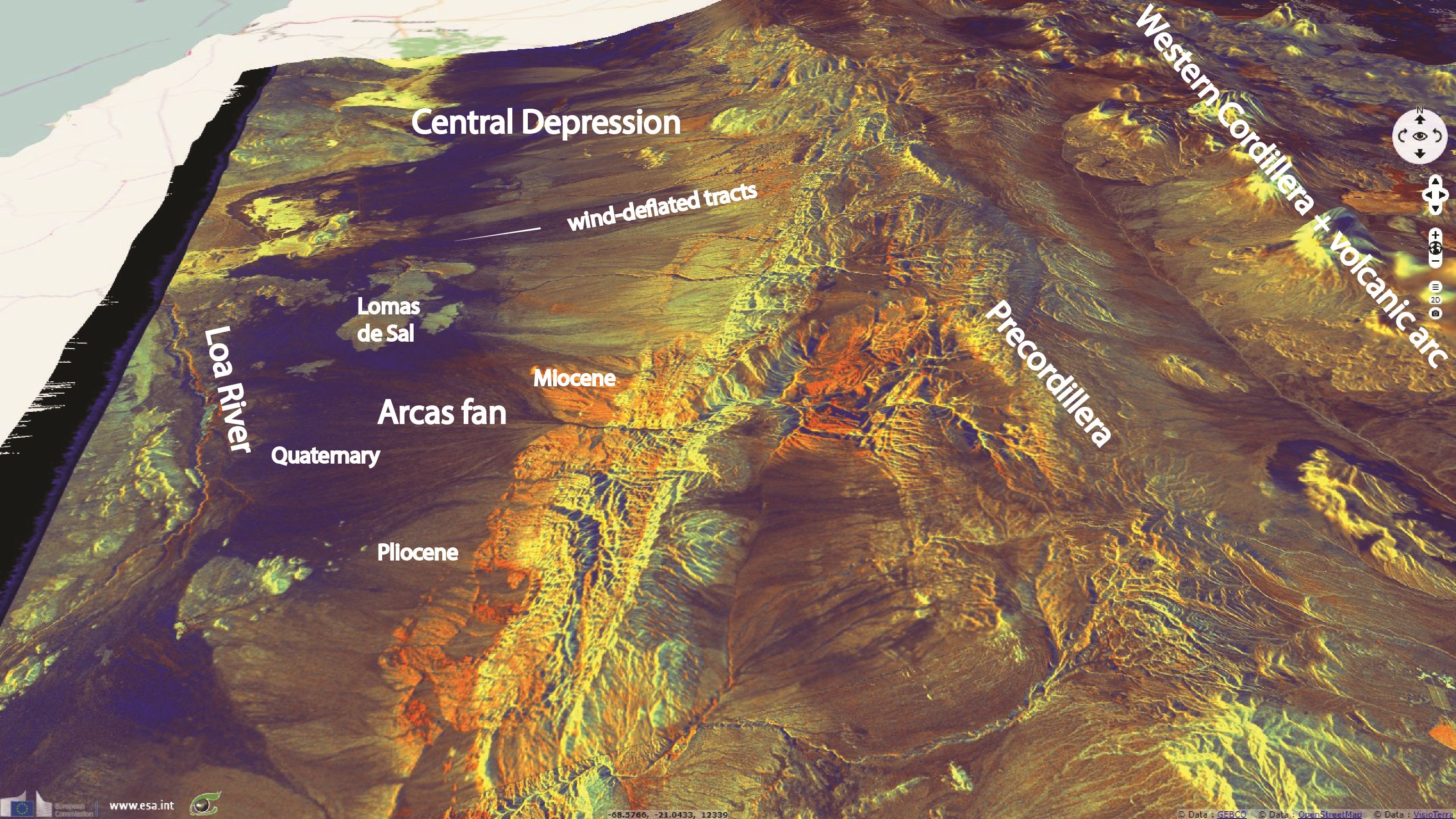
"This image fairly expresses variations in topographic slopes (radar beam from the west) and in ground roughness, light tones for rough surfaces, dark for smooth surfaces. This landscape of the hyperarid core of the Atacama Desert is extraordinarily uncommon, uneroded since millions of years. Presently, the permanent water in the Loa River is almost entirely fed by groundwater discharge." said Pr. Jean Chorowicz. "Alluvial fans are of different ages, the more ancient in the east (light tones and sometimes red-orange, marked Miocene or grey, marked Pliocene) the more recent in the west (black tones, Quaternary). The overall westward shift in fan deposits with time reflects the progressive tectonic uplift of the Precordillera.
Strong winds transport dust and fog aerosols distributing salts from which extensive gypsic soils and deposits form. At Lomas de Sal, thin-grained facies (in black) of alluvial origin are differentiated from rough surface of ancient salt and lacustrine deposits formed in endoreic small basins during the Pliocene. Local cold winds running down from the Precordillera have burrowed broad, straight wind-deflated tracts which smooth surfaces (dark tones) of indurated anhydrite horizons and thin gravel-rich alluvial deposits. The magnificient Quaternary Arcas fan varies in tone from black (smooth mud or sand) to brownish-gray (gravel). Late Miocene deposits that emerge eastward under the fan apex have rough gravel surfaces, expressed in fan shaped red-orange color surfaces. They developed under arid conditions but thereafter in the Miocene short-lived precipitation episodes burrowed gullies, increasing roughness now shown by cross-polarimetric component."
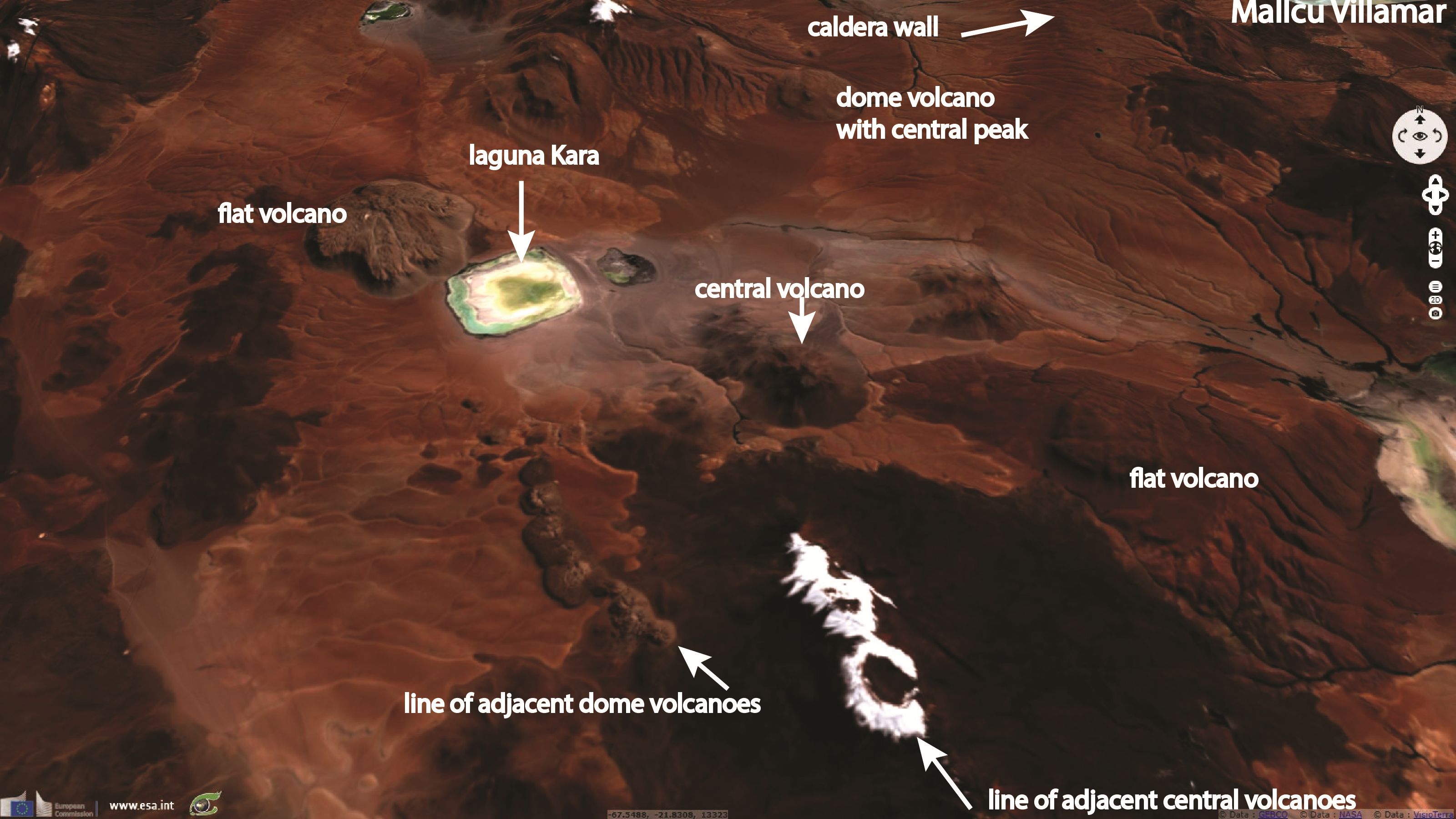
Pr. Jean Chorowicz added: "This volcanic landscape shows rocks colored in brown to black, nevados in white and salt lakes in white to green deposits. The area belongs to the volcanic arc (Western Cordillera), a consequence of the subduction of the Nazca plate.
Central and dome volcanoes are frequent. Both may form aligned adjacent edifices related to the open fractures that have given way up to the magma. Along the line of adjacent dome volcanoes located south of Laguna Kara, each volcano is broken in the middle, showing the open fracture. Other volcanic domes are flat topped, somewhat different from those having a central peak. Such types of flat volcano are also found for instance in Iceland where they are considered to have erupted under glaciers. Volcanoes lying north of Laguna Kara are at the middle of a caldera which eastern wall is partly visible."
The views expressed herein can in no way be taken to reflect the official opinion of the European Space Agency or the European Union.
Contains modified Copernicus Sentinel data 2026, processed by VisioTerra.
Contains modified Copernicus Sentinel data 2026, processed by VisioTerra.
| More on European Commission space: |  |
 |
 |
||||
| More on ESA: | |
|
|
S-1 website | S-2 website | S-3 website | |
| More on Copernicus program: | |
|
|
Scihub portal | Cophub portal | Inthub portal | Colhub portal |
| More on VisioTerra: | |
|
|
Sentinel Vision Portal | Envisat+ERS portal | Swarm+GOCE portal | CryoSat portal |