Relationship between forest fires in Corazon de la Isla Reserve and algal blooms the South Atlantic Ocean
Sentinel-3 OLCI FR acquired on 04 February 2019 at 13:39:32 UTC
Sentinel-2 MSI acquired on 27 November 2021 at 14:00:49 UTC
...
Sentinel-5P TROPOMI AER_AI acquired on 06 December 2022 at 18:48:23 UTC
Sentinel-2 MSI acquired on 28 January 2023 at 14:07:29 UTC
Sentinel-2 MSI acquired on 27 November 2021 at 14:00:49 UTC
...
Sentinel-5P TROPOMI AER_AI acquired on 06 December 2022 at 18:48:23 UTC
Sentinel-2 MSI acquired on 28 January 2023 at 14:07:29 UTC
Keyword(s): Land, coastal, wildfires, protected area, water colour, atmosphere, algal bloom, Argentine, Chile
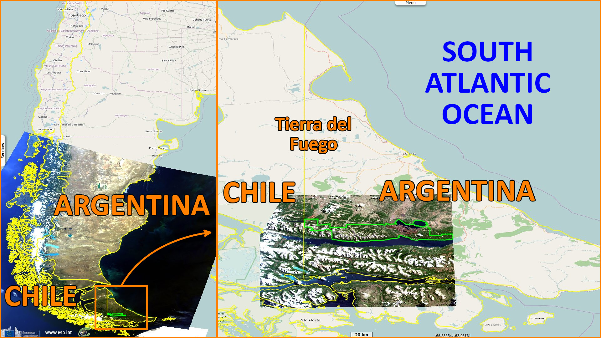
Isla Grande de Tierra del Fuego lies at the southern tip of the South American continent and is shared administratively by Chile and Argentina, writes Mathilde Bigot. It is surrounded by various bodies of water: the Strait of Magellan to the north, the Beagle Channel to the south and the Argentine Sea to the east of the island. Situated at southern latitudes, it has a specifically cold climate, is subject to numerous atmospheric and marine influences and is home to a particular type of vegetation and marine production. Following a fire of unprecedented size on the island, Mathilde Bigot interrogated the impact of this fire on the phytoplankton blooms in the Argentine Sea. This study was carried out in the CADIC-CONICET research centre of Ushuaia, under the direction of Facundo Barrera and Irene Schloss.
"These geological formations are at the origin of the soils that currently occupy the Tierra del Fuego. The main ones are, in order of occurrence (de Valle, 1998; USDA, 2023):
- Inceptisols: wet soils, characteristic of harsh environmental conditions, which slow down soil development,
- Mollisols: rich in organic matter and dark in colour, typical of steppe and plateau areas,
- Podzosols: formation soils with low clay content, with potential iron and aluminium accumulation horizons. They develop in mountainous regions and near lakes,
- Andisols: soils formed on volcanic sediments, they are dark but have good water retention capacity. However, they limit surface rooting,
- Histosols: soils with a high concentration of organic matter,
- Alfisols: soils with a high water retention capacity.

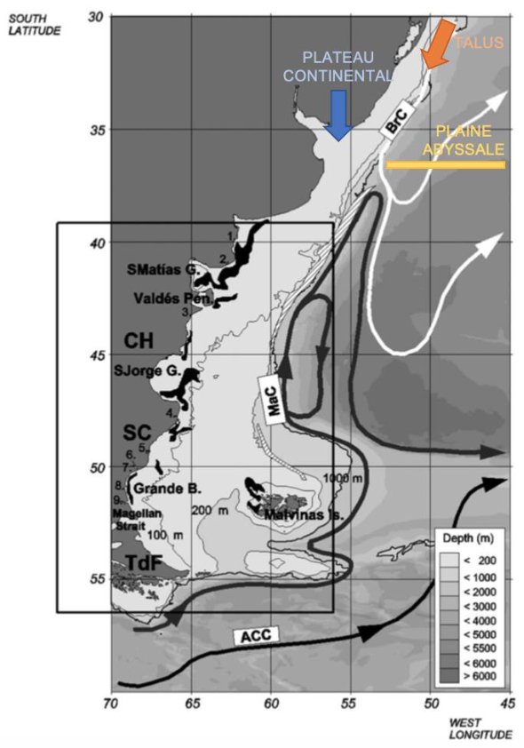 The white boxes represent the currents: MaC: Falklands Current; ACC: Circumpolar Current; BrC: Brazil Current.
The arrows represent the movement of the above currents.
The black letters indicate cities: CH: Chubut; SC: Santa Cruz; TdF: Tierra del Fuego.
The numbers indicate river mouths: 1: Colorado; 2: Negro; 3: Chubut; 4: Deseado; 5: San Julian; 6: Chico; 7: Santa Cruz; 8: Coig; 9: Gallegos.
The Argentine Sea is characterised by a large continental shelf, 1000 km long and up to 800 km off the coast, the continental slope, which reaches depths of 200m, and the abyssal plain, where the seabed can reach depths of up to 4000m (Coupel, 2015). These bathymetric features and the extent of these formations to low latitudes give rise to numerous ocean currents.
The white boxes represent the currents: MaC: Falklands Current; ACC: Circumpolar Current; BrC: Brazil Current.
The arrows represent the movement of the above currents.
The black letters indicate cities: CH: Chubut; SC: Santa Cruz; TdF: Tierra del Fuego.
The numbers indicate river mouths: 1: Colorado; 2: Negro; 3: Chubut; 4: Deseado; 5: San Julian; 6: Chico; 7: Santa Cruz; 8: Coig; 9: Gallegos.
The Argentine Sea is characterised by a large continental shelf, 1000 km long and up to 800 km off the coast, the continental slope, which reaches depths of 200m, and the abyssal plain, where the seabed can reach depths of up to 4000m (Coupel, 2015). These bathymetric features and the extent of these formations to low latitudes give rise to numerous ocean currents.
- To the north of Argentina, the Brazil Current (BrC) is carried from the north of South America up to 38°S. With plenty of light available, this current brings warm waters towards southern Argentina,
- The Falklands Current (MaC) progresses from the Drake Passage towards the north of Argentina, following the continental slope. It brings cold waters that are rich in nutrients, particularly oxygen,
- A confluence zone between the MaC and the BrC exists at 40°S, mixing cool and warm waters, temperatures and salinity respectively, creating a Shelf Break Front,
- The circumpolar current moves from west to east and separates the Antarctic continent. The waters here are cold and rich in oxygen,
- The Argentine continental shelf, with its multiple influences, is an area of high primary production.
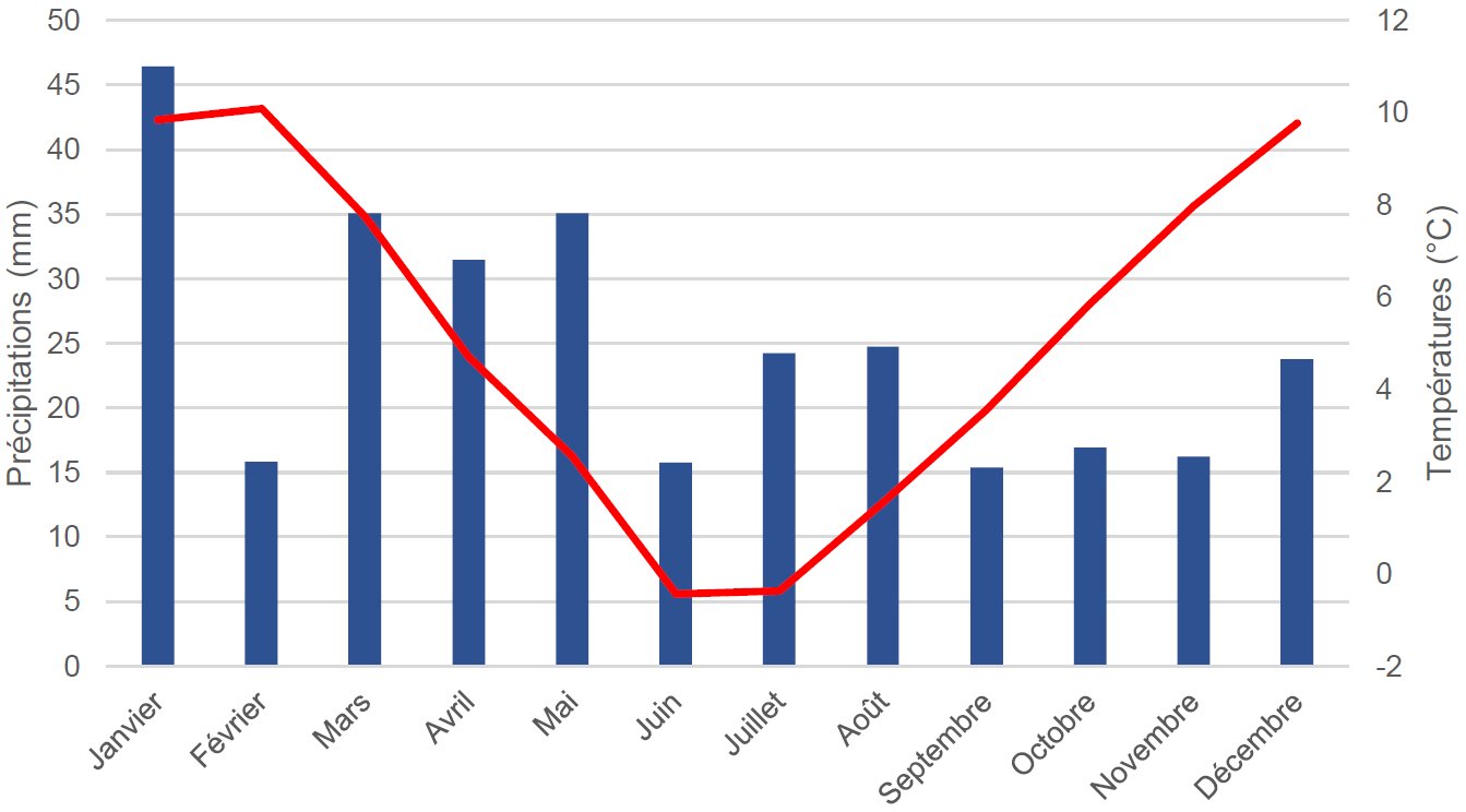 Tierra del Fuego is home to cold climates, divided between the "magallanico" climate to the north and the humid "los Andes patagonicos-fueguinos" climate to the south. These climates are characterised by heavy annual rainfall, but also by snowfall, and by the influence of the South Pacific and Antarctic fronts.
In terms of temperature, annual averages vary between 6°C and 8°C on the island, with little daily variation.
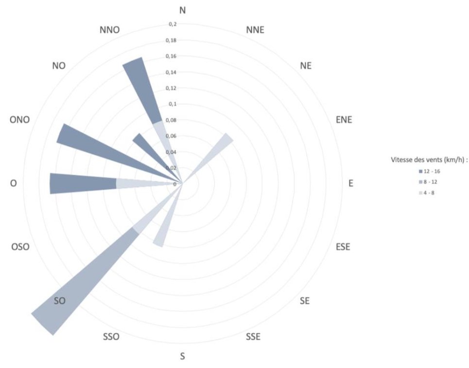
Isla Grande de Tierra del Fuego lies between two subtropical and Antarctic precipitation nuclei (Allué, 2010). Atmospheric pressure in Tierra del Fuego is influenced by the Andes, which in turn is impacted by Pacific atmospheric circulations. The vast majority of winds come from the west, and are very intense, mainly in summer and autumn. Influences from the Atlantic can bring less frequent easterly winds.
Annual rainfall is around 300 to 800 mm, with maximum rainfall between May and October. It is mainly due to the influence of the sea in summer and autumn that rainfall is highest, although it is significant throughout the year.
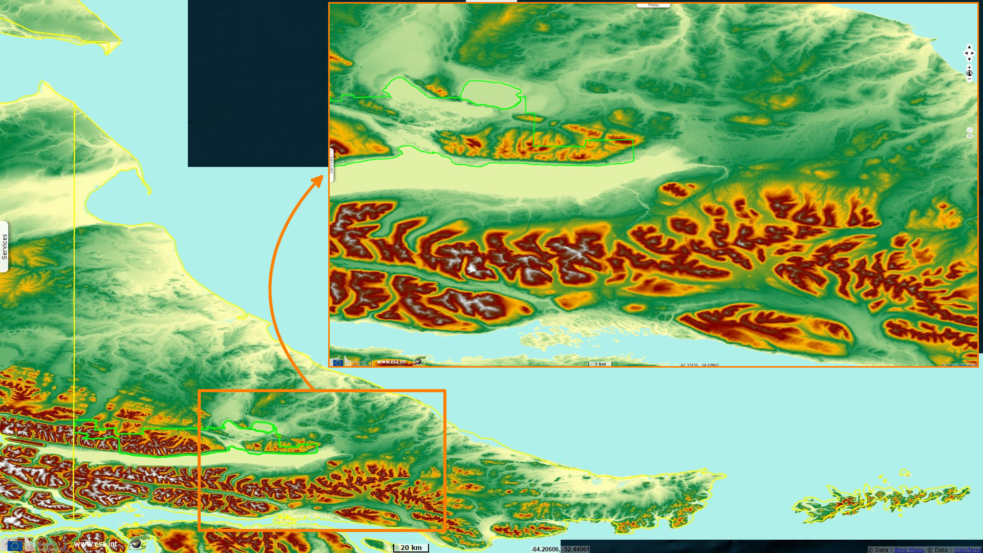
The Corazón de la Isla Reserve is home to a mixed grove of Nothofagus pumilio (Lenga) and Nothofagus antarctica (Ñire) trees, as well as grasslands, peat bogs and, to the south of the Reserve, Nothofagus betuloides (Guindo). With a surface area of 100,000 hectares, it was categorised as a Natural Recreational Reserve under provincial law no. 494, with the aim of revitalising the centre of the island, developing tourism and conserving its biodiversity.
Tierra del Fuego is home to cold climates, divided between the "magallanico" climate to the north and the humid "los Andes patagonicos-fueguinos" climate to the south. These climates are characterised by heavy annual rainfall, but also by snowfall, and by the influence of the South Pacific and Antarctic fronts.
In terms of temperature, annual averages vary between 6°C and 8°C on the island, with little daily variation.
Isla Grande de Tierra del Fuego lies between two subtropical and Antarctic precipitation nuclei (Allué, 2010). Atmospheric pressure in Tierra del Fuego is influenced by the Andes, which in turn is impacted by Pacific atmospheric circulations. The vast majority of winds come from the west, and are very intense, mainly in summer and autumn. Influences from the Atlantic can bring less frequent easterly winds.
Annual rainfall is around 300 to 800 mm, with maximum rainfall between May and October. It is mainly due to the influence of the sea in summer and autumn that rainfall is highest, although it is significant throughout the year.
The Corazón de la Isla Reserve is home to a mixed grove of Nothofagus pumilio (Lenga) and Nothofagus antarctica (Ñire) trees, as well as grasslands, peat bogs and, to the south of the Reserve, Nothofagus betuloides (Guindo). With a surface area of 100,000 hectares, it was categorised as a Natural Recreational Reserve under provincial law no. 494, with the aim of revitalising the centre of the island, developing tourism and conserving its biodiversity.
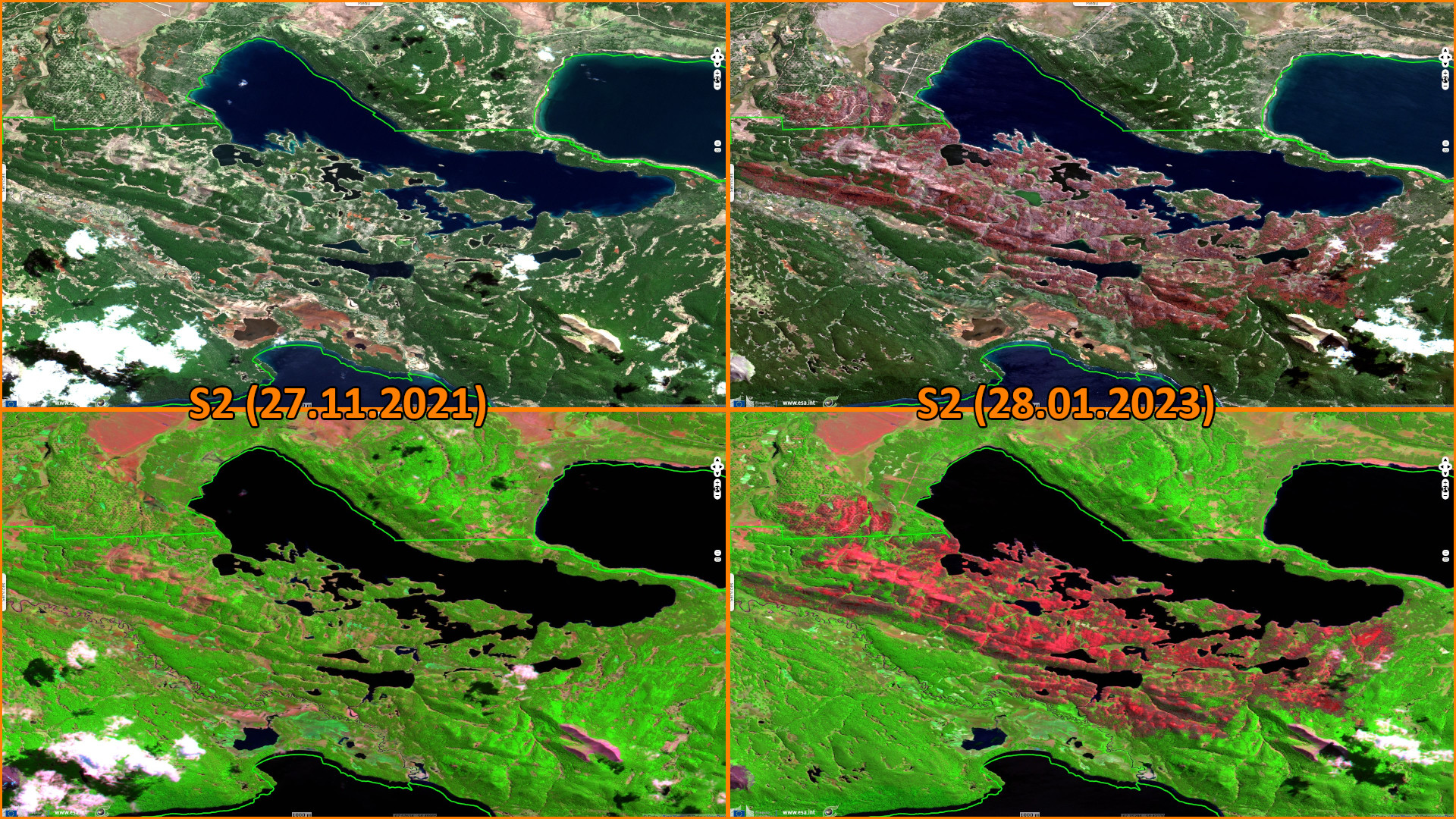
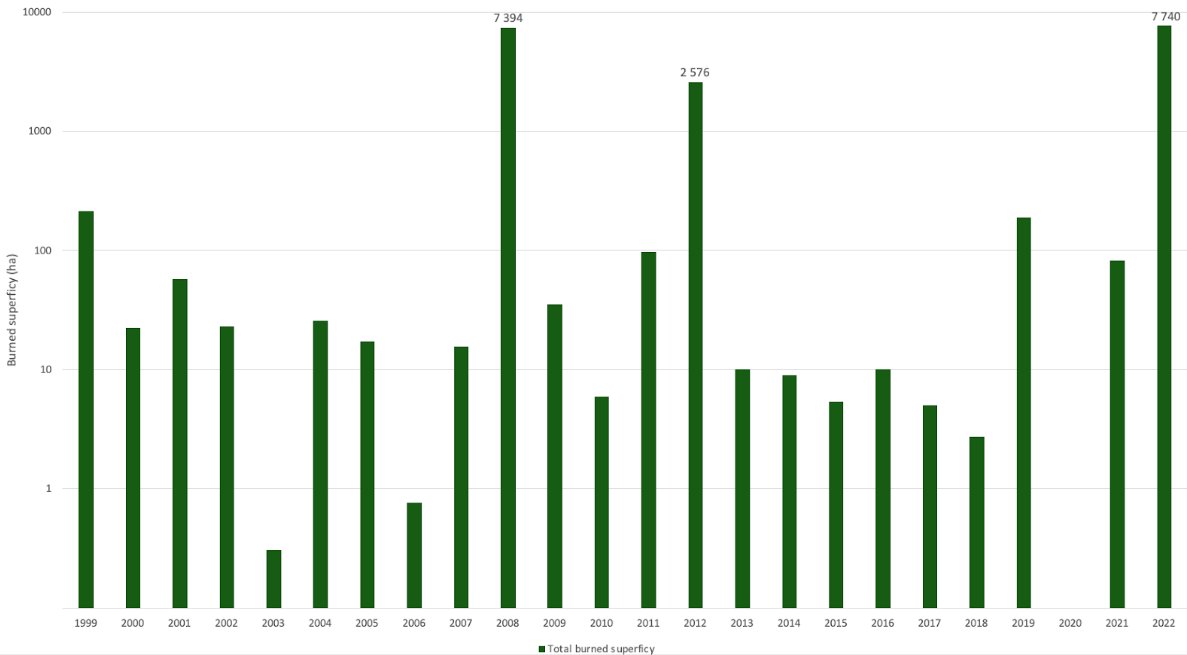
The recent fires in the Corazón de la Isla reserve started on 30 November 2022 and affected up to 9000 ha of vegetation and represent one of the most catastrophic events in Tierra del Fuego in the last hundred years, notes Mathide Bigot. Tierra del Fuego is not an area where the dynamics of forest fires are common or natural, but it is not immune to them. A census of fires in the province shows the evolution of fires between 1999 and 2021 according to Dirreción Nacional de Bosques, 2023.
Temperatures in November were high compared with the monthly average (8°C). Rainfall was also low, particularly thirty days before the start of the fires, well below annual averages.
These combined conditions can lead to drought and encourage fires to start. Precipitation during the fires and afterwards was heavy, and this could cause material to be transported by run-off, leading to ash being deposited at sea in Argentina, but also allowing aerosols in the air to be deposited.
The wind regime shows atmospheric movements from west to east, which can also transport particles in the air, aerosols, as far as the Argentine Sea.
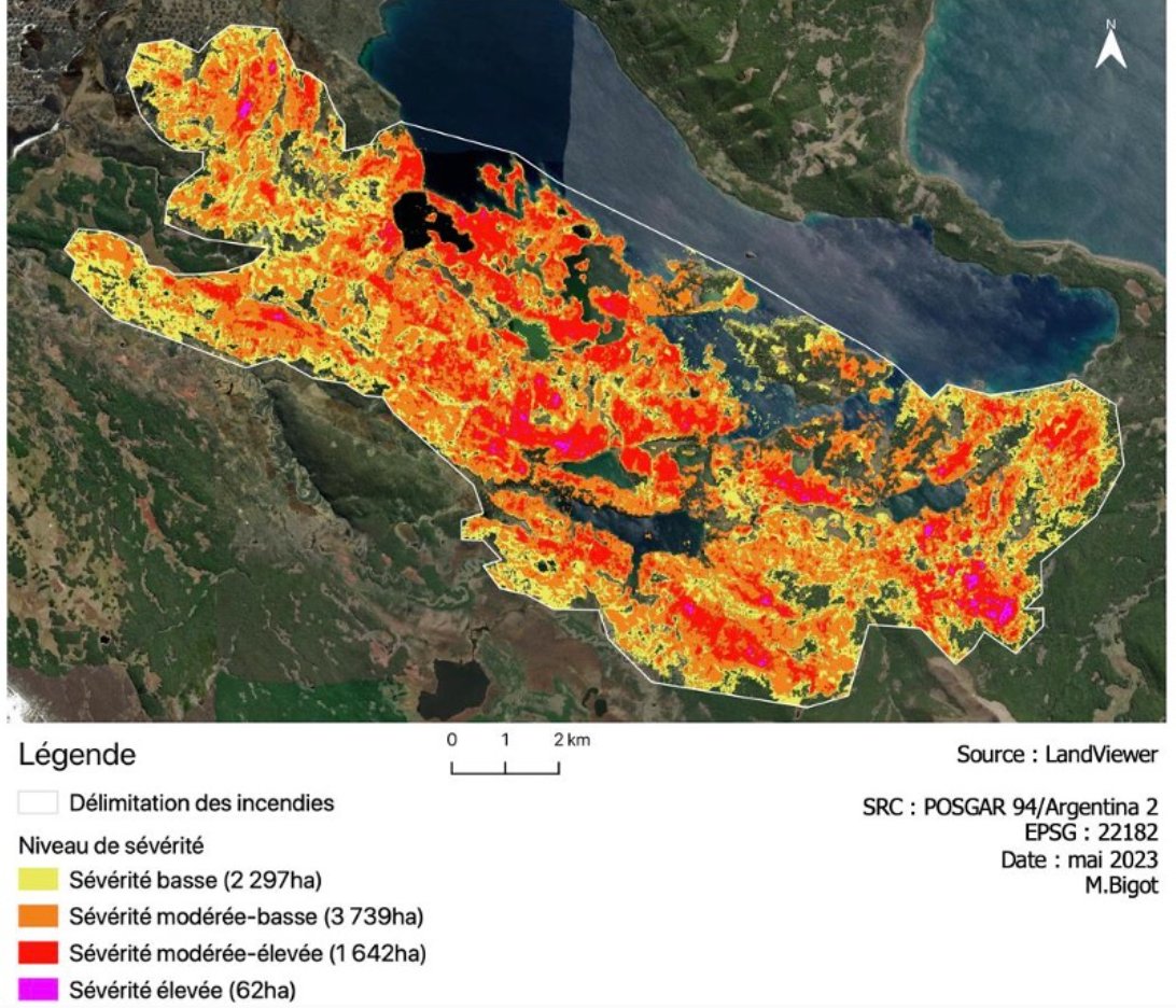 Developed by Hunt and Rock in 1989, the NBR index is used to define and assign a degree of severity to burnt areas following a fire. It measures reflectance in the near infrared (NIR) and short-wave infrared (SWIR) bands. Compared with a pre-fire situation, the dNBR is calculated as follows: dNBR = NBRpre - NBRpost
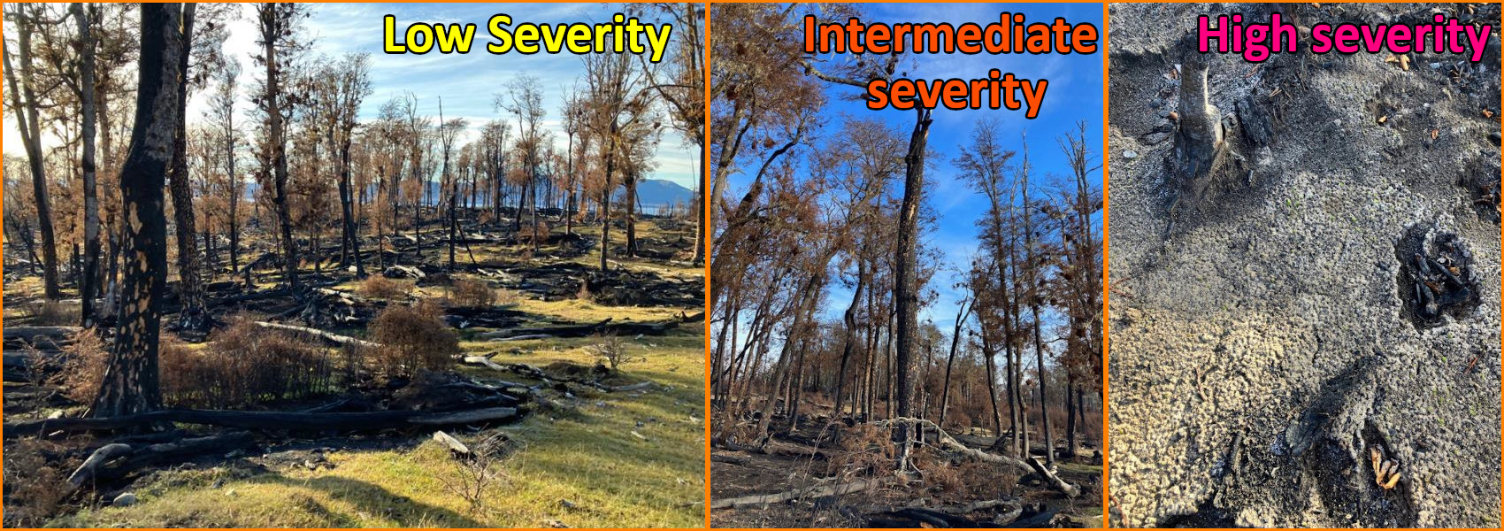
Photograph of the fire at Estancia Los Cerros - Source: Mathilde Bigot, 08/05/2023:
- Left: low severity zone, covered ground and partially burnt vegetation
- Centre: moderate severity zone, large portion of ground and vegetation burnt, presence of dark ashes
- Right: high severity zone, presence of grey ash, vegetation almost completely burnt.
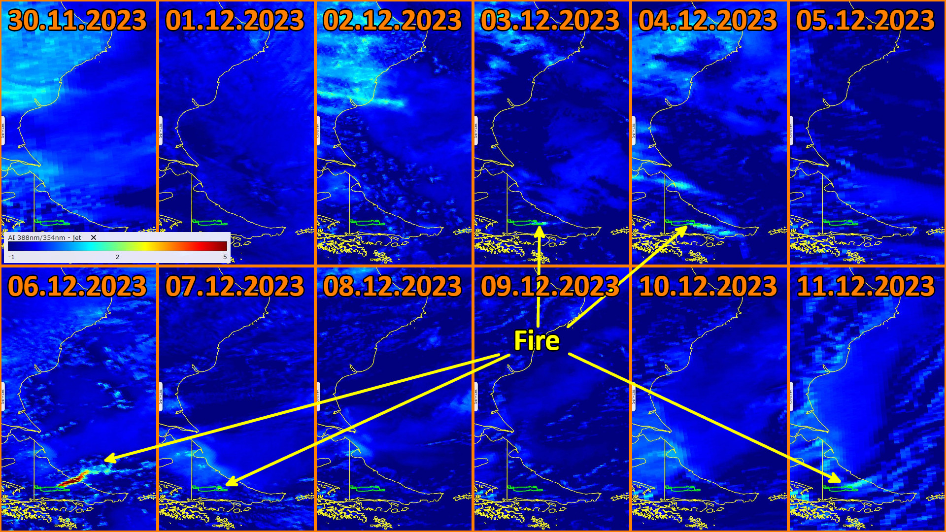
The plume generated by the fires produced airborne matter known as aerosols. Aerosols are measured by a UV aerosol index, in this case by the TROPOMI instrument on the Sentinel-5P. By processing the product, we identify the beginning of fires (30.11.2022-11.12.2022) as the peak of aerosol emissions.
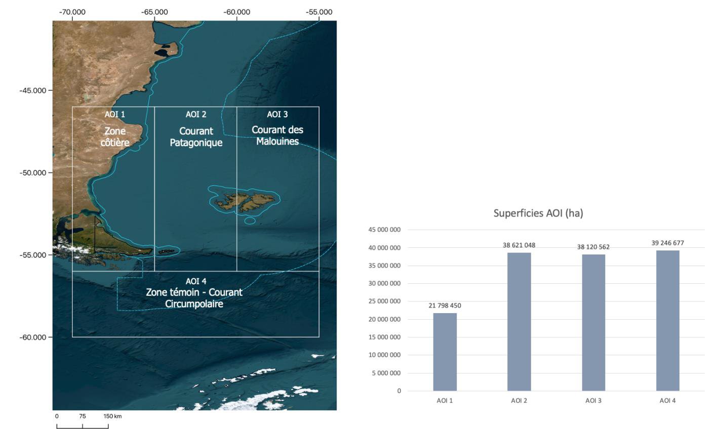
Identification of the areas of interest in the analysis of the oceanic part of the study. a) Mapping of the areas of interest; b) Graph of the maritime surface areas of the areas of interest.
In this study, Mathilde Bigot defined four Areas of Interest (AOI):
- AOI 1: Coastal Zone, representing a maritime area of 21,798,450 ha,
- AOI 2: Patagonian Current, covering a maritime area of 38,621,048 ha,
- AOI 3: Falklands Current, representing a maritime area of 38,120,562 ha,
- AOI 4: Circumpolar Current, as a control zone where variations are rare, represents a maritime surface area of 39,246,677 ha.
 There have rarely been such virulent fires in Tierra del Fuego as those in the Corazón de la Isla Reserve last November. As a comparison with the Australian work, the same method was applied, but the context was different, particularly in terms of the total area burnt. The similarities lay in the effect of the burning of the vegetation at the origin of aerosol dispersion in the air, and the response of the Chla some time after the maximum aerosol emissions.
Mathilde Bigot concludes: It is in the area closest to the shore that the correlation was the higher. But there are limits to the composition of these aerosols and their actual deposition on land or at sea. The combustion of vegetation accounts for a large proportion of the ash, and this aspect is not mentioned here.
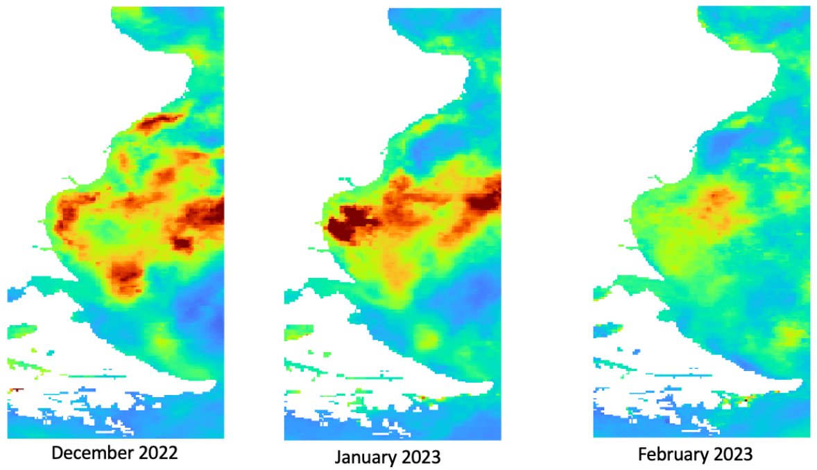
The fires in the RCI lasted up to five and a half months, with the maximum aerosol production occurring in just one week and relatively little rainfall. Given the strong power of ocean currents in the maritime zone studied, it is possible that these aerosols were not assimilated by the ocean. Lastly, Chla concentrations are always variable, and the correlation should be further investigated before any final conclusions can be drawn as to cause and effect.
It is possible that the impact of melting ice in Antarctica is also affecting thermocline dynamics, and more specifically the concentration of chlorophyll in the ocean and the survival of certain phytoplankton species (Schloss, 2015).
There have rarely been such virulent fires in Tierra del Fuego as those in the Corazón de la Isla Reserve last November. As a comparison with the Australian work, the same method was applied, but the context was different, particularly in terms of the total area burnt. The similarities lay in the effect of the burning of the vegetation at the origin of aerosol dispersion in the air, and the response of the Chla some time after the maximum aerosol emissions.
Mathilde Bigot concludes: It is in the area closest to the shore that the correlation was the higher. But there are limits to the composition of these aerosols and their actual deposition on land or at sea. The combustion of vegetation accounts for a large proportion of the ash, and this aspect is not mentioned here.
The fires in the RCI lasted up to five and a half months, with the maximum aerosol production occurring in just one week and relatively little rainfall. Given the strong power of ocean currents in the maritime zone studied, it is possible that these aerosols were not assimilated by the ocean. Lastly, Chla concentrations are always variable, and the correlation should be further investigated before any final conclusions can be drawn as to cause and effect.
It is possible that the impact of melting ice in Antarctica is also affecting thermocline dynamics, and more specifically the concentration of chlorophyll in the ocean and the survival of certain phytoplankton species (Schloss, 2015).
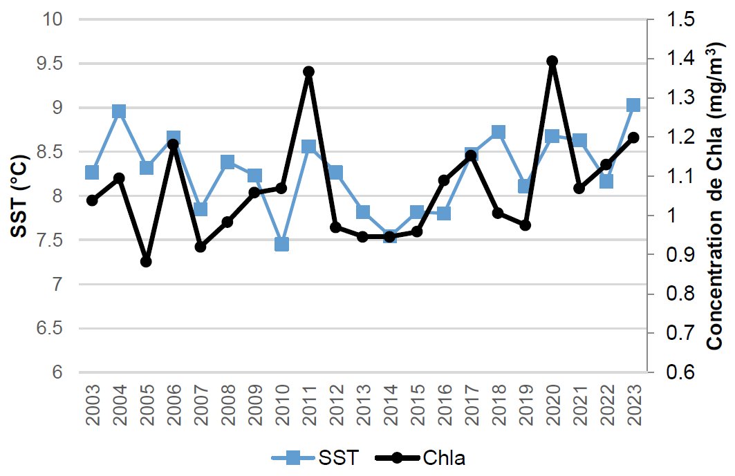 Water surface temperature is also a major factor in the mixing of water masses when currents meet. Chla and primary production are also affected. A rise in sea temperature has an impact on the Chla by increasing its concentration. This correlation would have to be further studied to quantify the impact of sea fertilisation by wildfires.
The views expressed herein can in no way be taken to reflect the official opinion of the European Space Agency or the European Union.
Contains modified Copernicus Sentinel data 2026, processed by VisioTerra.
Contains modified Copernicus Sentinel data 2026, processed by VisioTerra.
| More on European Commission space: |  |
 |
 |
||||
| More on ESA: | |
|
|
S-1 website | S-2 website | S-3 website | |
| More on Copernicus program: | |
|
|
Scihub portal | Cophub portal | Inthub portal | Colhub portal |
| More on VisioTerra: | |
|
|
Sentinel Vision Portal | Envisat+ERS portal | Swarm+GOCE portal | CryoSat portal |