Aftermath of hurricane Harvey in Texas
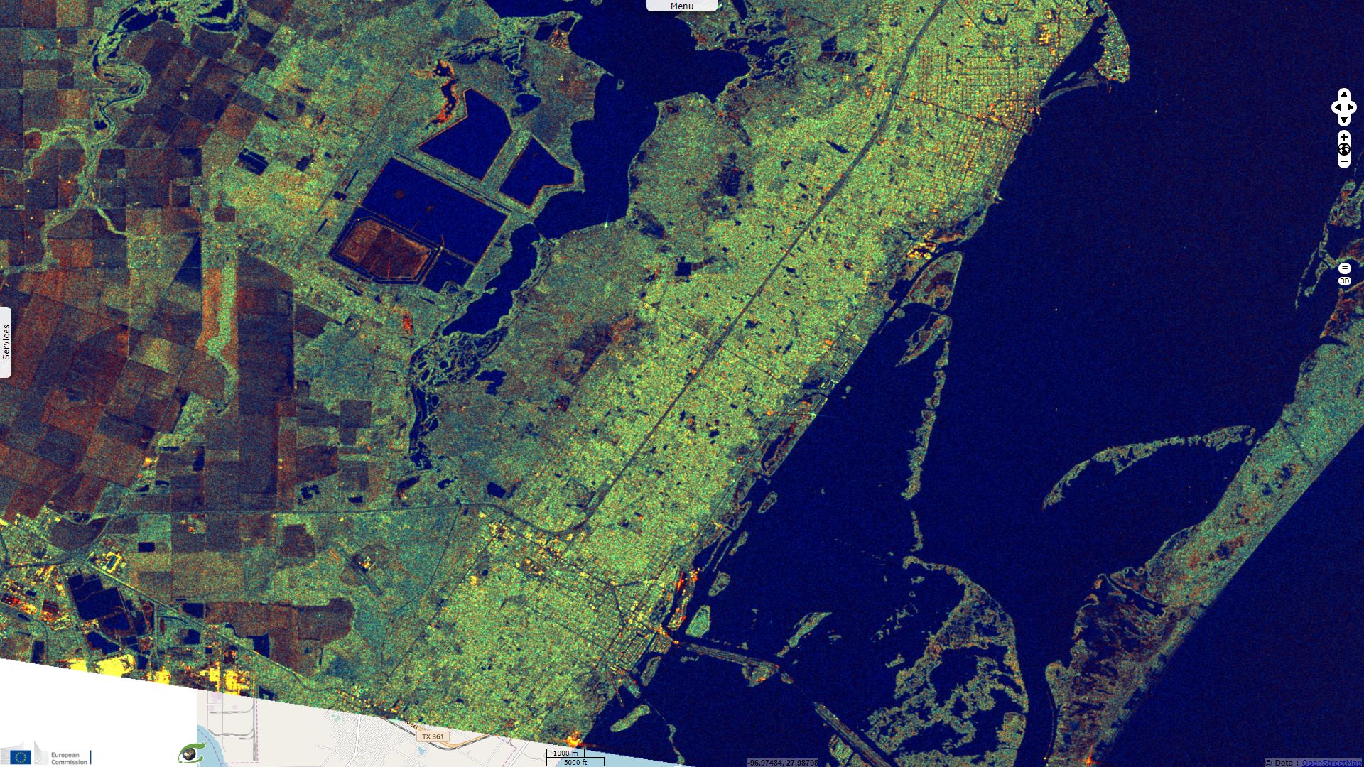
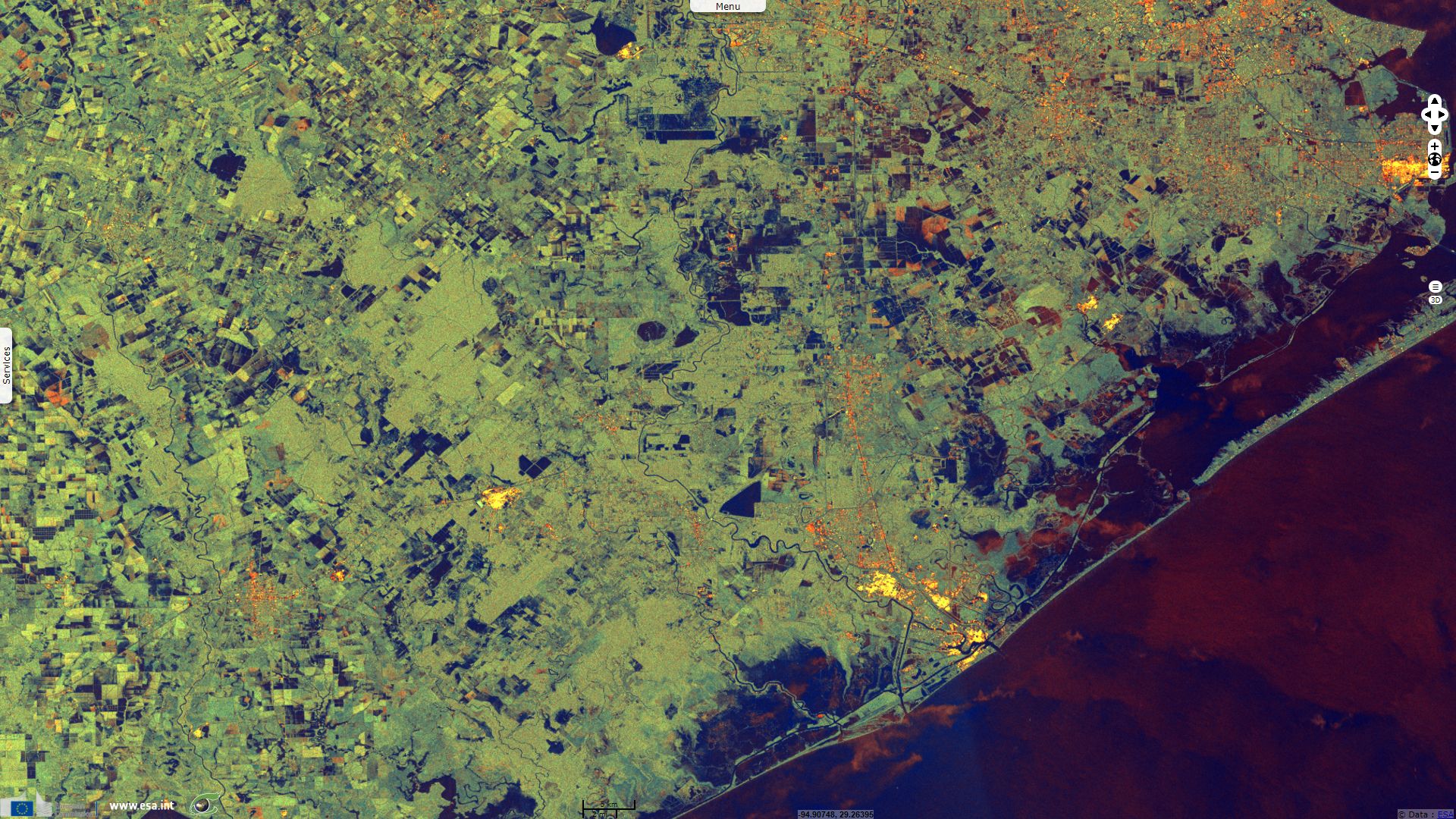
Sentinel-1 CSAR IW acquired on 05 August 2017 at 00:26:19 UTC
...
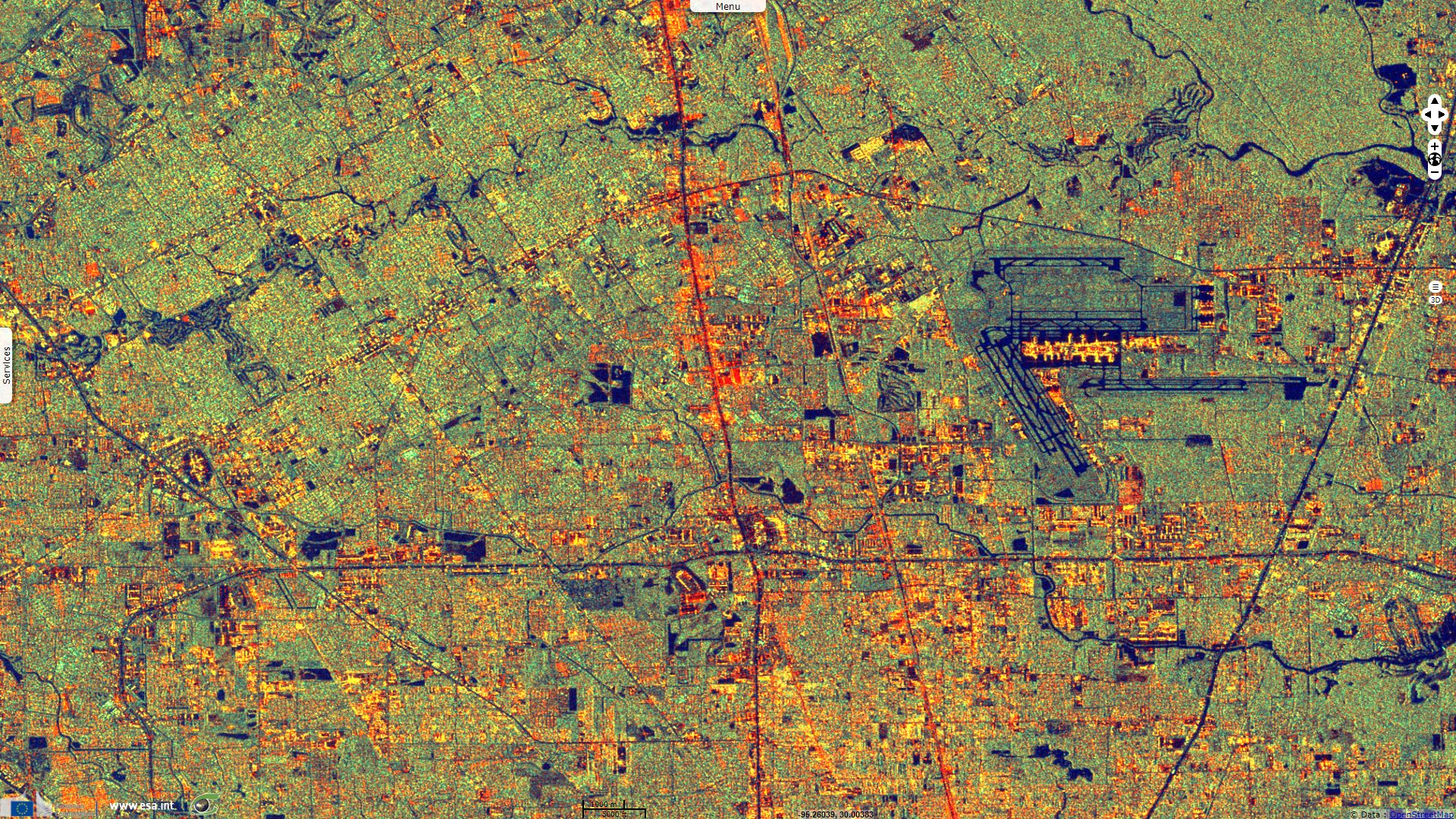
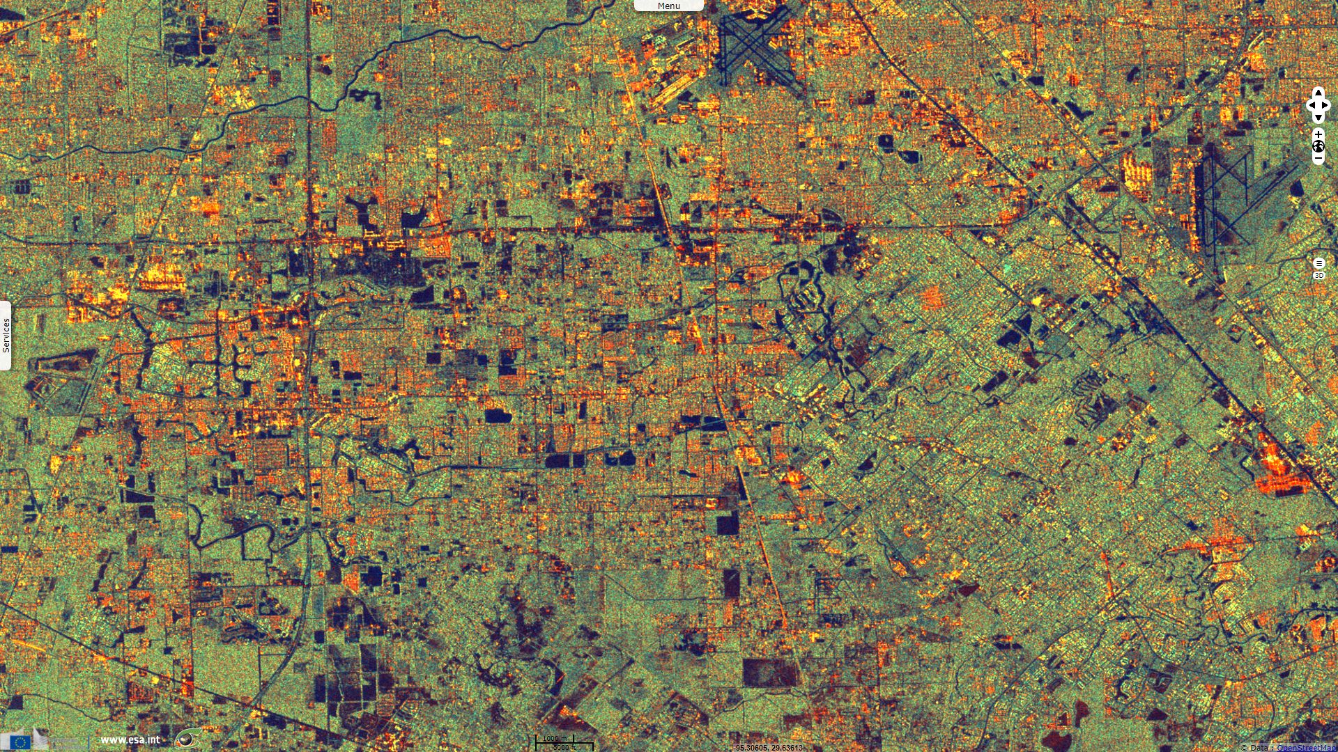
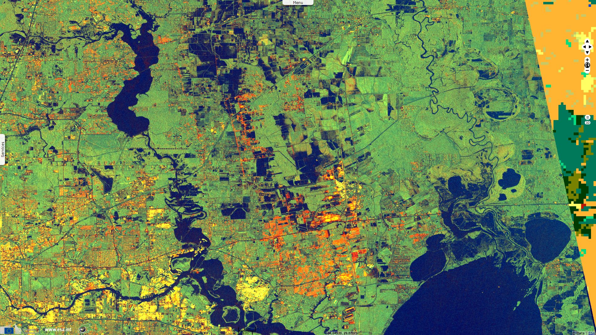
Sentinel-1 CSAR IW acquired on 29 August 2017 from 00:26:20 to 00:26:45 UTC
Sentinel-1 CSAR SM acquired on 30 August 2017 from 00:17:40 to 12:22:32 UTC
...
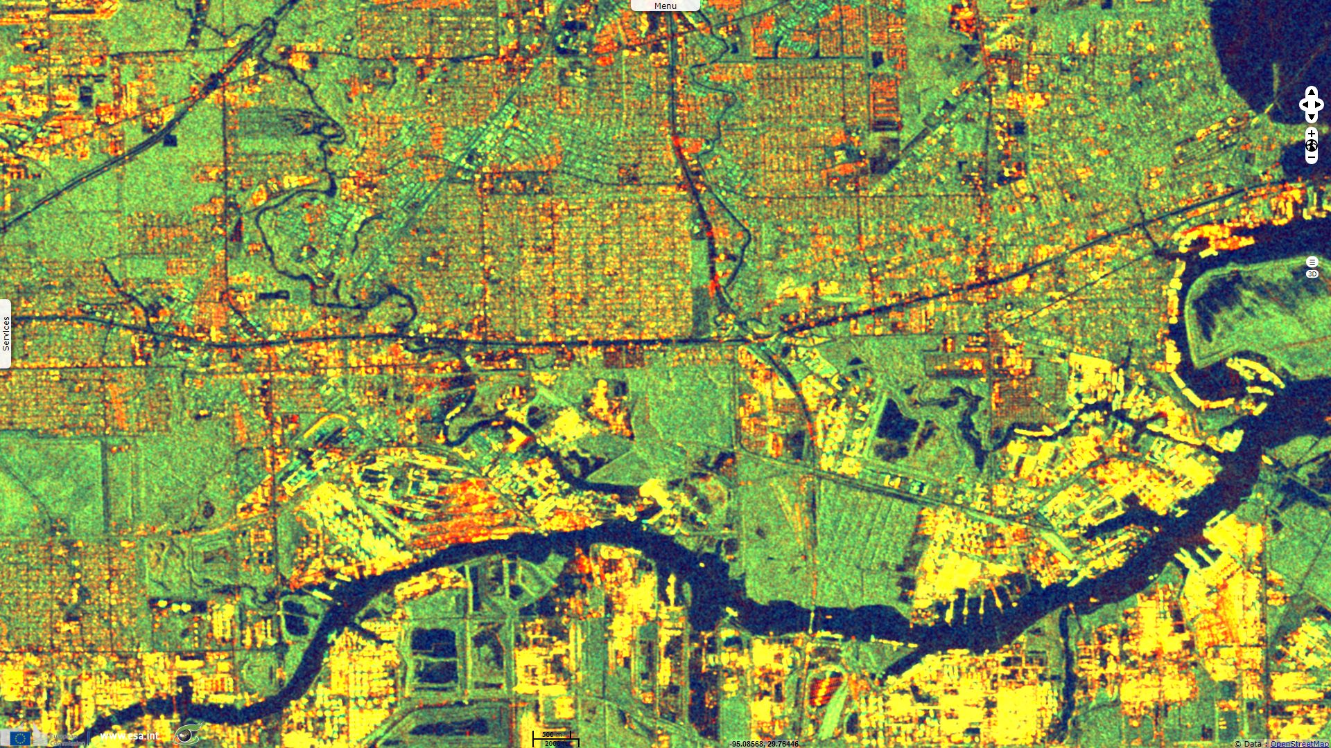
Sentinel-1 CSAR IW acquired on 29 August 2017 from 00:26:20 to 00:26:45 UTC
Sentinel-1 CSAR SM acquired on 30 August 2017 from 00:17:40 to 12:22:32 UTC
Keyword(s): Natural disaster monitoring, climate change, hurricane, cyclone, atmosphere, rain, flooding, flood plain, urban planning, subsidence, Houston, Texas, USA, United States
Hurricane Harvey is the hardest hitting hurricane in Texas in recorded history. The Guardian commented the landfall of hurricane Harvey: "Harvey made landfall near Corpus Christi late on Friday as a category 4 hurricane with maximum winds of [210kph]. It was the first category 4 storm in the US since 2004 when Charley menaced Florida; Texas had not endured such a powerful hurricane since Carla in 1961.".
Dave Hennen, CNN senior meteorologist, added: "What is unique in Harvey is that as the storm moved inland, a large high pressure built in to the north and, basically, the steering currents, which guide Harvey, collapsed. [...] This has caused the extremely slow movement of the storm, moving only around 60 miles, less than 2 miles per hour. This has allowed the bands of storms to move over the same areas over and over."
CNN reported: "The storm dumped an estimated [102km3] of rain over Texas and Louisiana over six days, said Ryan Maue, of the weather analytics company WeatherBell." USA Today wrote: "this broke the contiguous-U.S. rainfall record for a tropical storm or hurricane, preliminary data from the National Weather Service show.".
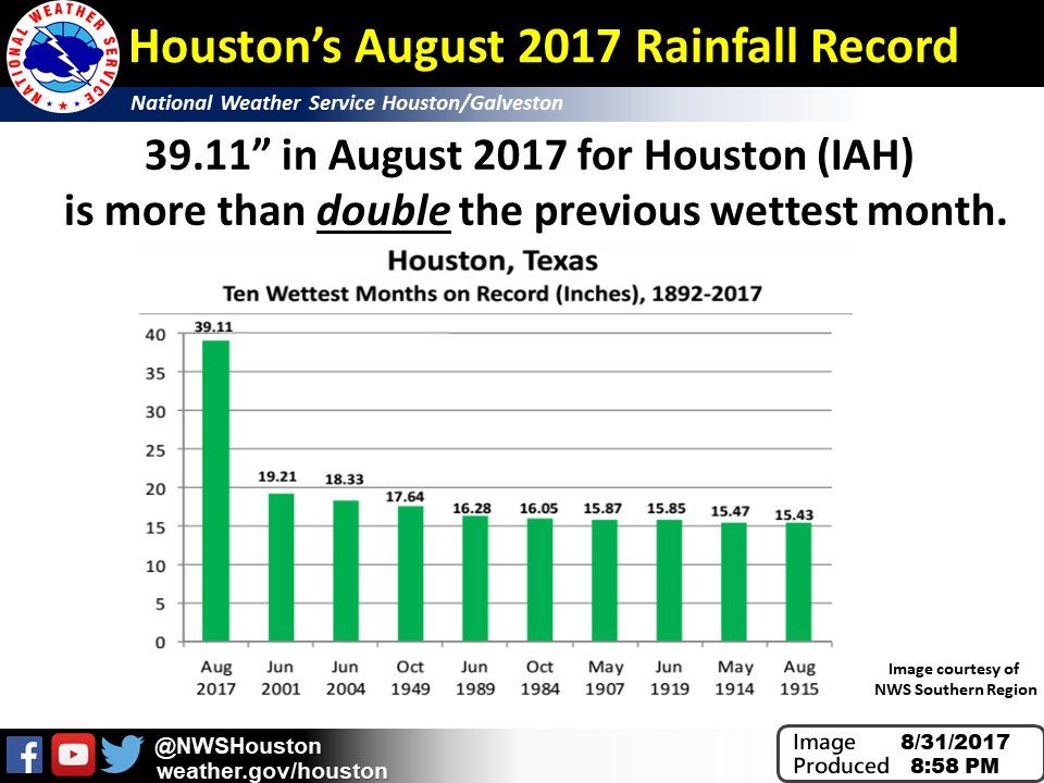
According to National Weather Service Houston: "Houston's August 2017 rainfall total [99 cm] is more than double the previous wettest month".
Texas suffered heavily from hurricane Harvey. Asked by the The Chicago Tribune, Jeff Lindner, a meteorologist with the county flood control district estimates: "Between 25 and 30 percent of Harris County [1150km²] - home to 4.5 million people in Houston and its near suburbs - was flooded by Tuesday afternoon [31.07].".
CNN announced: "at least 50 people have died from the storm", CNN reports: "More than 72,000 people have been rescued." and Reuters wrote that at the peak, : "around 300,000 [...] were without power".
While Harvey soon receded from category-4 hurricane to a storm status, inhabitants are not safe yet. The Guardian warned: "The Environmental Protection Agency (EPA) has said water contamination is the greatest threat to human health now that Harvey has weakened and passed through to the north. On Sunday, the EPA said that 166 drinking water systems affected by Harvey have boil water notices, with a further 50 shut down. Residential wells are currently being tested for pollution.".
The New-York Times added "flooded sewers are stoking fears of cholera, typhoid and other infectious diseases. Runoff from the city’s sprawling petroleum and chemicals complex contains any number of hazardous compounds. Harris County, home to Houston, hosts more than two dozen current and former toxic waste sites designated under the federal Superfund program. The sites contain what the Environmental Protection Agency calls legacy contamination: lead, arsenic, polychlorinated biphenyls, benzene and other toxic and carcinogenic compounds from industrial activities many years ago [...] may be leaching."
Americans expect the material toll to rise to that of the most destructive disasters it faced.
The Los Angeles Times enumerates: "Beetween the shutdown of oil refineries and chemical plants, impaired roads and ports, and widespread damage to homes, businesses and cars, the economic toll from Hurricane Harvey is now being estimated as the second-costliest natural disaster in U.S. history, trailing only the devastation caused by Hurricane Katrina in 2005. Some economic researchers, including the national forecasting firm Moody’s Analytics, are putting the price tag of Harvey at $81 billion to $108 billion or more, most of that in damage to homes and commercial property. Moody’s estimated that as many as 700,000 vehicles and 400,000 homes were significantly damaged. Most homeowners did not have flood insurance, so their personal spending will be constrained.
That would be larger than the hit from Hurricane Sandy in 2012 but less than Katrina, which inflicted $175 billion in damage and lost economic activity. By comparison, the economic loss from the Northridge earthquake in 1994 came to about $45 billion, in inflation-adjusted dollars, according to Moody’s."
A problem likely to worsen the fate of victims is that only inhabitants living in the areas designated by FEMA as within the 100-year flood areas are required to take a flood insurance. Few outside these areas do, so only a minority of the people are insured.
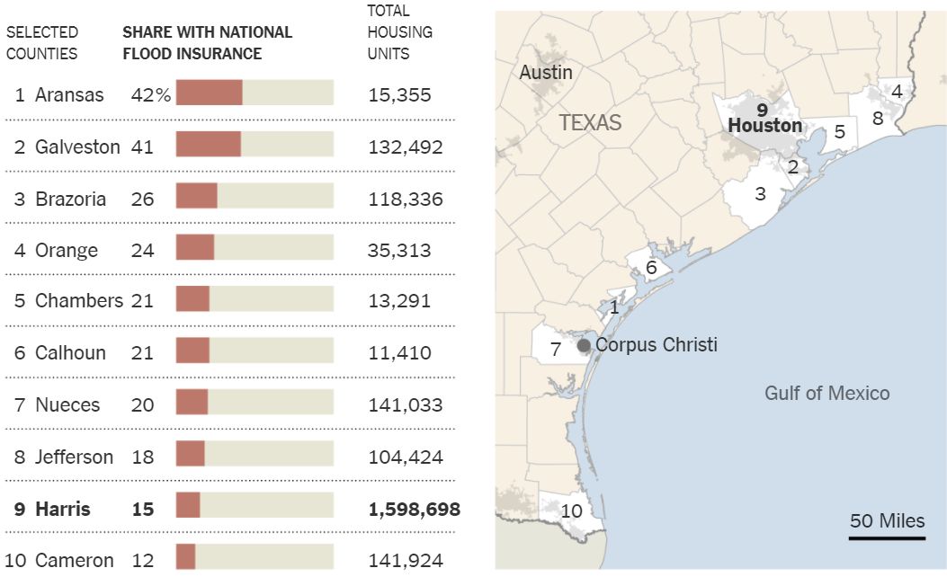
Share of homes with flood insurance in selected high risk coastal Texas counties as of August 2016, by Insurance Information Institute, published by The New York Times.
Houston, also known as "Bayou City" has a long history of such event. Sam Brody flood impact expert and professor in the department of marine sciences at Texas A&M University’s Galveston campus, commented in The Guardian: The Texas metropolis has more casualties and property loss from floods than any other locality in the US, according to data stretching back to 1960 that Brody researched with colleagues. And, he said: “Houston is number one and it’s not even close. [...] Houston is situated in a low-lying coastal area with poorly draining soils and is subject to heavy rainfall events and storm surge events, which makes it very prone to flooding.
Already, "after its founding in the 1830s [...] the inundations came again and again, with 16 major floods in the city’s first century." reminds The New-York Times. The Texas Tribune reminded more recent disasters: "In the 1990s, as the population in the watershed grew by 35 percent, two major floods hit the area — both considered “500-year” events, which should have just a 1 in 500 chance of occurring in any given year. The back-to-back floods spurred a rowdy, beer-fueled gathering at a local Veterans of Foreign Wars hall in 1998 and, soon after, the formation of the Cypress Creek Flood Control Coalition. The hope was to curb further development, or encourage more responsible development, to help prevent flooding. But little changed, even after another major storm crippled Cypress and the Houston region just three years later — one that scientists say should have served as a wake-up call. In June 2001, Tropical Storm Allison dumped almost 40 inches of rain on the city in five days, flooding 73,000 residences and 95,000 vehicles. Twenty-two people died, and damage from the storm was more than $5 billion in Harris County. Allison was a shock not just because of the extent of flooding but also where it occurred — almost half of the buildings that flooded were outside floodplains designated by FEMA."
The Los Angeles Times quoted "Robert Bea, a member of the National Academy of Engineering and UC Berkeley emeritus civil engineering professor who has studied hurricane risks along the Gulf Coast. The city’s flood system is supposed to protect the public from a 100-year storm, but Bea calls that “a 100-year lie” because it is based on a rainfall total of 13 inches in 24 hours. “That has happened more than eight times in the last 27 years,” Bea said. “It is wrong on two counts. It isn’t accurate about the past risk and it doesn’t reflect what will happen in the next 100 years.” [...] In an average year, Houston gets 50 inches of rain — as much as Harvey will deliver to some parts of the city. [...] Dams along the rivers were built mainly for water storage, not flood control. Because Texas is so flat, the dams can’t hold much water, unlike western dams that are built in deep gorges.".
A worsening factor is the land subsidence that strikes Houston area. The Houston Chronicle states: "parts of Harris County have dropped between 10 and 12 feet since the 1920s, according to data from the U.S. Geological Survey.". The Los Angeles Times quoted: "Shuhab Khan, a geologist at the University of Houston, has documented that some areas of Houston are sinking at up to [5.5 cm] per year, a rapid rate in geological terms. While some of the subsidence is caused by natural movements of salt deposits, Khan said that most is the result of pumping oil and water from under the city. So far, it appears some of the hardest-hit flooded areas, such as the Jersey Village nieghborhood, are also the ones affected by subsidence, he said."
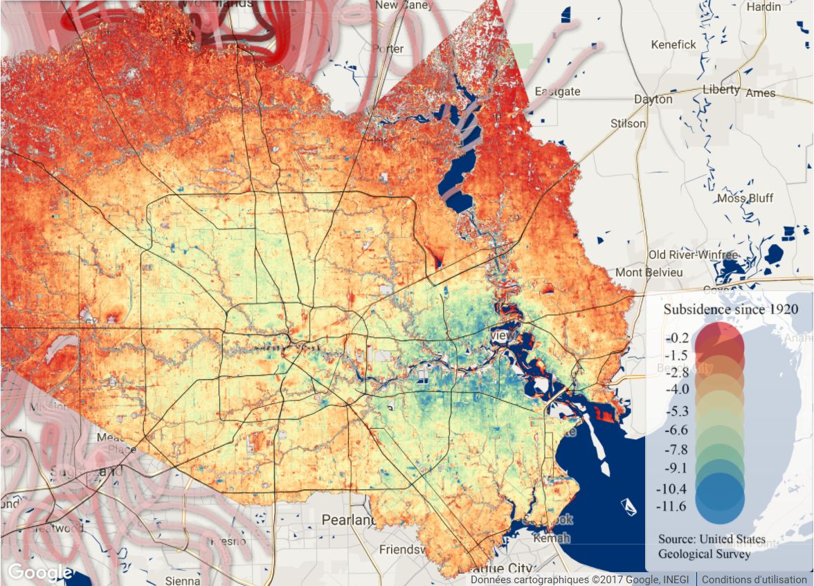
Map of Harris County subsidence since 1920, by John D. Harden from USGS, published by Houston Chronicle.
However, the biggest long-term problem is the city’s rampant growth and urbanization.
The Guardian reminds: "In 2000, 4.7 million people lived in the Houston metropolitan area. Now the population is about 6.5 million. [...] It is a worrying vision of the future: stronger and more frequent storms with fewer natural barriers, while rapid and haphazard urban development with limited oversight creates new at-risk zones or worsens drainage in known problem areas.".
The New-York Times commented: "".
Though its breakneck development culture and lax regulatory environment have been lauded for giving working people affordable housing — and thus a shot at the American dream — many experts and residents say that the developers’ encroachment into the wetlands and prairies that used to serve Houston as natural sponges has inevitably exacerbated the misery that the city is suffering today. “There could have been ways to have more green space and more green infrastructure over the years, and it just didn’t work that way, because it was fast and furious,” said Phil Bedient, a civil and environmental engineering professor at Rice University. Many developments were not built with enough open land or enough detention areas to take in floodwaters, Dr. Bedient said. “It’s been known for years how to do it,” he said, “it just costs the developers more money to do it that way.”
Greater Houston has always been a precarious place for a boomtown. It sprawls across a flat coastal plain, crisscrossed by slow-moving bayous, with clay soils that do not easily absorb water. Yet through all of this, metropolitan Houston has kept growing. Though the region suffered some tough years after the 1980s oil bust, Harris County, which includes Houston, experienced the highest annual population growth of any county in the United States in eight of the last nine years, according to census data. Developers both responded to and fueled the boom, often doing what they wanted in Texas’ relatively laissez-faire regulatory climate. In 2015, the Houston Chronicle examined a sampling of permits issued to developers, and found that more than half the developers had failed to follow through on Army Corps of Engineers directives meant to mitigate the destruction of wetlands. Two years ago, Erin Kinney, a research scientist with the nonprofit Houston Advanced Research Center, wrote that 65 square miles of freshwater wetlands had been lost in the Houston-Galveston Bay region, largely because of development and sinking land, and that 30 percent of Harris County was covered with impervious surfaces like roads, parking lots and roofs. The Texas Tribune write that: "in Harris County alone, research by Texas A&M scientist John Jacob shows, almost 30 percent of freshwater wetlands were lost between 1992 and 2010, a figure he calls “unconscionable.” As wetlands have been lost, the amount of impervious surface in Harris County increased by 25 percent from 1996 to 2011, Brody said.".
Don Riley, the former chief of the Army Corps of Engineers civil works division said to The Los Angeles Times>: "“It is naturally prone to flooding. People have built in this massive flood plain. They have to understand that.". The Corps and local officials have discussed ways to avert even greater risks by improving zoning, reducing the amount pavement to allow better drainage into the soil, building retention ponds in new housing developments and constructing new storm barriers. But when the Corps has tried to encourage land-use controls, the local reaction by politicians and developers has often been swift and furious, Riley said.
The Texas Tribune also recalls how past tries to changes policies were repelled : "When local politicians tried to change policies over development, they were met with stiff resistance from developers and residents. The city did pursue a law banning new development or major renovations of existing buildings in areas called floodways — the most vulnerable parts of the 100-year floodplain that are closest to the bayous. That prompted multiple lawsuits, and the law was ultimately severely weakened by the city council two years later. Still, said Bill White, who was mayor at the time, “It was the most aggressive action that had ever been taken” against such development. When White’s successor, Annise Parker, tried to impose a fee on city residents to pay for drainage improvements, lawsuits followed, too. The proposed fee remains in limbo. [...] Even with the new flood maps, development has continued in the 100-year floodplains. Since 2010, more than 7,000 residential buildings have been built in these risky areas in Harris County.".
Finally, many fear the impact of climate change in the Bay of Mexico. Quoted in The Guardian, Sam Brody said: "The climate is changing. In Galveston Bay the sea level is rising. We know the area is experiencing more heavy downpours”".
The views expressed herein can in no way be taken to reflect the official opinion of the European Space Agency or the European Union.
Contains modified Copernicus Sentinel data 2026, processed by VisioTerra.
Contains modified Copernicus Sentinel data 2026, processed by VisioTerra.
| More on European Commission space: |  |
 |
 |
||||
| More on ESA: | |
|
|
S-1 website | S-2 website | S-3 website | |
| More on Copernicus program: | |
|
|
Scihub portal | Cophub portal | Inthub portal | Colhub portal |
| More on VisioTerra: | |
|
|
Sentinel Vision Portal | Envisat+ERS portal | Swarm+GOCE portal | CryoSat portal |