Amazon fires
Sentinel-1 CSAR IW acquired on 21 August 2019
Sentinel-2 MSI acquired on 22 August 2019
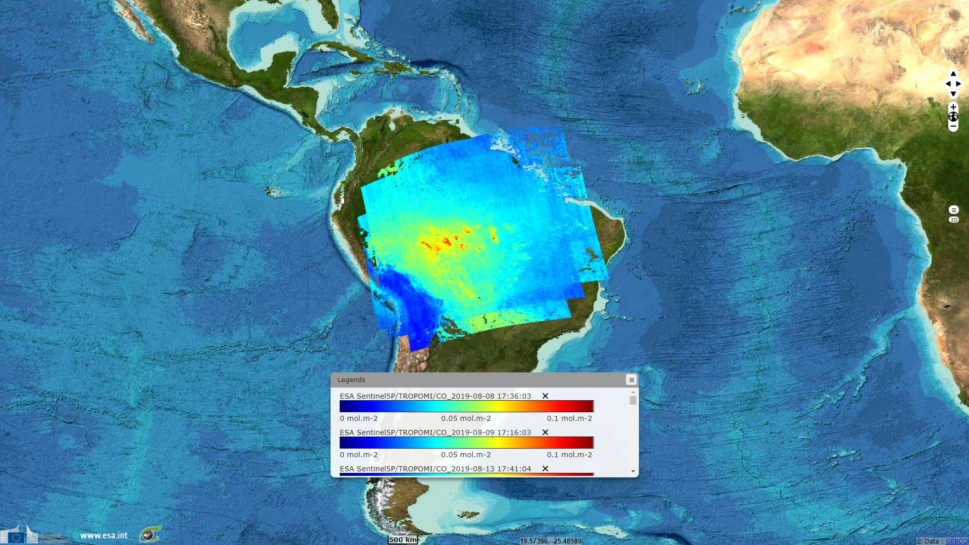
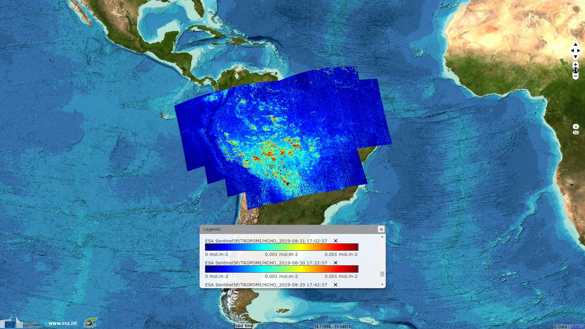
Sentinel-5P TROPOMI CO acquired on 08 August 2019, 09 August 2019, 13 August 2019, 15 August 2019, 19 August 2019, 20 August 2019, 26 August 2019, 29 August 2019, 30 August 2019, 03 September 2019 and 04 September 2019
Sentinel-2 MSI acquired on 22 August 2019
Sentinel-5P TROPOMI CO acquired on 08 August 2019, 09 August 2019, 13 August 2019, 15 August 2019, 19 August 2019, 20 August 2019, 26 August 2019, 29 August 2019, 30 August 2019, 03 September 2019 and 04 September 2019
Keyword(s): Fire, Amazon, Carbon
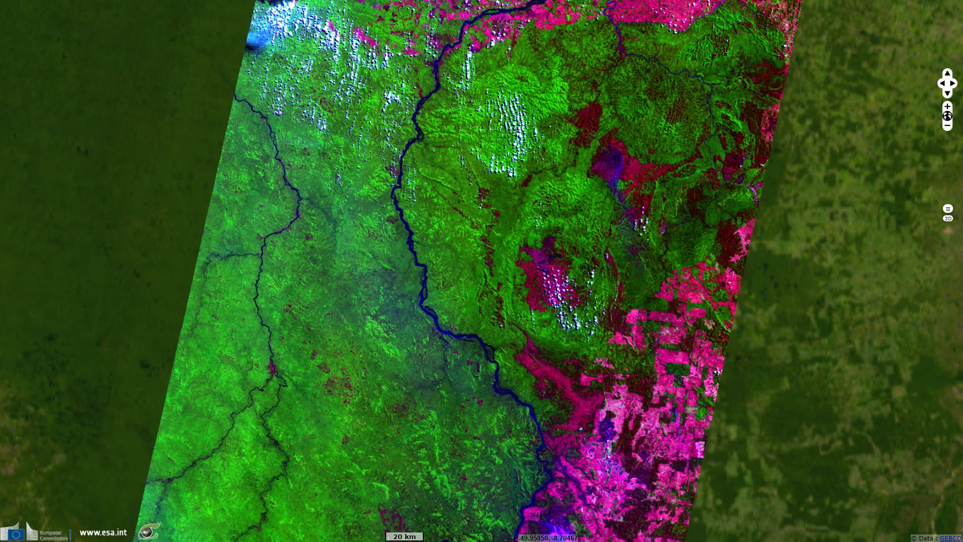
The colour composite shown in Fig.1 highlights agricultural areas in magenta, burnt areas in dark brown, and bare soil in light brown.
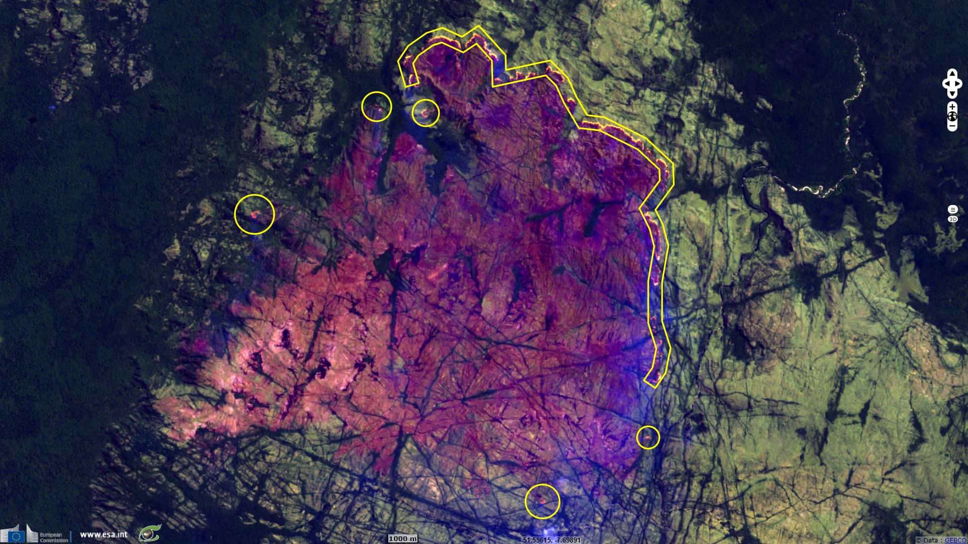
Fig.2 shows a a colour composite in which the active fires are visible and the blue band (band 2) makes it possible to distinguish the fumes and reveals the burned areas in dark brown.
Surface winds data are accessible and demonstrates that the front of the fires upwind the wind direction.
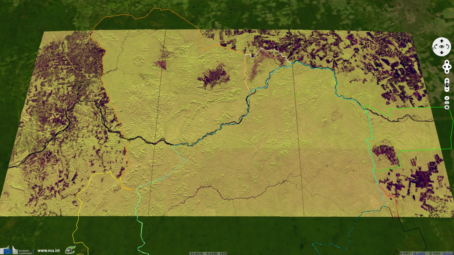
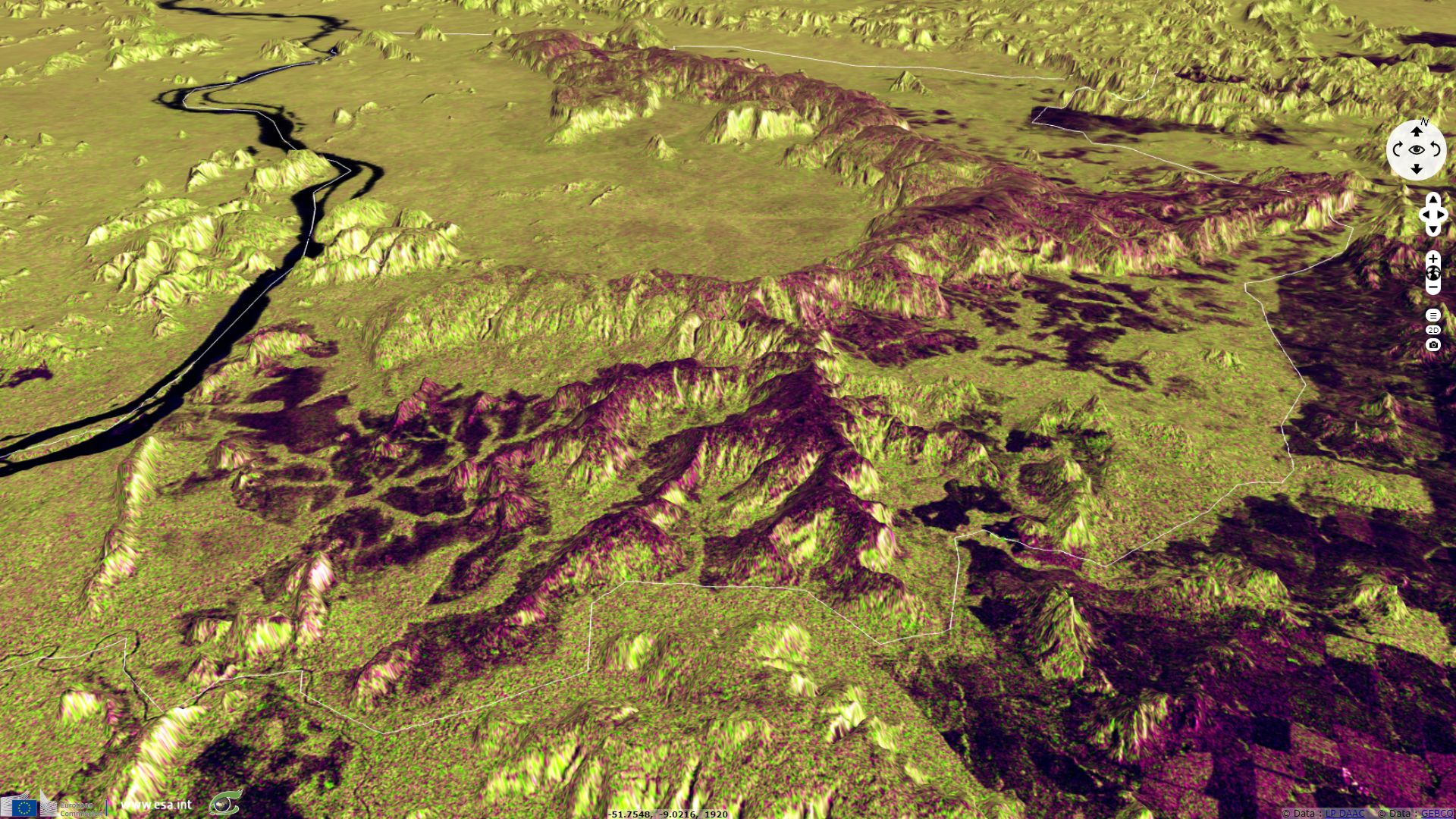
Fig.3 and Fig.4 show that the burned areas are mainly located on the hills and plateau areas.
These fires are an example of fires now burning in Brazil’s Amazon. According to Daniel Nepstad, Executive Director of the Earth Innovation Institute "the biggest threat to the Amazon forest is large-scale displacement by scrub vegetation driven by increasingly frequent extreme drought events and associated forest fire. During years of normal rainfall, the Amazon forest extends like a giant firebreak across the landscape. Fires set by landholders to improve grass cover in cattle pastures or to burn felled trees in preparation for crops or pasture are usually extinguished when they reach the floor of neighboring forests, where the damp layer of leaves, twigs and branches in the forest’s deep shade does not readily burn. But that same fire resistance of the forest is lost during years of severe drought, when the forest’s fuel layer dries out. And when the fuel layer catches fire, the likelihood of another fire becomes greater, as we explain below. As the forest burns repeatedly, grasses invade, and a once fire-resistant forest can be replaced by fire-prone scrub vegetation, as we described recently for our long-term forest fire experiment in Mato Grosso".
The Instituto Nacional de Pesquisas Espaciais (INPE) operates all Amazon forest cover change monitoring programs using satellites data from the year 1988. "This work became known as the legal Amazon Deforestation Project (PRODES), established under the Amazon Monitoring Program (AMZ). PRODES program, which provides annual estimates for the rate of deforestation in the Brazilian Amazon, is now the primary source of information for the decisions of the federal government and the policies to combat deforestation in the Amazon. The annual rates are estimated from the increments of deforestation identified in each satellite image that covers the Amazon. The first presentation of the data is made for December of each year as an estimate. Consolidated data are presented in the first half of the following year. PRODES uses LANDSAT class satellite imagery (20 to 30 meters of spatial resolution and 16-day revisit rate) in a combination that seeks to minimize the problem of cloud cover and ensure interoperability criteria . The LANDSAT-5 / TM American satellite images were historically the most used by the project, but the CCD sensor images aboard the CBERS-2 / 2B, satellites of the Sino-Brazilian remote sensing program, were widely used. PRODES also made use of LISS-3 images from the Indian IRS-1 satellite and also from the UK-DMC2 English satellite images. Currently making massive use of LANDSAT 8 / OLI, CBERS 4 and IRS-2 images. PRODES estimates are considered reliable by national and international scientists ( Kintish, 2007 ). Recent results, based on analyzes performed by independent experts , indicate an accuracy level close to 95%".
The annual PRODES deforestation rate "has been used as an indicator for proposing public policies and for evaluating the effectiveness of their implementations. PRODES spatial data are used in: (a) Certification of agribusiness production chains such as the Soy Moratorium and the Beef Cattle TAC Conduct Adjustment Term; (b) Intergovernmental agreements such as the United Nations Conference on Climate Change (COP 21) and National Inventory Reports on Greenhouse Gas Emissions; and (c) Monetary Donations from the Amazon Fund, which use PRODES as a reference to deforestation activity in the Legal Amazon. The forest state monitoring data transparency policy adopted by INPE and the federal government since 2004 allows full access to all data generated by the monitoring systems , enabling independent evaluations by the user community, including the government at their own levels, to be carried out. Brazilian academia, the citizen, and civil society in their various institutional arrangements.
The PRODES project has the collaboration of the Ministry of Environment (MMA) and the Brazilian Institute of Environment and Renewable Natural Resources (IBAMA) and is part of the Ministry of Science, Technology, Innovations and Communications (MCTIC) in the Group. Permanent Interministerial Working Group to Reduce Legal Amazon Deforestation Rates, created by Presidential Decree of 3 July 2005. The GTPI is part of the Action Plan for the Prevention and Control of Legal Amazon Deforestation, launched on March 15. 2004".
In the INPE portal (TerraBrasilis) users will be able to follow deforestation data in a more modern and friendly way. A dashboard was built, that is, an interactive data visualization panel, where users can interact with several graphs that show the key aspects to analyze the deforestation rate in the whole area observed or filtered by municipalities, states, units. conservation etc. The user still has the possibility to obtain the data in common formats, allowing the construction of their own graphs and analysis.
Dalton Valeriano, INPE's Amazon Program coordinator says " With this new form of presentation we believe that managers, such as mayors and governors, as well as journalists, students, researchers, and the general population, gain access to their compiled, up-to-date, and easily presented data directly in the environment".
Karine Ferreira, technologist of INPE, responsible for the technological part of the portal's modernization explains "For this new way of making PRODES data available, we have adapted a set of open technologies for the construction of geographic portals, inserting some new features and modifying others, building a dissemination platform that we call TerraBrasilis".
Herein some data showing the deforestation in the Para state showed in Fig.1 to Fig.4. One may see that the state Para is the most state affected by deforestation in Brasil.
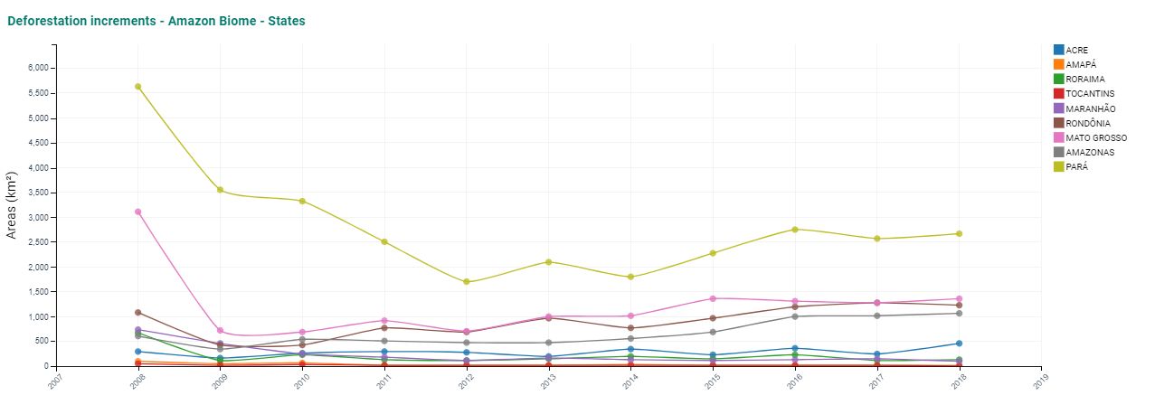
Deforestation by state in Brasil - Source: Terrabrasilis.
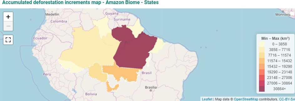
Deforestation by state in Brasil - Source: Terrabrasilis.
The views expressed herein can in no way be taken to reflect the official opinion of the European Space Agency or the European Union.
Contains modified Copernicus Sentinel data 2026, processed by VisioTerra.
Contains modified Copernicus Sentinel data 2026, processed by VisioTerra.
| More on European Commission space: |  |
 |
 |
||||
| More on ESA: | |
|
|
S-1 website | S-2 website | S-3 website | |
| More on Copernicus program: | |
|
|
Scihub portal | Cophub portal | Inthub portal | Colhub portal |
| More on VisioTerra: | |
|
|
Sentinel Vision Portal | Envisat+ERS portal | Swarm+GOCE portal | CryoSat portal |