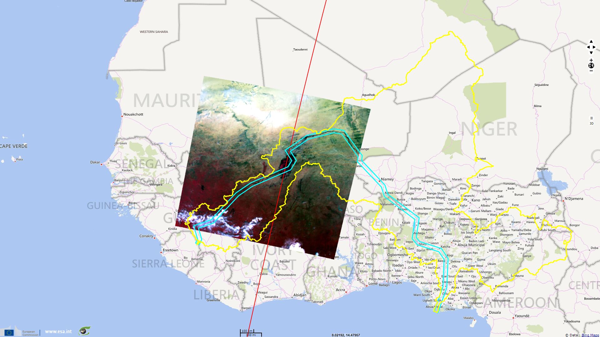
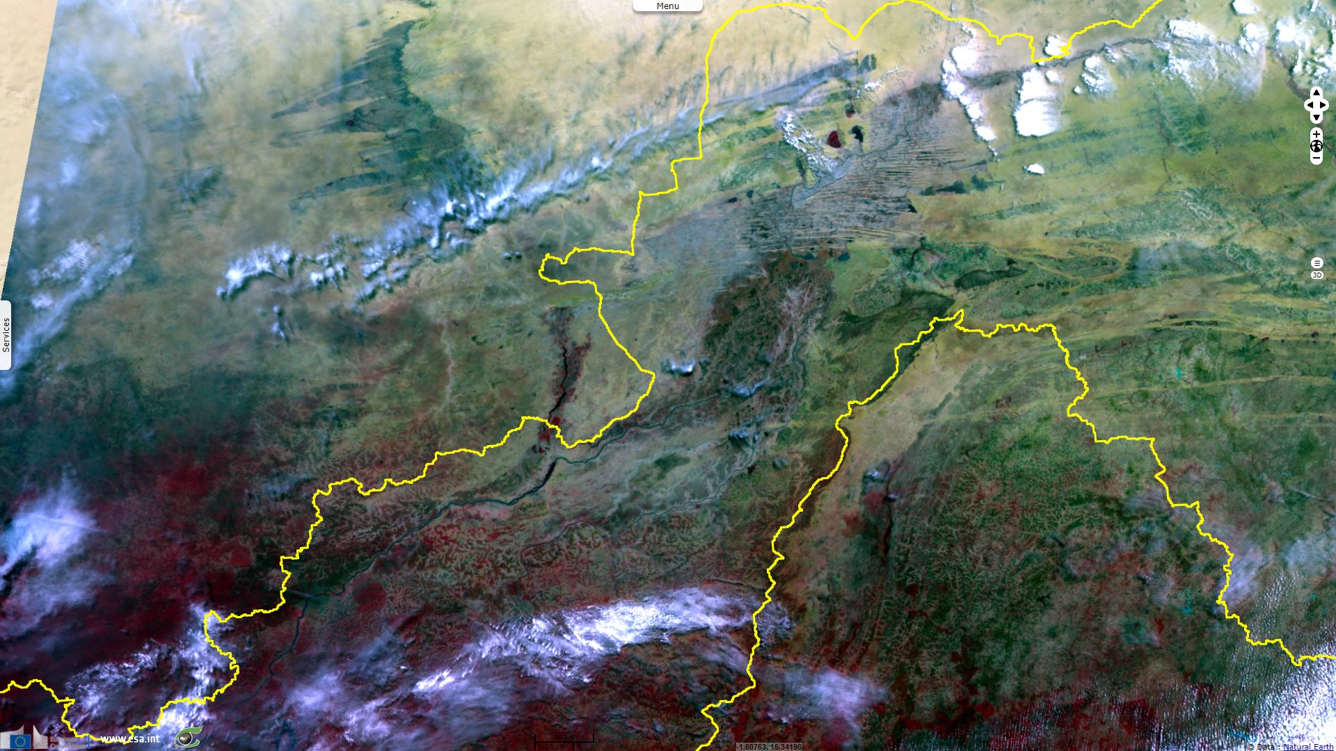
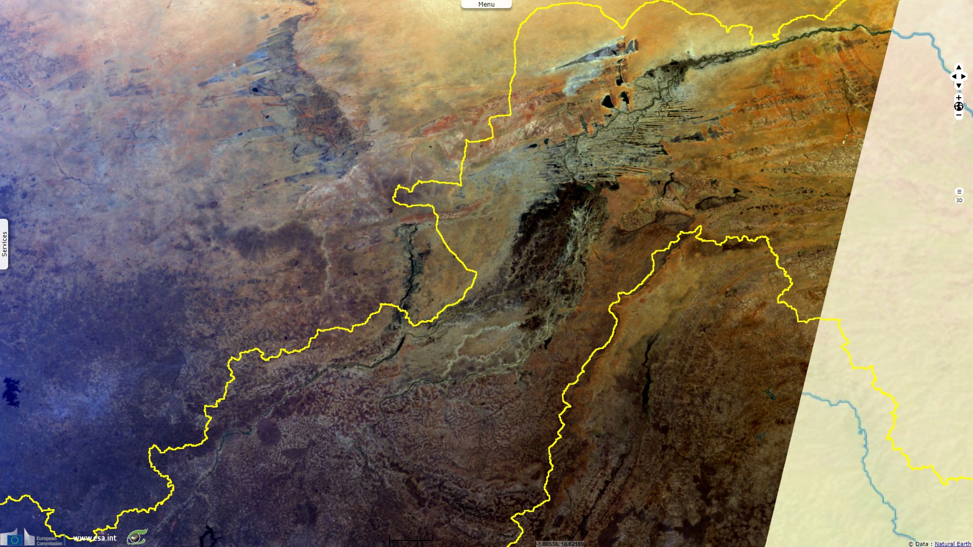
Inner Niger Delta animated by S3A acquisitions
Sentinel-3 OLCI FR acquired on 27 October 2016 at 10:18:06 UTC
Sentinel-3 SRAL LAND acquired on 15 November 2016 at 10:06:40 UTC
...
Sentinel-3 OLCI FR acquired on 04 August 2017 at 10:33:05 UTC
Sentinel-3 SRAL LAND acquired on 15 November 2016 at 10:06:40 UTC
...
Sentinel-3 OLCI FR acquired on 04 August 2017 at 10:33:05 UTC
Keyword(s): land, hydrology, lake, floodplains, swamp, wetland, inner delta, Ramsar, Niger river, Mali
The FAO describes Niger River, writing "with a total length of about 4100 km, is the third-longest river in Africa, after the Nile and the Congo/Zaire Rivers, and the longest and largest river in West Africa." While the source of the Niger lies only 240 km from the Atlantic Ocean, it takes a much longer crescent shape course to join it. Niger runs north, crosses the Sahel following a north-east course, runs into the Sahara in Mali, then sharply turns south-east in Sahelian Niger and finally end flowing south to the Gulf of Guinea
"The quantity of water entering Mali from Guinea (40 km3/yr) is greater than the quantity of water entering Nigeria from Niger (36 km3/yr), about 1800 hen further downstream. This is due among other reasons to the enormous reduction in runoff in the inner delta in Mali through seepage and evaporation combined with almost no runoff from the whole of the left bank in Mali and Niger.
Average discharges of the Niger River and its main tributaries
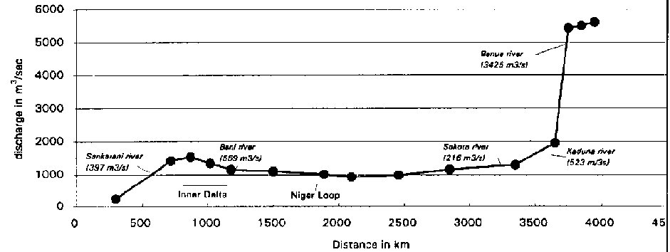
The most important areas of the Niger basin are located in Mali, Niger and Nigeria (25 % in each of these three countries). Mali and Niger are almost entirely dependent on the Niger River for their water resources. In the case of Niger nearly 90% of its total water resources originates outside its borders (the Niger River and other tributaries from Burkina Faso and Benin)."
The Inner Niger Delta water regime is highly variable, the intra year water flow above the delta is estimated by Global Runoff Data Centre as varying between 50 m3/s (May during the dry season) to 4200 m3/s (September during the wet season). In Fonctionnement hydrologique de la cuvette lacustre du Niger et essai de modélisation de l'inondation du Delta intérieur, J.C. Olivry estimates the inter year variation of the maximum flooded area between 7000 km² to 35000 km². Temporal variations between flooded, vegetated and dry area can be assessed using satellite images.
According to the FAO, "the total area covered by the inner delta, which is a network of tributaries, channels, swamps and lakes, can reach about 30000 km2 in flood season. The delta area is swampy and the soil sandy. Consequently, the river 'loses' nearly two-thirds of its potential flow between Ségou (at 900 km from its source) and Timbuktu (at 1500 km) due to seepage and evaporation, the latter being aggravated by the fact that the river here touches the southern flanks of the Sahara desert. All the water from the Bani tributary, which flows into the Niger River at Mopti (at 1150 km), does not compensate for the 'losses' in the inner delta, as the total flow further downstream still decreases rather than increases. The average 'loss' is estimated at 31 km3/year, but varies considerably according to the years".
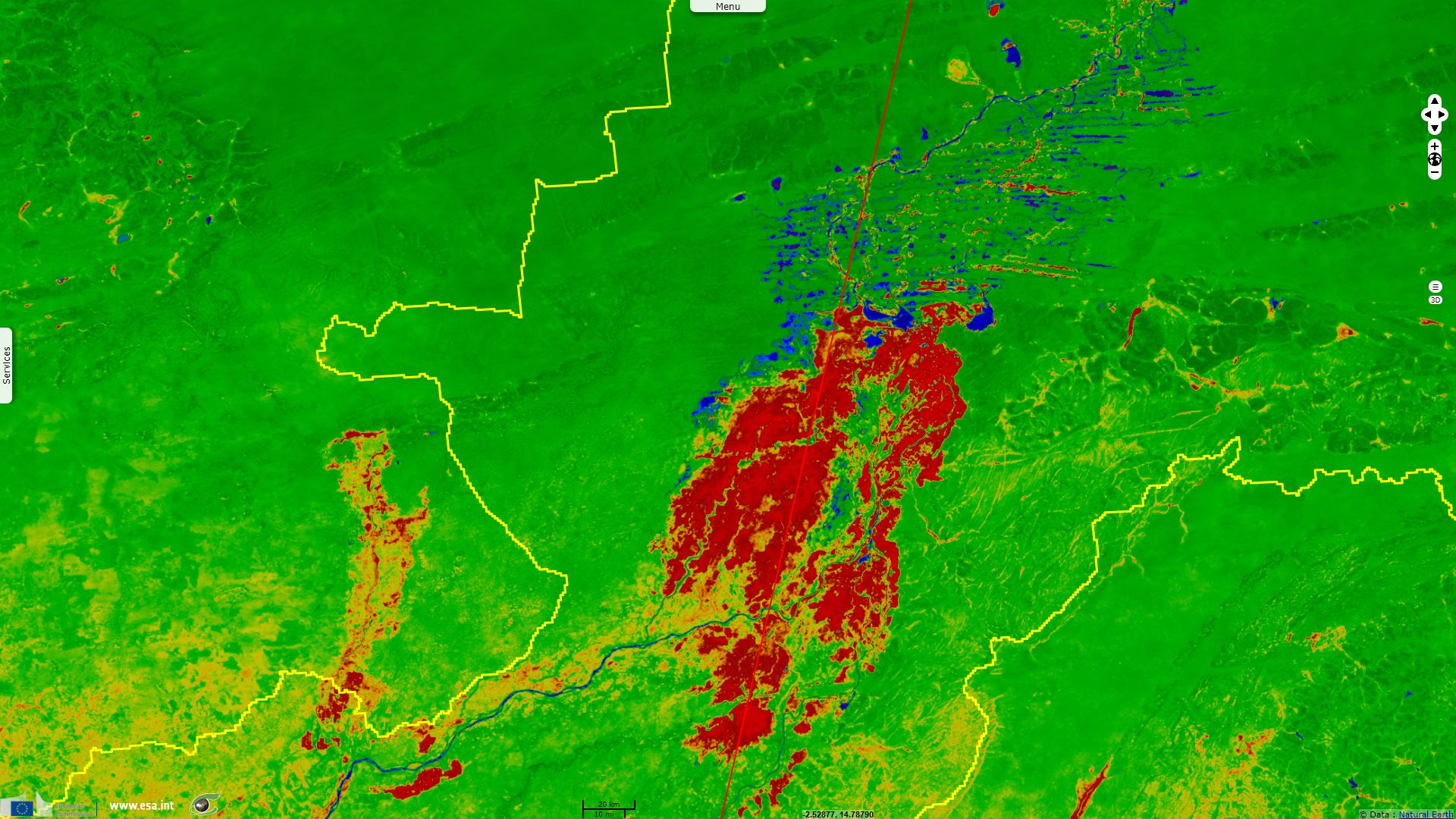
Inner Niger Delta is a 40000 km² Ramsar site, it is considered as an important ecosystem: "A vast floodplain situated in the middle of sahelian landscape, rich in natural resources and featuring varied ecosystems (lakes, forest floodplains, flooded grasslands and savannah). It is the largest inland wetland in West Africa and the second largest wetland in Africa, after the Okavanga Delta in Botswana. It supports an exceptionally high number of animal and plants species and is a refuge for many migratory birds, hosting more than 350 species, with 103 waterfowl species listed between 1998 and 2001. Each year more than 1 million birds come from more than 80 countries to use the delta." It hosts species such as the ibis, crane, heron, stork, cormorant, hippopotamus, crocodile, varan, cobra, viper, python, tortoise and many amphibians.
This resource of water and vegetation in semi arid to arid area had a strong impact on human implantation, Ramsar states: "The Inner Niger Delta is the source of the emergence of the big empires of the 8th to 16th centuries (Ghana, Mali, Songhoy), then of the theocratic States of Sékou, Ahmadou and Elhadj Omar Tall. Numerous historic cities like Hamdallayi (ancient capital of the Dina), Djenné, Dia and Bandiagara are important economic, political and cultural centers today. The historic city of Djenné and the cliffs of Bandiagara have been on UNESCO's World Cultural and Natural Heritage lists since 1989."
Despite its Ramsar site status, the Inner Niger Delta ecosystem is threatened by dam building, crop irrigation projects as as well as over-grazing and overfishing. "Nearly one million people live on the resources of the delta ecosystems, by agriculture, farming, fishing, crop, navigation, tourism, etc." To meet these challenges, the Niger Basin Authority has elaborated an Action Plan for the Sustainable Development of the Niger Basin: "The Niger Basin, a shared region of sustainable development achieved through the comprehensive, integrated management of water resources and their associated ecosystems, to improve everyday living standards and prosperity by 2025."
The views expressed herein can in no way be taken to reflect the official opinion of the European Space Agency or the European Union.
Contains modified Copernicus Sentinel data 2026, processed by VisioTerra.
Contains modified Copernicus Sentinel data 2026, processed by VisioTerra.
| More on European Commission space: |  |
 |
 |
||||
| More on ESA: | |
|
|
S-1 website | S-2 website | S-3 website | |
| More on Copernicus program: | |
|
|
Scihub portal | Cophub portal | Inthub portal | Colhub portal |
| More on VisioTerra: | |
|
|
Sentinel Vision Portal | Envisat+ERS portal | Swarm+GOCE portal | CryoSat portal |