La Réunion, witness to a volcanic hotspot
Sentinel-1 CSAR EW acquired on 11 March 2018 at 01:46:13 UTC
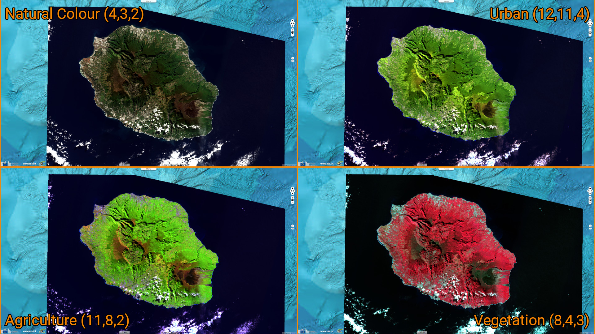
Sentinel-2 MSI acquired on 16 July 2018 at 06:35:11 UTC
Sentinel-1 CSAR EW acquired on 17 January 2021 at 14:52:34 UTC
Sentinel-2 MSI acquired on 03 October 2022 at 06:35:21 UTC
Sentinel-2 MSI acquired on 16 July 2018 at 06:35:11 UTC
Sentinel-1 CSAR EW acquired on 17 January 2021 at 14:52:34 UTC
Sentinel-2 MSI acquired on 03 October 2022 at 06:35:21 UTC
Keyword(s): Volcano, hotspot, geology, island, caldera, cirque, UNESCO World Heritage, France
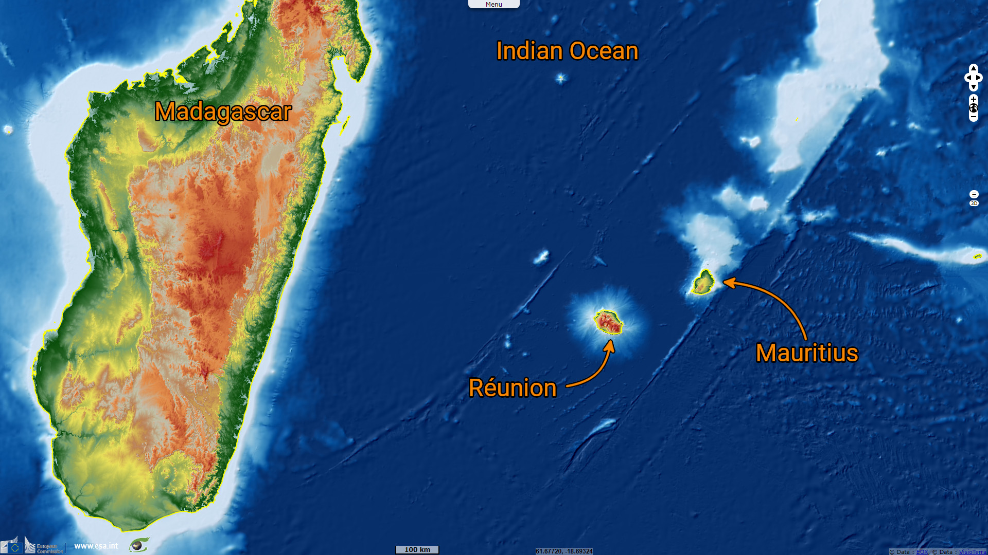
The Chagos-Laccadive Ridge and the southern part of the Mascarene Plateau are remains of the volcanic hotspot which lies under the Réunion.
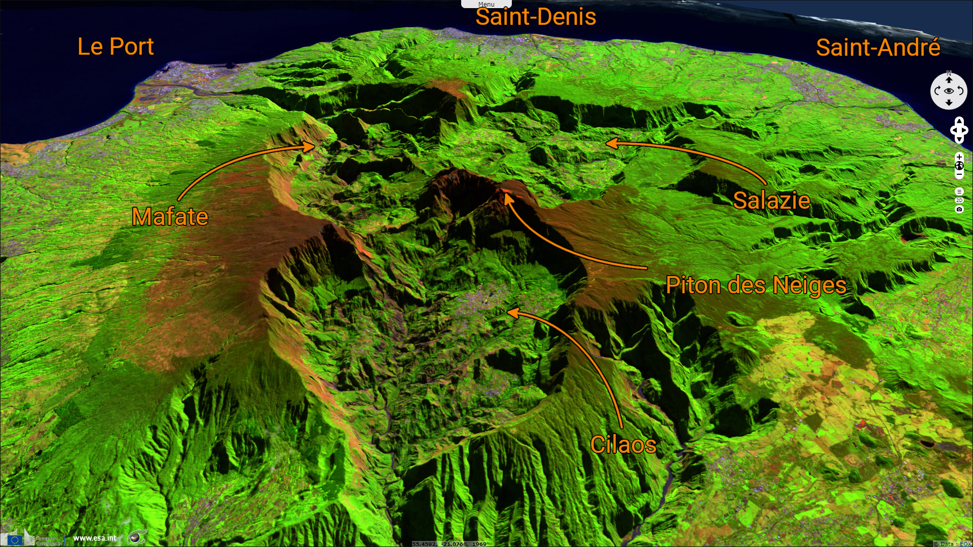
The Réunion island is composed of two volcanoes, the Piton des Neiges at the northwest part (visible here) and the Piton de la Fournaise at the southeast part. The Piton des Neiges is the highest point on the island at 3070m above sea level.
"Collapsed calderas and canyons are south west of the mountain. While the Piton de la Fournaise is one of Earth's most active volcanoes, the Piton des Neiges is dormant. Its name is French for "peak of snows", but snowfall on the summit of the mountain is rare. The slopes of both volcanoes are heavily forested. Cultivated land and cities like the capital city of Saint-Denis are concentrated on the surrounding coastal lowlands. Offshore, part of the west coast is characterised by a coral reef system. Réunion also has three calderas: the Cirque de Salazie, the Cirque de Cilaos and the Cirque de Mafate. The last is accessible only on foot or by helicopter." (source Wikipedia)
"Collapsed calderas and canyons are south west of the mountain. While the Piton de la Fournaise is one of Earth's most active volcanoes, the Piton des Neiges is dormant. Its name is French for "peak of snows", but snowfall on the summit of the mountain is rare. The slopes of both volcanoes are heavily forested. Cultivated land and cities like the capital city of Saint-Denis are concentrated on the surrounding coastal lowlands. Offshore, part of the west coast is characterised by a coral reef system. Réunion also has three calderas: the Cirque de Salazie, the Cirque de Cilaos and the Cirque de Mafate. The last is accessible only on foot or by helicopter." (source Wikipedia)
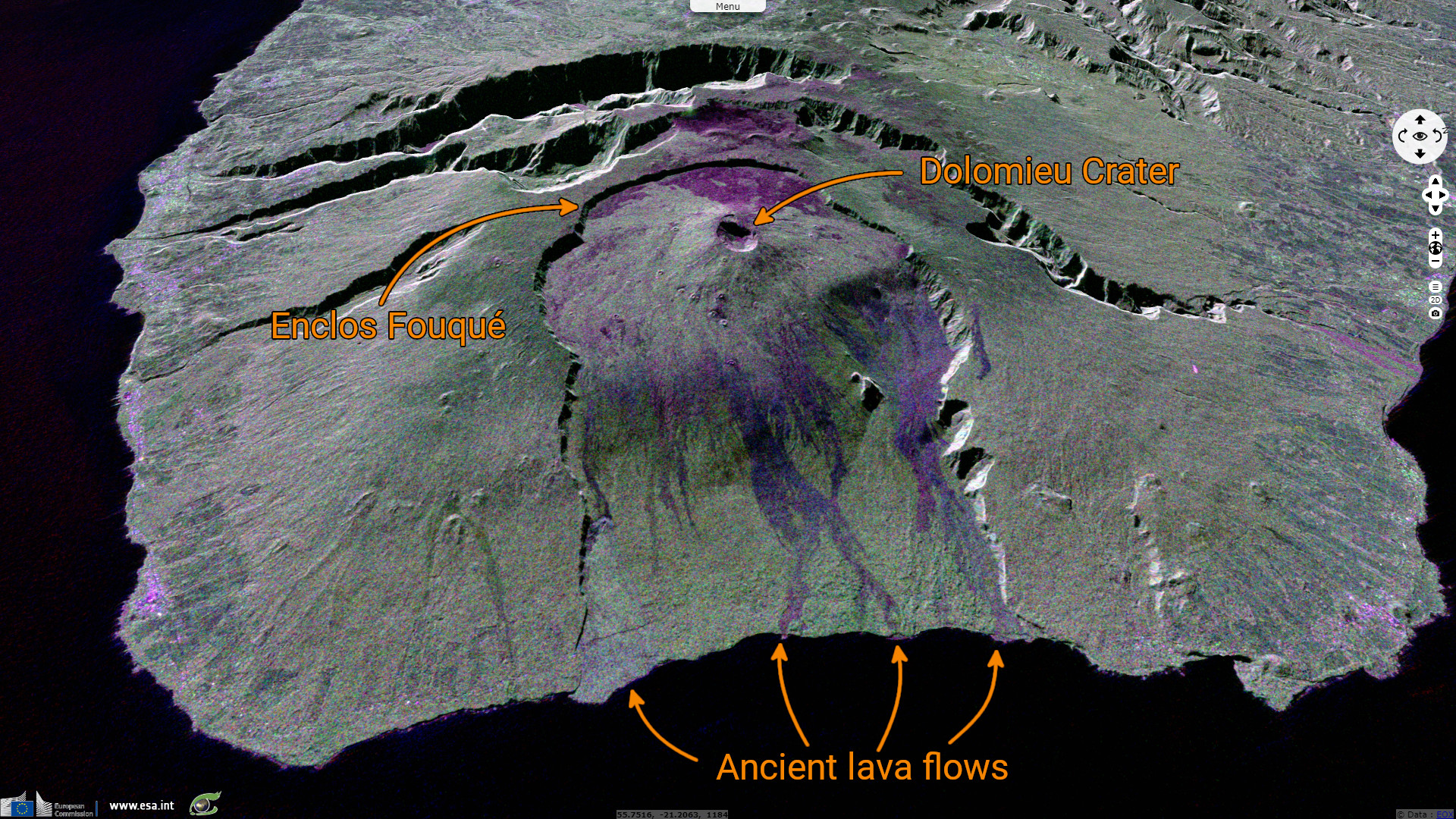
The southeast part of the island is dominated by the Piton de la Fournaise volcano which is still active and monitored. "The uppermost section of the volcano is occupied by the Enclos Fouqué, a caldera 8 kilometres wide. High cliffs, known as remparts in French, form the caldera's rim. The caldera is breached to the southeast towards the sea. Inside the caldera is a 400 metres high lava shield named Dolomieu. At the top of this lava shield are Bory Crater (Cratère Bory) and Dolomieu Crater (Cratère Dolomieu), which is by far the wider of the two and named for French geologist Déodat Gratet de Dolomieu." (source Wikipedia)
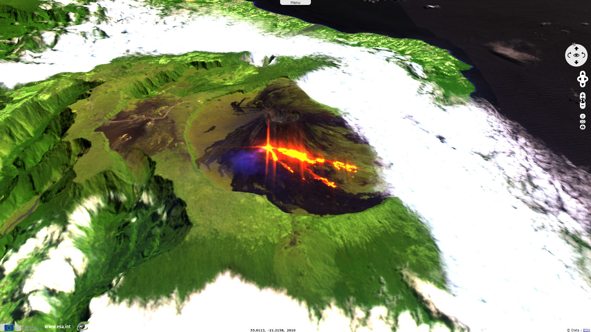
"In April 2007 the volcano erupted and produced an estimated 3,000,000 cubic metres of lava per day. During this eruption of 2007 an incremental caldera collapse of Dolomieu occurred at the volcano over more than nine days. The collapse displacing 0.8 x 1.1 km floor downward by 330 m, with a volume of 120 million cubic metres. The caldera collapse accompanied one of the largest eruptions of lava at the volcano in the past 100 years." (source Wikipedia)
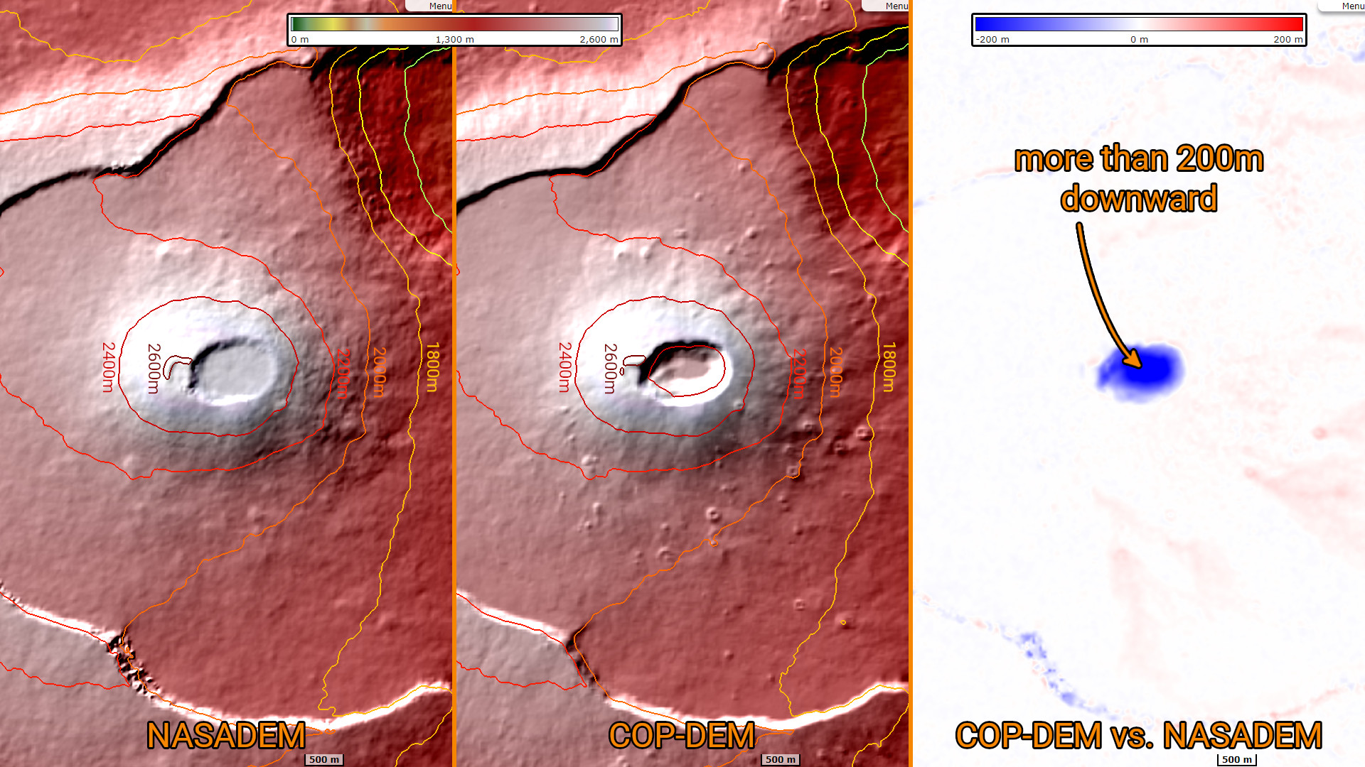
COP-DEM and NASADEM are both global Digital Elevation Model (DEM) at 1 arcsecond of resolution. Their differences lie first of all in the data used to generated them and their acquisition date. NASADEM is based on SRTM data acquired during the mission STS-99 in 2000 while COP-DEM is based on Tandem-X acquired from 2010 to 2015. This difference make it possible to see the collapse of the caldera that occured during the volcanic eruption of 2007.
The views expressed herein can in no way be taken to reflect the official opinion of the European Space Agency or the European Union.
Contains modified Copernicus Sentinel data 2026, processed by VisioTerra.
Contains modified Copernicus Sentinel data 2026, processed by VisioTerra.
| More on European Commission space: |  |
 |
 |
||||
| More on ESA: | |
|
|
S-1 website | S-2 website | S-3 website | |
| More on Copernicus program: | |
|
|
Scihub portal | Cophub portal | Inthub portal | Colhub portal |
| More on VisioTerra: | |
|
|
Sentinel Vision Portal | Envisat+ERS portal | Swarm+GOCE portal | CryoSat portal |