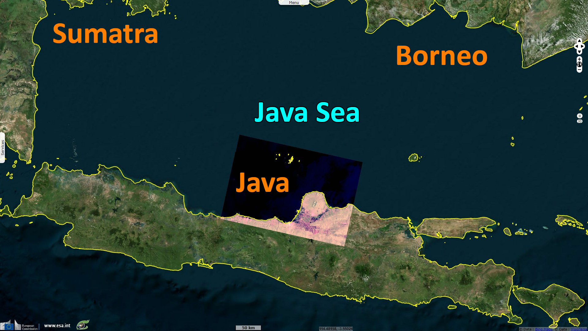
Villages along the coast of Java are sinking rapidly due to erosion, Indonesia
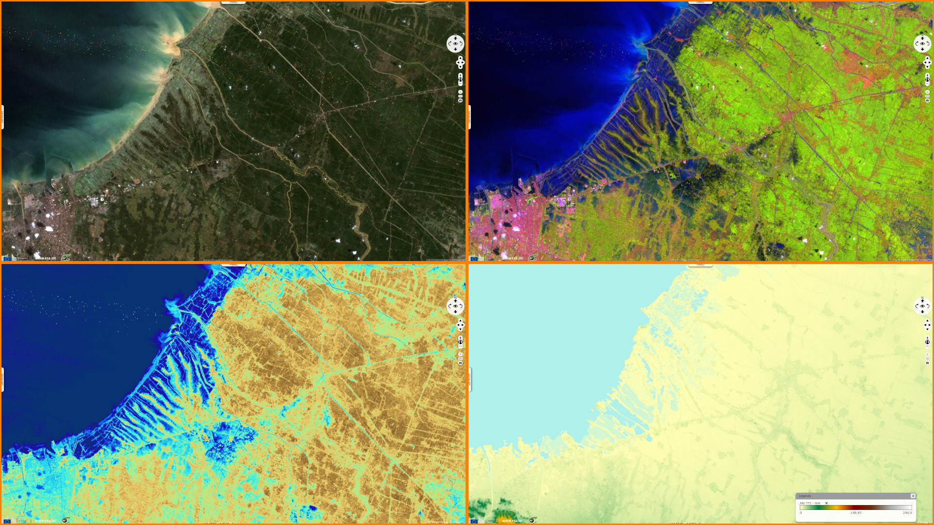
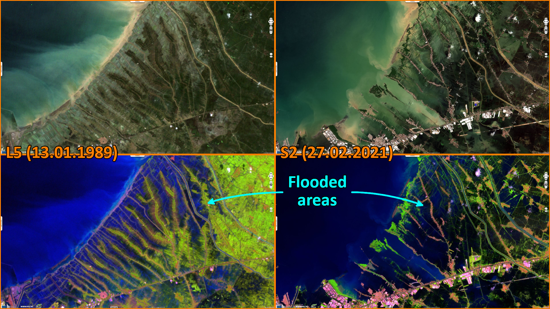
Landsat TM acquired on 13 January 1989 at 02:18:03 UTC
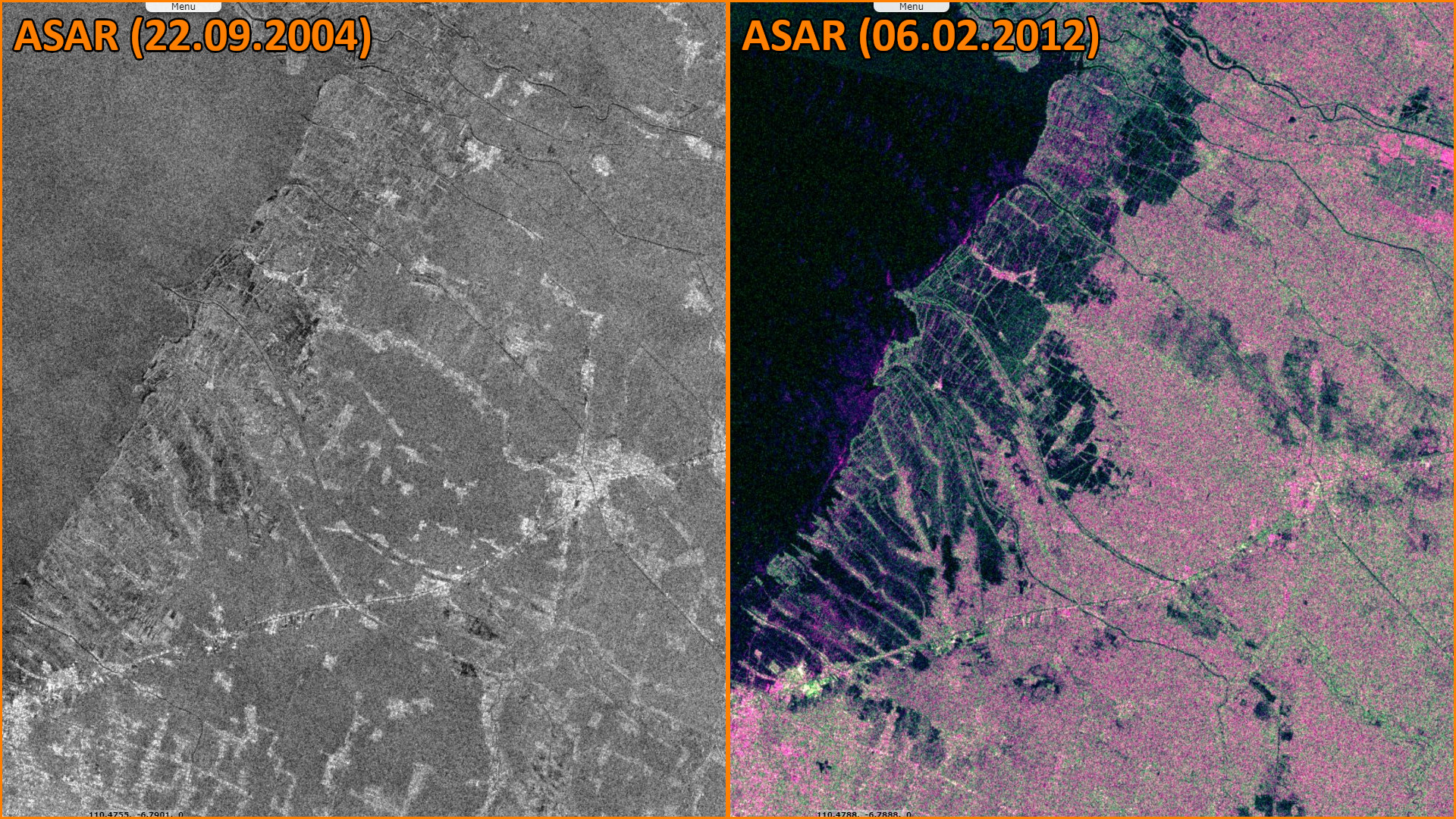
ENVISAT ASAR acquired on 22 September 2004
ENVISAT ASAR acquired on 06 February 2012
Sentinel-2 MSI acquired on 27 February 2021 at 02:36:41 UTC
Sentinel-1 CSAR IW acquired on 02 April 2023 at 22:17:35 UTC
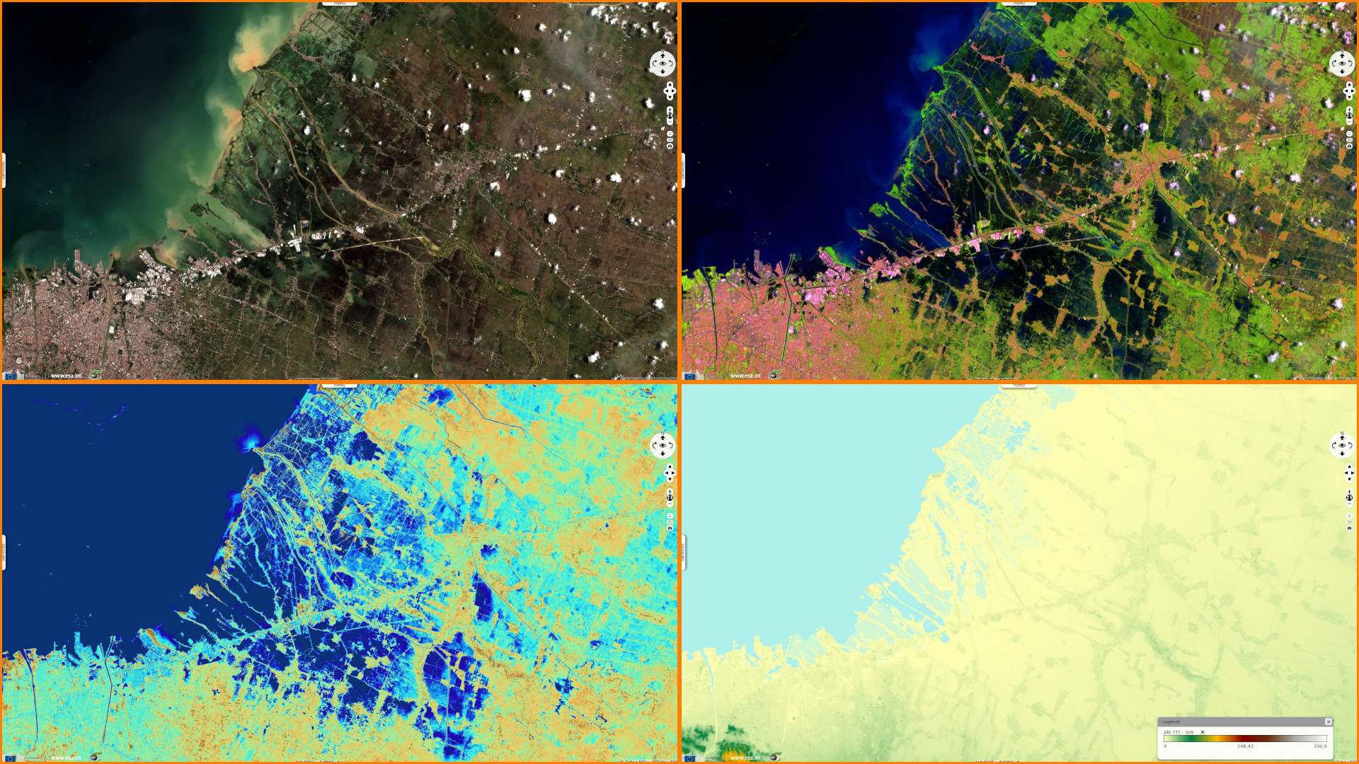
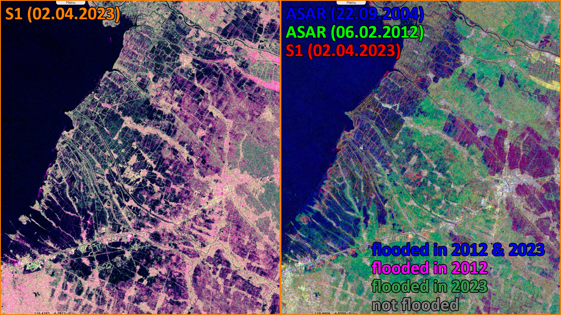
ENVISAT ASAR acquired on 22 September 2004
ENVISAT ASAR acquired on 06 February 2012
Sentinel-2 MSI acquired on 27 February 2021 at 02:36:41 UTC
Sentinel-1 CSAR IW acquired on 02 April 2023 at 22:17:35 UTC
Keyword(s): Coastal, erosion, subsidence, flooding, urban planning, infrastructure, Indonesia
Relative sea level (SLR) rise due to land subsidence constitutes a major coastal threat. Subsiding areas, such as along Java's northern coast, represent complex coastal geomorphologies and risk constellations. In 2018, Heri Andreas published in IntechOpen open peer-reviewed platform the article Insight into the Correlation between Land Subsidence and the Floods in Regions of Indonesia: "Land subsidence is quite a well-known phenomenon in some regions of Indonesia, especially around urban areas such as Jakarta, Bandung, and Semarang." "The impacts or consequences from land subsidence can be seen in several forms such as infrastructure damage, wider expansion of flood water, as well as tidal inundation (flooding by sea water at coastal areas experiencing land subsidence). In certain regions of Indonesia, the impact of land subsidence in the form of flooding and tidal inundation clearly exists."
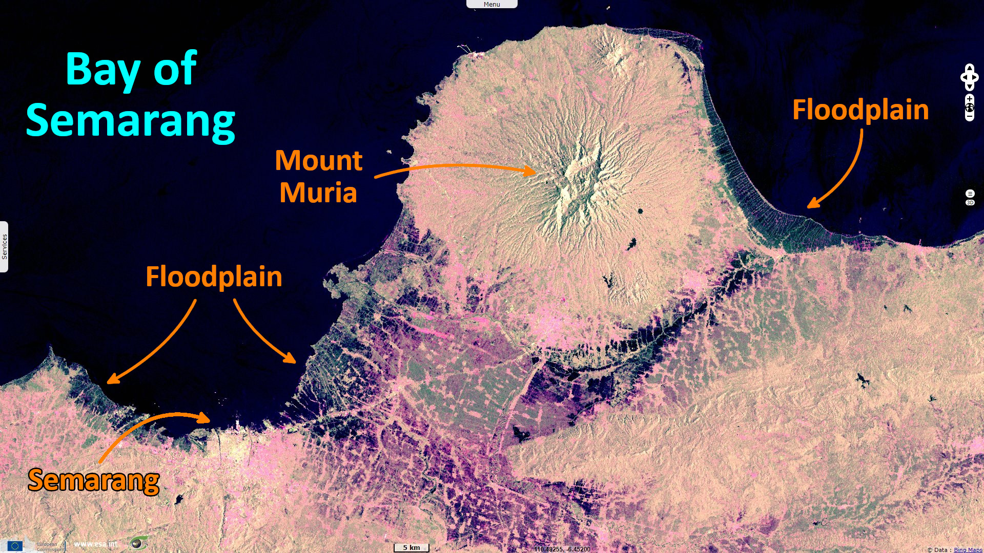
The coastal city of Semarang is the capital of Central Java province. Its population rose from 370 000 in 1950 to 1.7 million in 2022, an increase by a 4.5 factor. "Half of the city unfortunately is experiencing land subsidence, especially around the northeastern part.", adds Heri Andreas. The article Land Subsidence in Urban Areas of Indonesia written by Hassan Abidin and published in 2005 in GIM International independent media platform deals with the specific risk of this city:
"As a consequence of lowering land due to subsidence, this place is prone to either flooding from rainfall or flooding from the sea or tidal inundation." "Indeed, some parts of the area are permanently drowning as endorsed by analysis using the time series of high-resolution satellite image data. It is an undoubted fact of correlation between subsidence and flooding creating a real disaster. Sometime in the future this problem may worsen if we see a significant linear rate of subsidence in this area; on the other hand, attempts to mitigate or adapt to this situation are still not a priority."
Regarding the main causes of subsidence, Lisa-Michéle Bott explains in her article Land subsidence in Jakarta and Semarang Bay – The relationship between physical processes, risk perception, and household adaptation published in Ocean & Coastal Management in 2021: "Natural causes of subsidence, such as compaction of unconsolidated alluvial soils, oxidation of organic materials, earthquakes, glacial isostatic adjustments, and geological evolution of the underground, are often strongly amplified by human activities, such as land reclamation, excessive fluid extractions (e.g. ground water, natural gas, or crude oil), fracking and mining activities, and high surface loads from buildings and infrastructure. The highest subsidence rates, therefore, often correspond with densely populated coastal settlements, which is also evident in our study areas where human activities, especially ground water extraction, are the strongest driver of local subsidence rates. Because the sinking land becomes relatively lower towards the local sea level, this relative sea level rise strongly increases the local risk towards coastal flooding. Thus, subsidence is at its core a complex socio-environmental process and people in coastal urban areas are both drivers of and subject to this multi-dimensional hazard."
"The geological situation of Semarang is characterized by marine sediments and alluvial deposits along the coast but with volcanic rocks of the Damar formation in the South-West of Semarang City. Thus, the subsidence is limited to the northern and north-eastern parts of the city. The marine sediments mainly consist of clay with intercalation of sandstone layers, while the alluvial deposits consist of clay and sand with a thickness of more than 80 m."
"While Semarang, in its lower lying parts located on alluvial plains, shows a similarly high exposure towards land subsidence, the major flooding risk in Semarang City, however, are the daily high-tidal floods of the already low-lying areas. In case of heavy rainfall, the floods become even more destructive, since the water cannot drain off into the sea. Municipal plans here include the construction of an embankment-toll-road-structure parallel to the coastline. Nevertheless, high subsidence rates contest structural sea defense systems since every built structure further increases the surface load leading to higher subsidence and locks in water from the hinterland."
"In Semarang, subsidence has probably existed for over 100 years. First geodetic monitoring of subsidence is reported for a few sparse points from 1991 to 1996 revealing rates of up to 81 mm/a." Later measures, "based on levelling surveys conducted from 1996 to 2001, land subsidence rates were calculated at about 17 cm per year", reports Hassan Abidin. He adds: "The number of registered groundwater-extraction wells rose from 181 in 1994 to 1029 in 2000. The volume of extracted groundwater increased from 23 million m3 in 1990 to 38 million m3 in 2000."
According to the work of Lisa-Michéle Bott: "Relative SLR due to land subsidence tends to show significantly higher rates (currently up to 12 cm/a in Northern Jakarta) than the global geocentric SLR driven by, e.g. processes of global warming (~3.2 mm/a). As an example, within just five years, the megacity Jakarta will experience a relative SLR (at selected spots) similar to the expected cumulative global mean SLR over the next 80 years."
Heri Andreas finds subsidence "rates of about 1–20 centimeters per year can be found at these regions from geodetic measurements such as Global Navigation Satellite System Global Positioning System (GNSS GPS) surveys, InSAR, and leveling. After some decades a magnitude of 3–4 meters of subsidence has taken place in Jakarta and Bandung, and probably in other unsurveyed areas." "Our analysis of InSAR, radar altimetry, and corrected tide gauges clearly identifies subsidence as the major coastal threat in our study areas. The InSAR analysis for Semarang shows stable trends of subsidence up to ~100 mm/a."
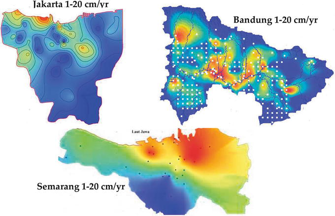
"Map of land subsidence in Jakarta, Bandung, and Semarang. Highest rate of 20 centimeters per year is represented by the red color. North Jakarta and northeastern Semarang areas are experiencing the highest rate. Meanwhile the highest rate in the Bandung area is in the industrial areas) - Source: Heri Andreas."
Regarding the impact on local population, Lisa-Michéle Bott concludes: "We found, that in contrast to fast-onset events, constantly proceeding subsidence becomes normalized in peoples’ perceptions and responses are integrated into day-to-day habits. Thus, risk perception is a far lesser determinant of responses towards subsidence than it is for fast-onset events. Hence, our results relativize former assumptions that risk perception and not actual exposure lead to action. Moreover, we found that local people are not willing to vacate highly exposed areas. Their views need to be included in municipal disaster risk reduction, the urgency of which clearly lies on mitigating subsidence effects rather than on building protection against regionally rising sea levels."
The views expressed herein can in no way be taken to reflect the official opinion of the European Space Agency or the European Union.
Contains modified Copernicus Sentinel data 2026, processed by VisioTerra.
Contains modified Copernicus Sentinel data 2026, processed by VisioTerra.
| More on European Commission space: |  |
 |
 |
||||
| More on ESA: | |
|
|
S-1 website | S-2 website | S-3 website | |
| More on Copernicus program: | |
|
|
Scihub portal | Cophub portal | Inthub portal | Colhub portal |
| More on VisioTerra: | |
|
|
Sentinel Vision Portal | Envisat+ERS portal | Swarm+GOCE portal | CryoSat portal |