Geology fissure in Kenya rift
Sentinel-1 CSAR IW acquired on 14 October 2014 at 15:55:51 UTC
Sentinel-3 OLCI FR acquired on 03 January 2017 at 07:36:31 UTC
Sentinel-2 MSI acquired on 12 January 2017 at 07:52:51 UTC
Sentinel-2 MSI acquired on 28 February 2018 at 07:38:29 UTC
Sentinel-2 MSI acquired on 25 March 2018 at 07:36:11 UTC
Sentinel-3 OLCI FR acquired on 03 January 2017 at 07:36:31 UTC
Sentinel-2 MSI acquired on 12 January 2017 at 07:52:51 UTC
Sentinel-2 MSI acquired on 28 February 2018 at 07:38:29 UTC
Sentinel-2 MSI acquired on 25 March 2018 at 07:36:11 UTC
Keyword(s): Land, geology, volcano, Aswa Shear Zone, caldera, East African Rift, fault, fissure, wave flow pattern, graben, lava flow, Nyasa graben, open fracture, plug, rift shoulder, split crater, tail-crack, tension joint, vent, volcanic ridge, Baringo, Elmenteita, Kenya, Lake Victoria, Longonot, Menengaj, Nakuru, Suswa
After his story dedicated to the Aswa Shear Zone, Pr. Jean Chorowicz, emeritus Professor at Sorbonne University (jean.chorowicz@upmc.fr) continues the series dedicated to the African Rift System.
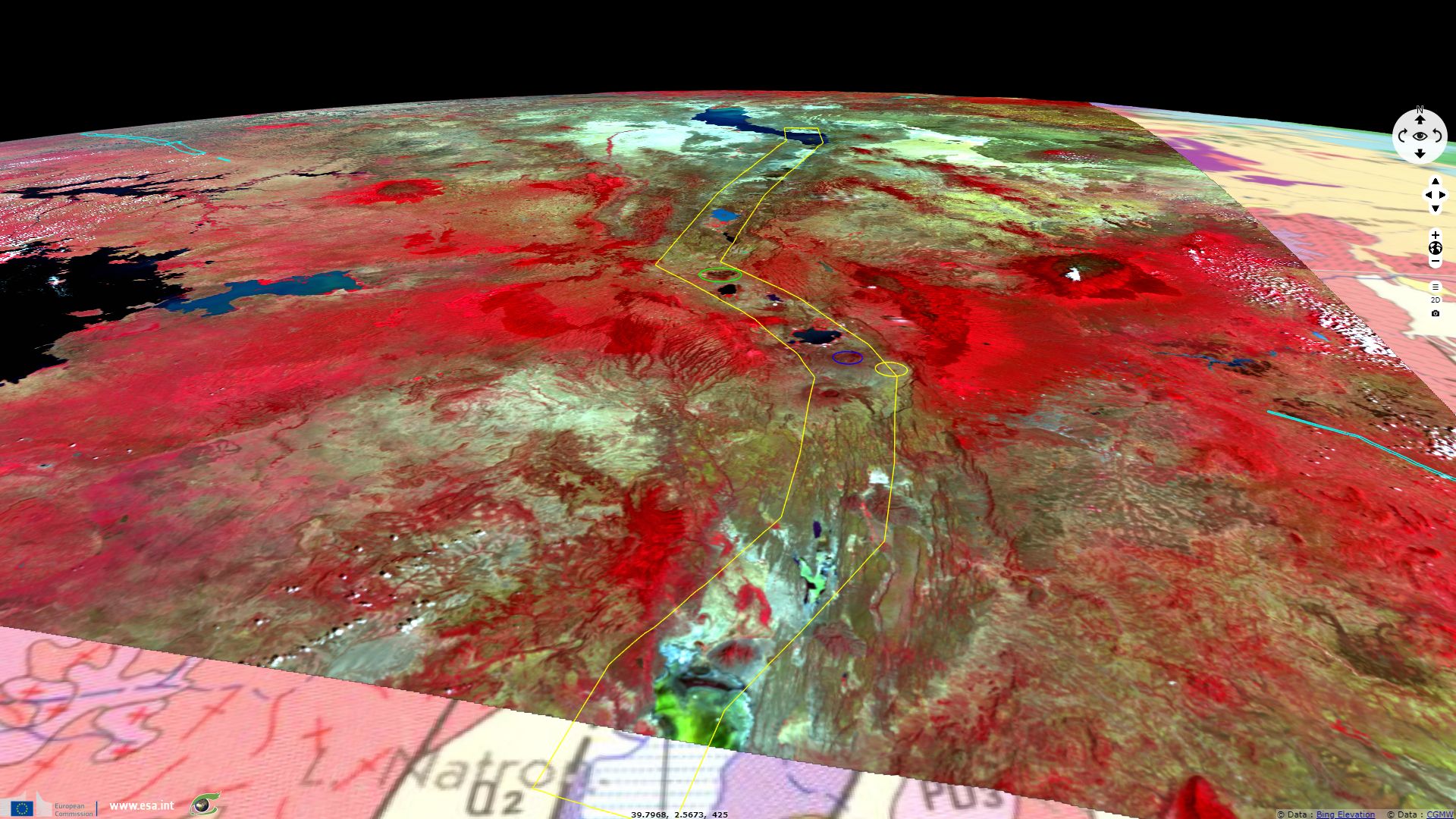
He comments: "The Kenya Rift (yellow double line) is a S-shaped part of the East African Rift System, comprising from north to south: - a N-striking segment (including Lake Baringo in blue colour) from S-end of Lake Turkana to Menengaj caldera (green circle); - a NW-striking segment at the intersection with a large Proterozoic fault zone, the Aswa Shear Zone (cyan lines); - a N-striking segment from Longonot volcano (blue circle) to Lake Natron (green colour).
Rift shoulders are high (more than 3,000 m) along the NW-striking segment and belong to a large dome mostly covered with forest, of which belts of vegetation are distributed over different altitudes. The rift floor, mostly savanna or bush, comprises several lakes. Lake Nakuru south of the Menengaj caldera is situated inside a distinct short graben. Between lakes Elmenteita and Naivasha there is a volcanic area called ‘the Elmenteita Badlands’ comprising the ‘split crater’ (white point) - a small faulted Quaternary volcano. Lake Nyanza (Victoria) is far (100 km) west from the East African Rift and does not belong to it. A 150 km long WSW-striking Nyasa graben is connected to the Kenya rift.
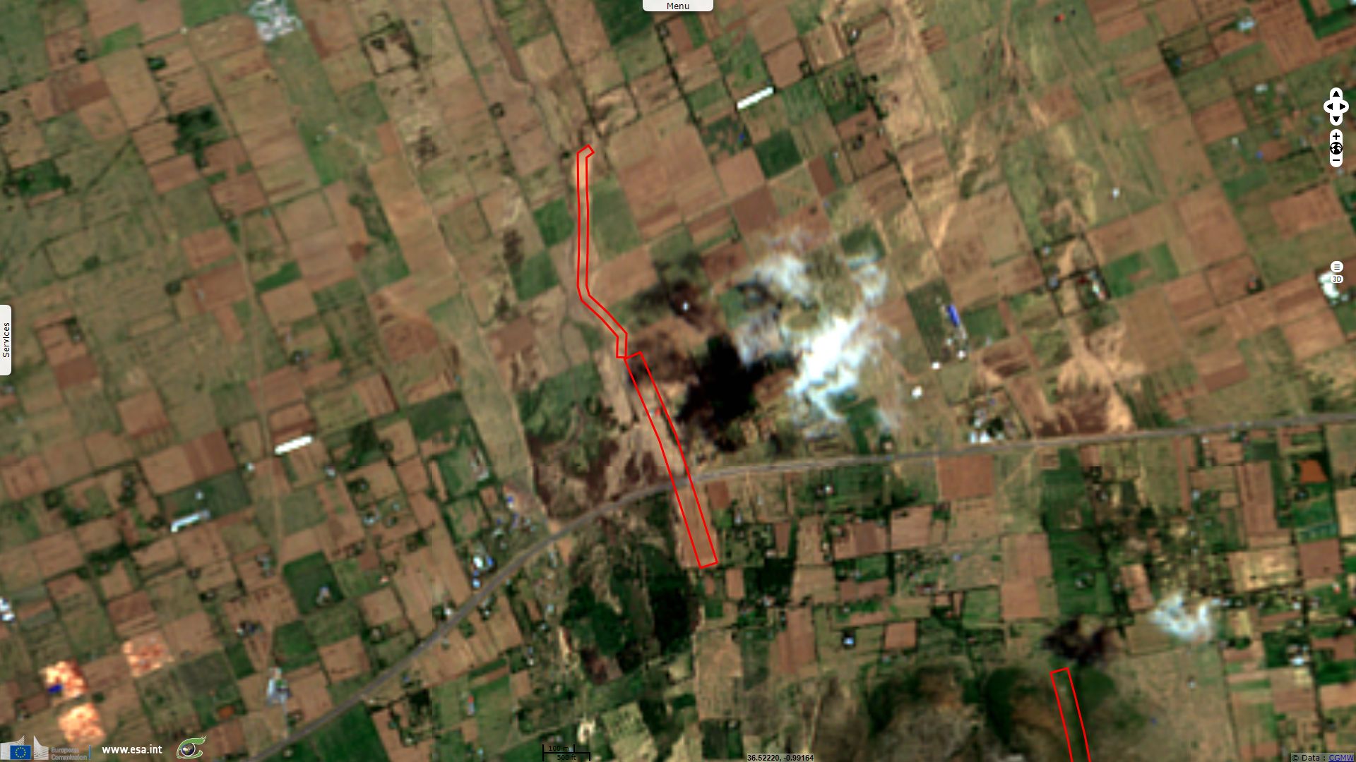
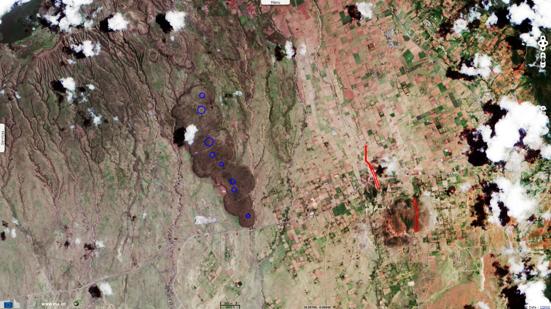
A spectacular fissure occurring on March 19, 2018 across a main road (inside yellow circle in fig. 1) near Longonot volcano was the subject of several comments by scientists and reporters (see below).”
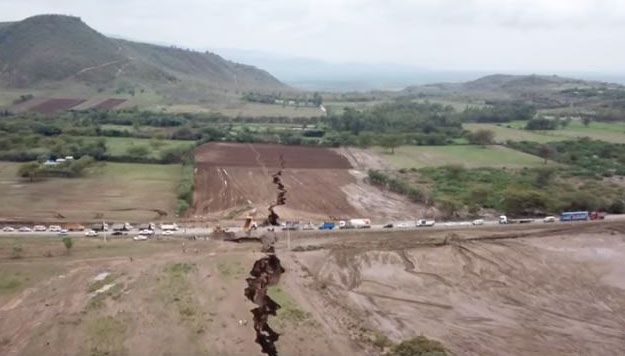
Spectacular ‘fissure’ that formed on March 19, 2018 (location in fig. 1) - source : Robert Gichira for Kenyan Nation TV.

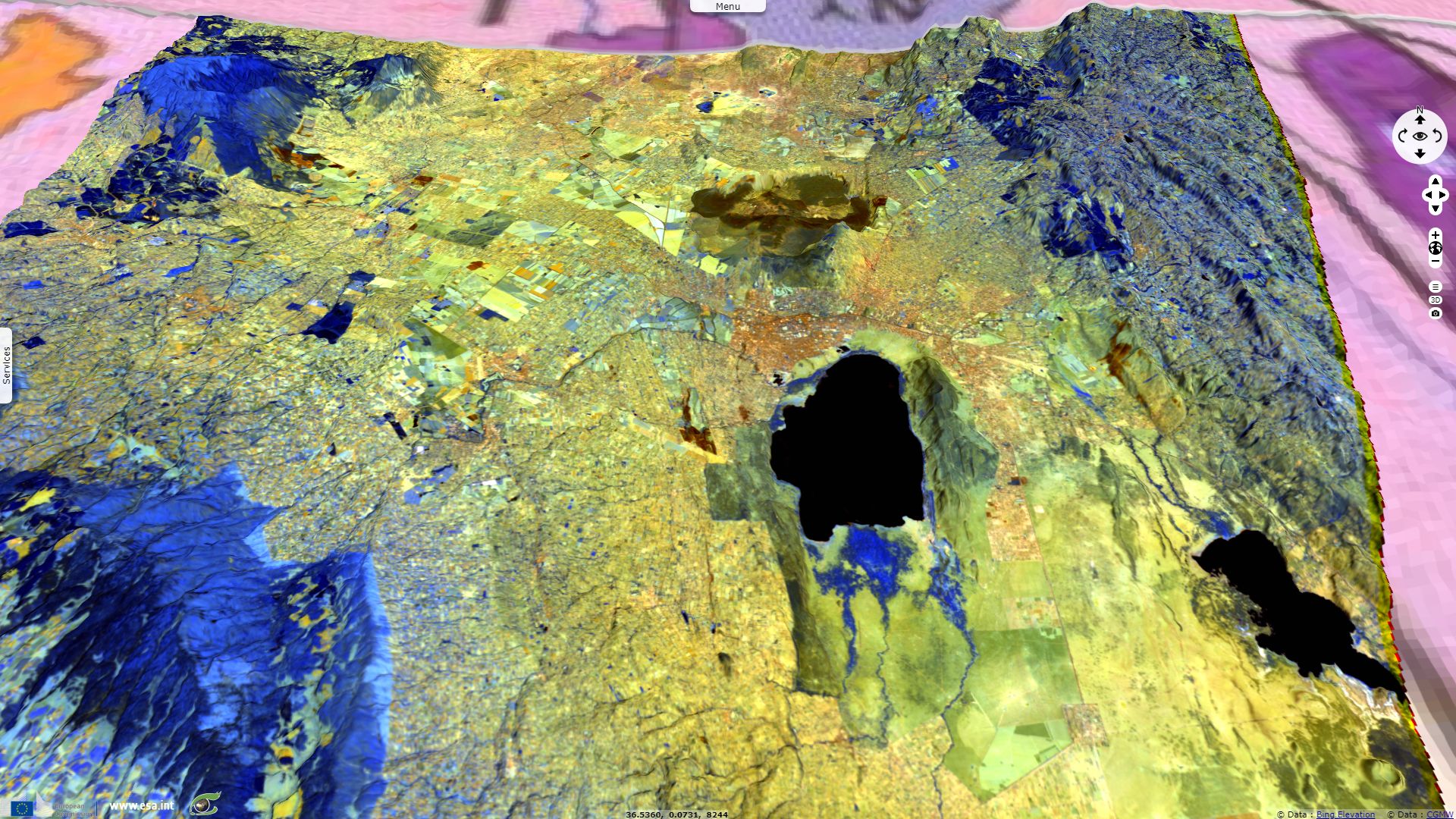
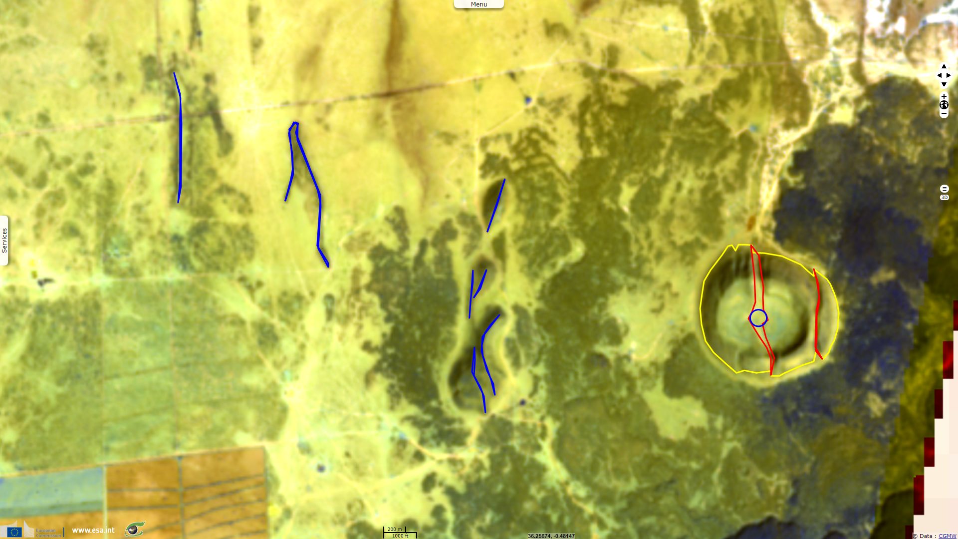
Comments from Pr. Jean Chorowicz: "Menengaj caldera is a volcano that entirely collapsed and former base is now in relief all round. The caldera scarp is poorly eroded, forming a large irregular circle of arched segments that are compatible with vertical fault motion. The volcano is the locus of the Menengaj Geothermal Project for electric supply.
Lava flows occupy the caldera floor with colour aspects that depend on their rock nature – most are black bare basalts - and on their age according to the state of the vegetation. Most lavas show at their surface flow patterns that look like waves, from which the sense of lava progression can be deduced. Many of the recent (black) lava flows are issued from an arc-shaped open fracture across the caldera from west to east (green lines). The flows issued from both tips have clear wave patterns. The eastern end of the fissure connects with the termination of a N-striking normal fault (red line), west compartment down, tangent to the eastern caldera rim where it ends. This tectonic pattern can be explained by the termination of a normal fault having a dextral oblique-slip throw component, opening a tail-crack (the green line) giving way up to magma and in which the offset vanishes. This model implies that extension in the area should be oriented NW-SE.
There is also a diametral N-S inferred open fracture (yellow lines and circles) giving: 1) a large fan-shaped lava flow in the northern part of the caldera: 2) a small active cone of projections in the center; 3) a N-S line of adjacent vents in the south. More ancient lavas with flow patterns forming the floor of the caldera were also issued from this N-S open fracture or from the arched one.”
Comments from Pr. Jean Chorowicz: "South of the Menengaj caldera, Lake Nakuru lies inside a short N-striking graben, a collapsed tectonic block bordered by extensional faults which scarps face each other. Most normal fault scarps in the region, including the eastern shore of Lake Nakuru, look west and tilted blocks dip east: in cross-section the East African Rift is asymmetric.”
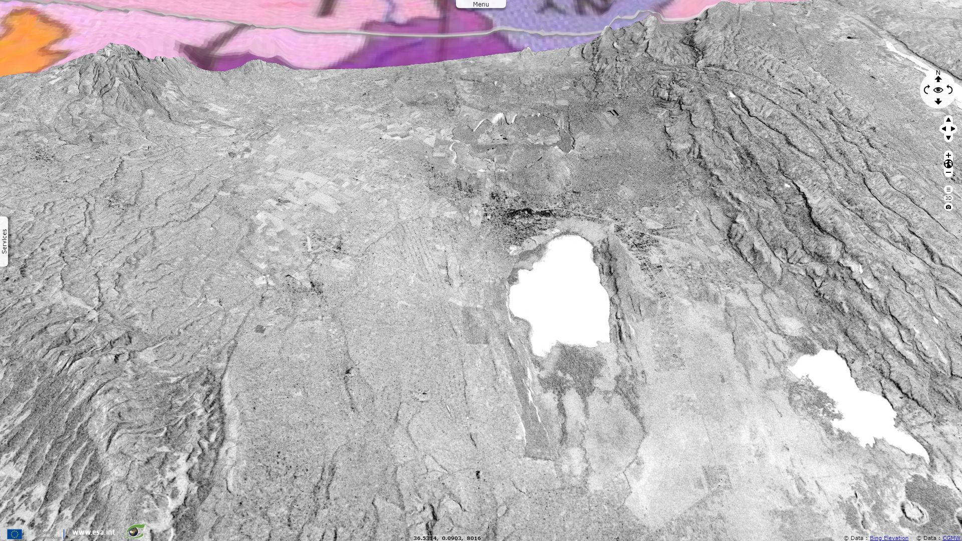
Comments from Pr. Jean Chorowicz: "Along the western lake shore however there is an east-looking fault scarp (in white, no adjacent black line according to CSAR illumination and negative view). Higher in the shoulder there are elongate volcanic dykes (white E-looking and black W-looking slopes). These wall-shaped volcanic venues (volcanic ridges) of viscous lava have reached the surface using N-striking open tension fractures.”
Comments from Pr. Jean Chorowicz: "Several fractures occur in the Elmenteita Badlands. The split crater is a recent, non-eroded circular volcano, with a well exposed crater and a plug at the center. A few faults affect the volcano, but nearby they are hidden by lava flows. Its N-S diameter is an open fault that includes the plug. The fault is right-lateral strike-slip for the eastern half of the split volcano is dextrally offset against the western half. The eastern slope is cut by a distinct W-dipping normal fault. The history of this volcano can be written as follows: 1) formation of a N-striking open fault; 2) volcanic activity from the fault, forming the cone, crater and plug; 3) continuing fracture opening and right-lateral strike-slip movement; 4) lava flows from other volcanoes covering the faults.
Immediately west of the split volcano, there is a small volcanic dome, to which a short and a longer N-striking volcanic ridges are connected (two blue lines). This pattern prolongs northward with other N-striking volcanic ridges. Other thin volcanic lines and a thin volcanic ridge appear more to the NW.
In the Kenyan rift it is then clear that N-striking sub-vertical open tension joints and faults served as ways up to volcanic products while they opened.”
Comments from Pr. Jean Chorowicz: "
The N-striking ‘fissure’ that appeared near Suswa on March 19, 2018 just after heavy rains can be sensed in the image-after (March 25, 2018) by changes in aspects of the concerned fields compared to the image-before (Fig. 7, February 28, 2018). There are no vertical nor horizontal displacements parallel to the ‘fissure’ (see image from Robert Gichira for Kenyan Nation TV).”
Comments from Pr. Jean Chorowicz: "The heavy rains before the event can be sensed for wet surfaces render the February 28, 2018 image particularly dark. They may have modified rupture parameters inside rocks in depth.”
Comments from Pr. Jean Chorowicz: "The main road is tangent to dark lava flows located 6 km west of the intersection with the ‘fissure’. This homogeneous elongate group of lavas shows ancient wave flow patterns on their surface permitting to locate the vents where they issued from. These vents are aligned in the NNW-SSE direction and are close to each other. They belong to a unique open fracture that served for the magma to reach the surface.
A heart-shaped (in vertical view) low dome volcano located 500 m south of the main road has its eastern slope cut by an ancient N-striking fracture. The colour composite red linear surface at western slope and a white one 2 km SE off the volcano are quarries.
The conclusion is that the ‘fissure’ is a tension joint not an open fault nor an erosional gully. This is not a fault for there are no vertical nor horizontal offsets of the two sides locally near the 'fissure'. Tension joints are common features in the tensional environment of the Kenya Rift and they also may give way up to magmas formed in depth by adiabatic decompression. The new tension joint lays close to the eastern boundary of the rift in a volcanic area.”
The views expressed herein can in no way be taken to reflect the official opinion of the European Space Agency or the European Union.
Contains modified Copernicus Sentinel data 2026, processed by VisioTerra.
Contains modified Copernicus Sentinel data 2026, processed by VisioTerra.
| More on European Commission space: |  |
 |
 |
||||
| More on ESA: | |
|
|
S-1 website | S-2 website | S-3 website | |
| More on Copernicus program: | |
|
|
Scihub portal | Cophub portal | Inthub portal | Colhub portal |
| More on VisioTerra: | |
|
|
Sentinel Vision Portal | Envisat+ERS portal | Swarm+GOCE portal | CryoSat portal |