East African Rift across Aswa Shear Zone
Sentinel-3 OLCI FR acquired on 07 January 2017 from 07:29:49 to 07:35:49 UTC
Sentinel-3 OLCI FR acquired on 27 January 2017 at 07:11:04 UTC
...
Sentinel-1 CSAR IW acquired on 16 March 2017 from 03:18:45 to 03:19:10 UTC
Sentinel-2 MSI acquired on 31 October 2017 at 07:40:29 UTC
Sentinel-3 OLCI FR acquired on 27 January 2017 at 07:11:04 UTC
...
Sentinel-1 CSAR IW acquired on 16 March 2017 from 03:18:45 to 03:19:10 UTC
Sentinel-2 MSI acquired on 31 October 2017 at 07:40:29 UTC
Keyword(s): land, geology, geohazard, continental rift, belt, drag fold, drag virgation, fault scarp, isocline fold, shear zone, strike-slip fault, transcurrent movement, Aswa Shear Zone, East African Rift, Kenya, Kilimanjaro, Lake Albert, late Proterozoic, Mount Elgon, Mount Kenya, Ngorongoro, Nyanza graben, Ol Donyo Sabuk volcano, Panafrican orogeny, Nile, Sudan, Yatta Plateau
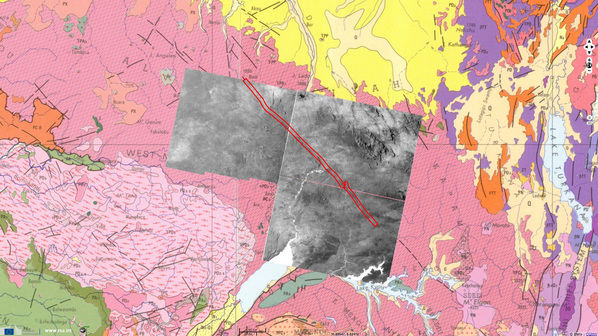
Pr. Jean Chorowicz, emeritus Professor at Sorbonne University (jean.chorowicz@upmc.fr) comments: "In Eastern Africa, the Aswa shear zone (ASZ) is a major late Proterozoic subvertical NW-trending structure affecting the whole lithosphere and which belongs to the collisional Panafrican belt system (550 Ma). It can be remotely sensed and mapped over a length of 1,500 km. It had major effects when cut by the Cenozoic propagation of the East African Rift system.
The ASZ shows up in images as a linear narrow low area. It is made of mylonitic rocks, mainly particular gneisses that are equivalent to a ductile shear zone more easily removed by weathering-erosion process than the other rocks outcropping on both sides.
Lake Albert and the river Nile express in white in the CSAR images (descending mode looking west, negative display). The Nile leaves the Albertine graben to the north then aims NE-ward into the smaller Rhino graben and then sharply turns left where it meets the ASZ. At the junction and elsewhere along the shear, the SW compartment shows tight folds formed during the Panafrican orogeny. The main N-striking structural lines progressively change in strike to the NW, shaping typical drag-folds with sub-vertical axes which indicate that relative motion along the shear zone during the Panafrican was sub-horizontal, i.e. strike-slip (transcurrent movement). These features attest to left-lateral motion. This means that looking at one compartment from the other one, it has moved to the left. Large Panafrican folds also can be observed in forest areas far from the shear zone. In the NE compartment similar drag features are apparent but structures here are quite different and give a more homogeneous landscape.
The ASZ can be observed along a great distance in the SE-trend after a relay zone, it then disappears in the forest but is drawn as inferred fault in the geological map. It is obvious that the northern segment of the Western Branch of the EARS represented by the Albertine-Rhino grabens sharply terminates against the ASZ."
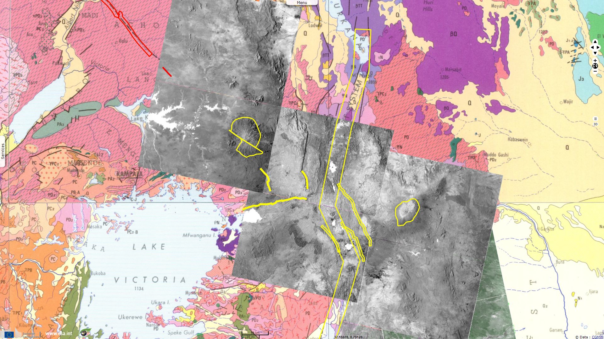
Comments from Pr. Jean Chorowicz: "Between volcanoes Elgon (4,321 m) and Kenya (5,194 m), the late Proterozoic rocks poorly outcrop for they are mostly covered by Neogene volcanic materials: the ASZ does not show up. However, NW-trending structures are existing in the East African Rift in the crossing region mainly in Kenya.
Mt Elgon is a large central volcano cut into two parts by a badly expressed NW-SE left-lateral strike-slip fault zone. The nearby Webuye scarp well expressed in the CSAR imagery is in line with the ASZ and is poorly eroded, which means this fault is relatively young. It can be regarded as brittle Neogene local reactivation of the late Proterozoic ductile ASZ.
The northern segment of Kenya Rift strikes N-S, then turns to NW-SE and again to N-S but most faults and tilted blocks remain in the N-S strike. Major complex rift borders such as south Kerio, Mau, Gilgil and Aberdere scarps are in the NW direction. NE-trending structures that are possibly inherited from more ancient structures also lay in the area: - the Nyanza asymmetric graben (major bordering fault on northern side) has a general ENE trend; - the Mt Kenya volcanic edifice has an elliptic shape with long axis trending NE."
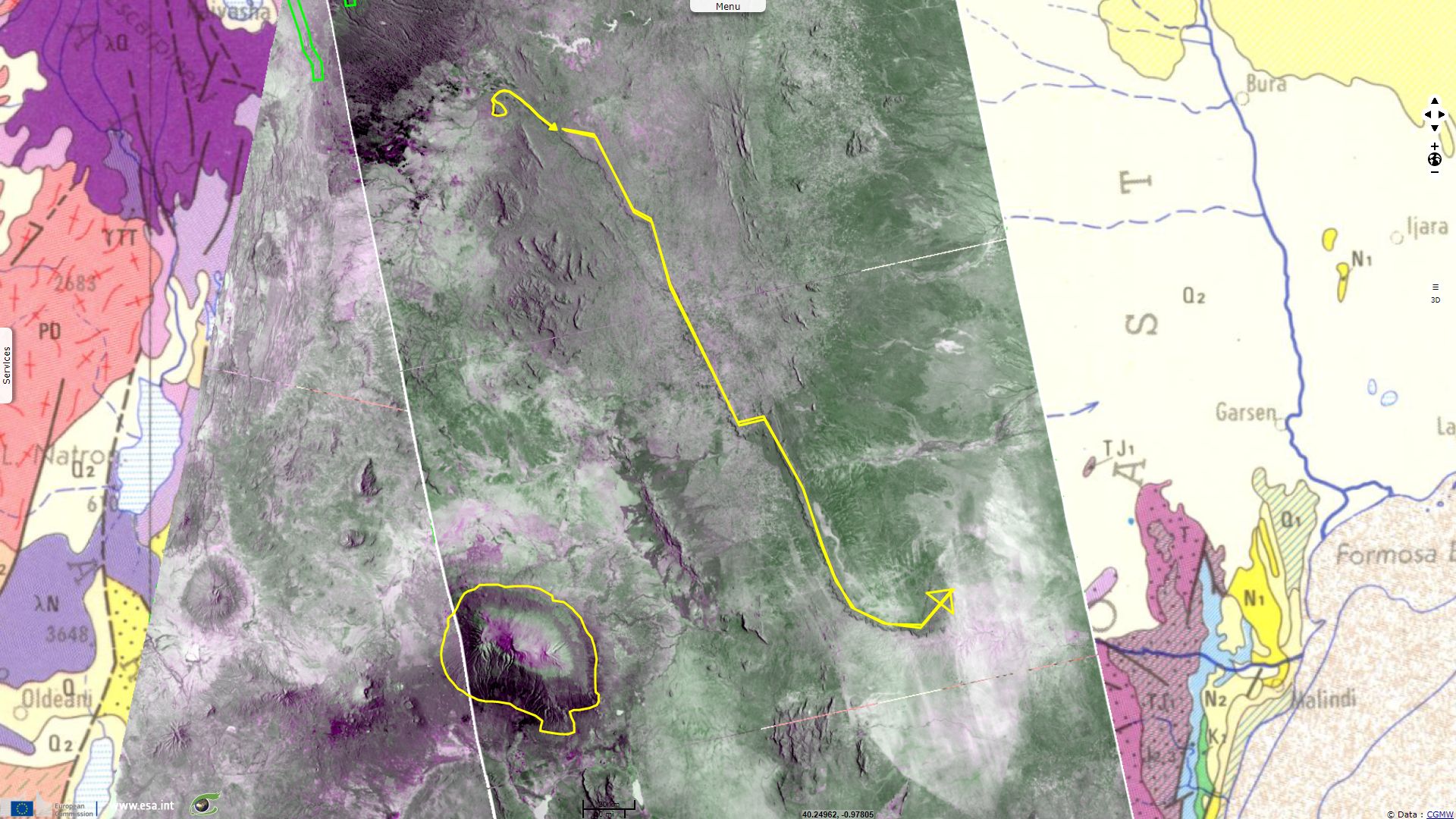
Comments from Pr. Jean Chorowicz: "The Yatta Plateau is an exceptionally long but narrow lava flow (330 km in length, a few km in width maximum) formed by a very fluid lava effusion that flowed along a paleo-valley, forming a NW-SE lineament in the landscape. Nearby, the Kilimanjaro volcano has a large central dome peak reaching 5,895 m in elevation. The base is elliptic-shaped with NW-trending longer axis."
Comments from Pr. Jean Chorowicz: "The imagery shows that the Yatta plateau flow originated from the Ol Donyo Sabuk dome volcano (2,150 m) south of Mt Kenya."
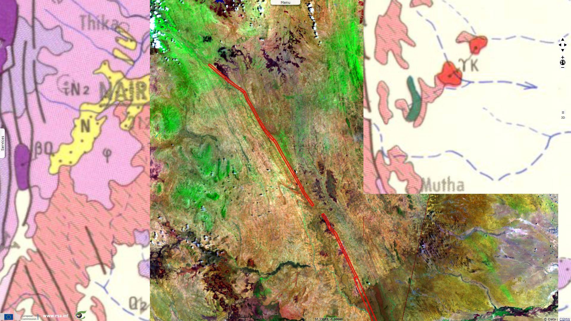
Comments from Pr. Jean Chorowicz: "At bottom of the Yatta plateau, late Proterozoic Panafrican structures form isocline folds with sub-vertical axes. This permits to locate the NW-striking shear zone between two regions: in the SW compartment, folds are obvious; in the NE compartment, structural lines of metamorphic units are more parallel to each other and form a large gentle drag virgation that characterizes left-lateral strike-slip paleo-movements. This NW-striking shear zone east of the Kenya rift is almost in line with the ASZ west of the rift and then represents also the ASZ. This southern segment of the ASZ can be precisely mapped where folds occur and completed by continuity parallelly to the late Proterozoic structural lines."
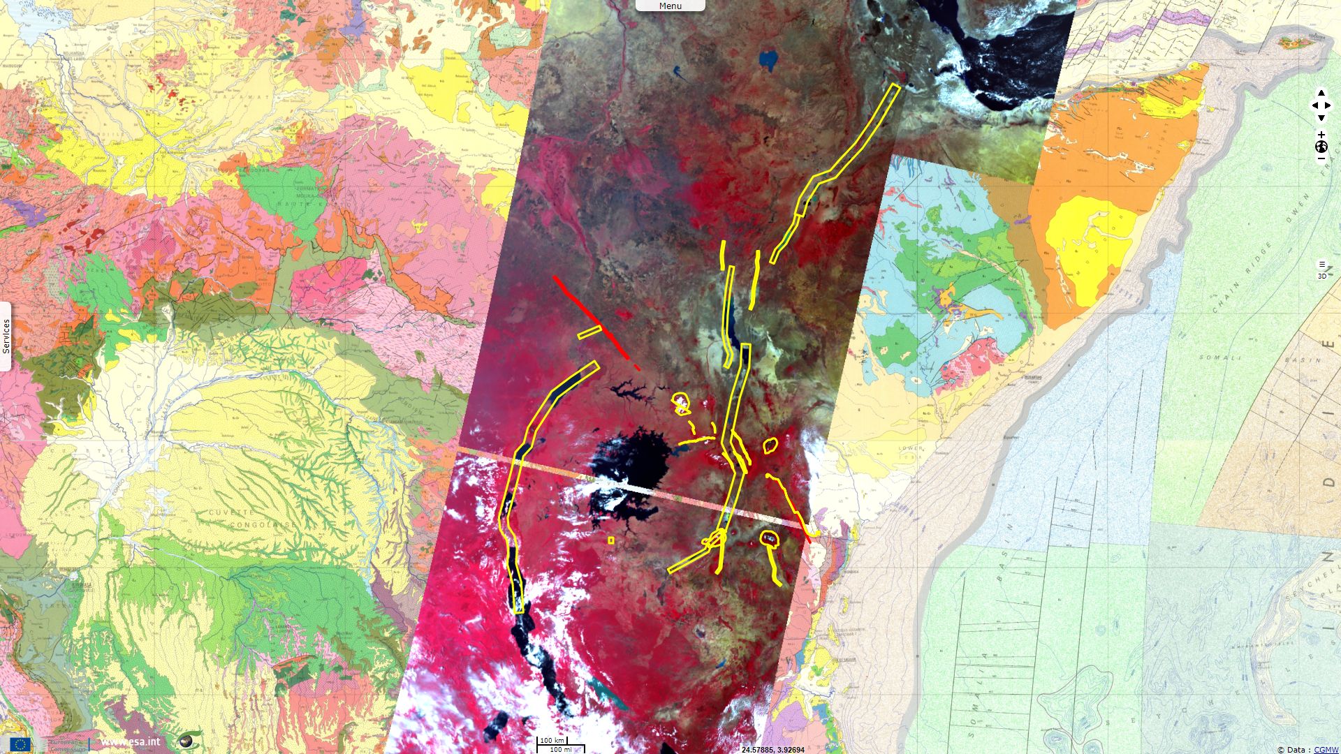
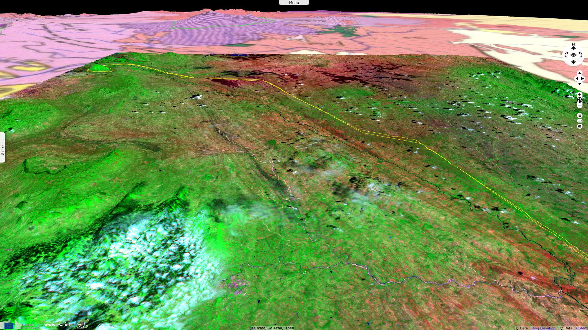
Comments from Pr. Jean Chorowicz: "The synoptic pattern of Eastern Africa provided by S3 imagery, Geological map (CGMW) and copy of interpretations of the preceding detailed views shows large features in the East African Rift System at intersection with the ASZ.
The late Proterozoic ASZ (in red) can be observed far in the NW and SE at both sides of the rift zone. It has major effects on the EARS. It marks the northern end of the Western branch. It has been tectonically reactivated at the northern end of the Albertine-Rhino grabens and more to the SE along the Elgon fault and Webuye scarp. The Eastern branch is deviated and finally ends south of the ASZ in the North Tanzanian craton. Major volcanoes lie in the intersecting area among which Elgon, Kenya, Kilimanjaro and Ngorongoro.
This lineament in old continental lithosphere can be considered during the East African Rift evolution as analog to a transform fault zone but more complex than those lying in oceanic lithosphere because of the heterogeneity of the continental basement. This intracontinental transform zone is strike-slip left-lateral.
The widespread volcanism in this region, by contrast with the lack of volcanism in the Western branch, is related to the Neogene northward movement of Africa over the Tana plume (see EVT-263 - Geology in the Ethiopian Plateau) and subsequent opportunities for Neogene magmas to reach the surface across a tectonically active area."
The views expressed herein can in no way be taken to reflect the official opinion of the European Space Agency or the European Union.
Contains modified Copernicus Sentinel data 2026, processed by VisioTerra.
Contains modified Copernicus Sentinel data 2026, processed by VisioTerra.
| More on European Commission space: |  |
 |
 |
||||
| More on ESA: | |
|
|
S-1 website | S-2 website | S-3 website | |
| More on Copernicus program: | |
|
|
Scihub portal | Cophub portal | Inthub portal | Colhub portal |
| More on VisioTerra: | |
|
|
Sentinel Vision Portal | Envisat+ERS portal | Swarm+GOCE portal | CryoSat portal |