Sedimentary evolution of the Little bay of Mont Saint Michel, France
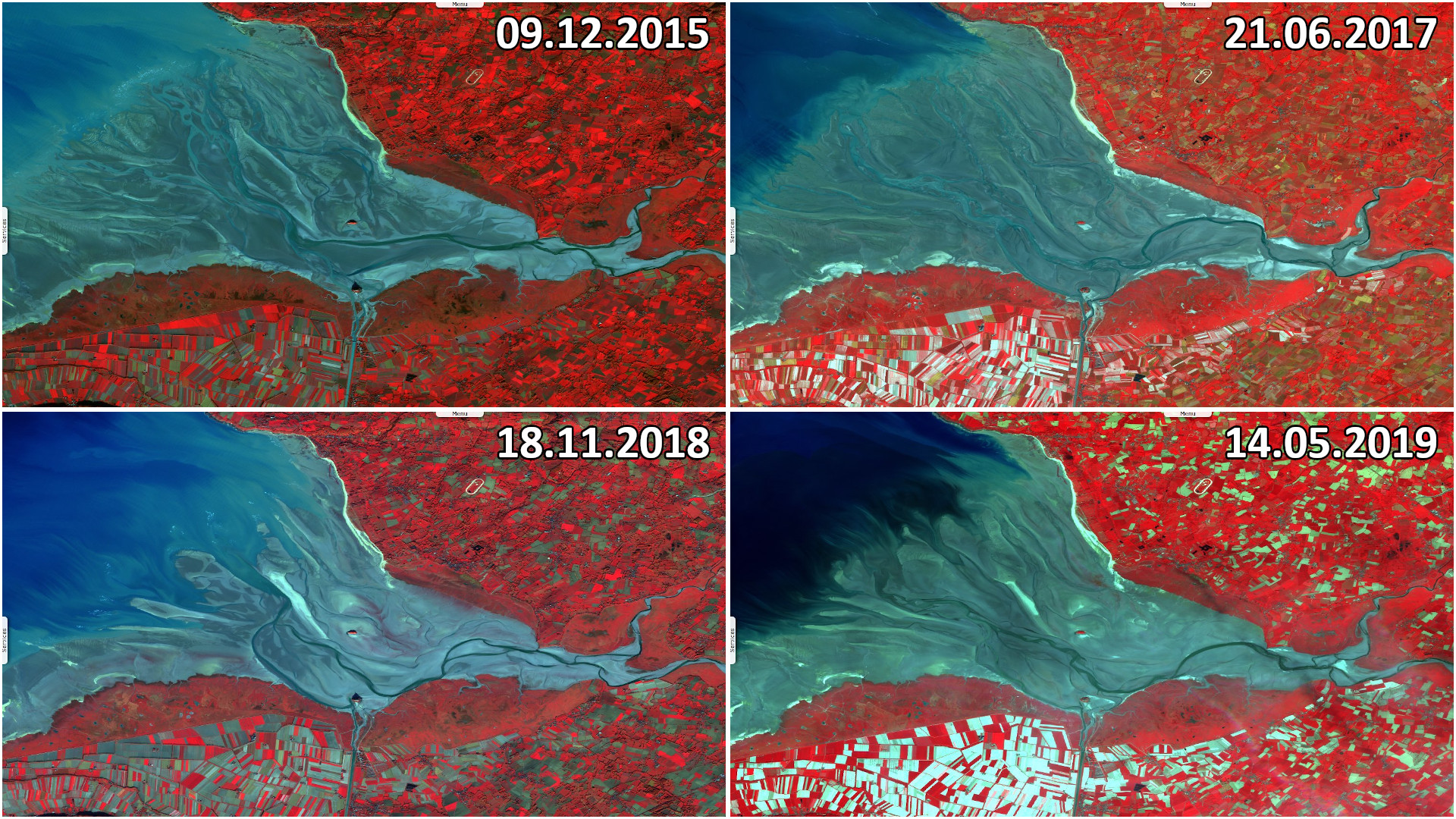
Sentinel-2 MSI acquired on 09 December 2015 at 11:14:42 UTC
...
Sentinel-2 MSI acquired on 21 June 2017 at 11:06:51 UTC
Sentinel-2 MSI acquired on 15 June 2022 at 11:06:31 UTC
Sentinel-2 MSI acquired on 01 April 2023 at 11:06:21 UTC
...
Sentinel-2 MSI acquired on 21 June 2017 at 11:06:51 UTC
Sentinel-2 MSI acquired on 15 June 2022 at 11:06:31 UTC
Sentinel-2 MSI acquired on 01 April 2023 at 11:06:21 UTC
Keyword(s): Coastal, hydrology, UNESCO world heritage, Ramsar, tidal flats, France
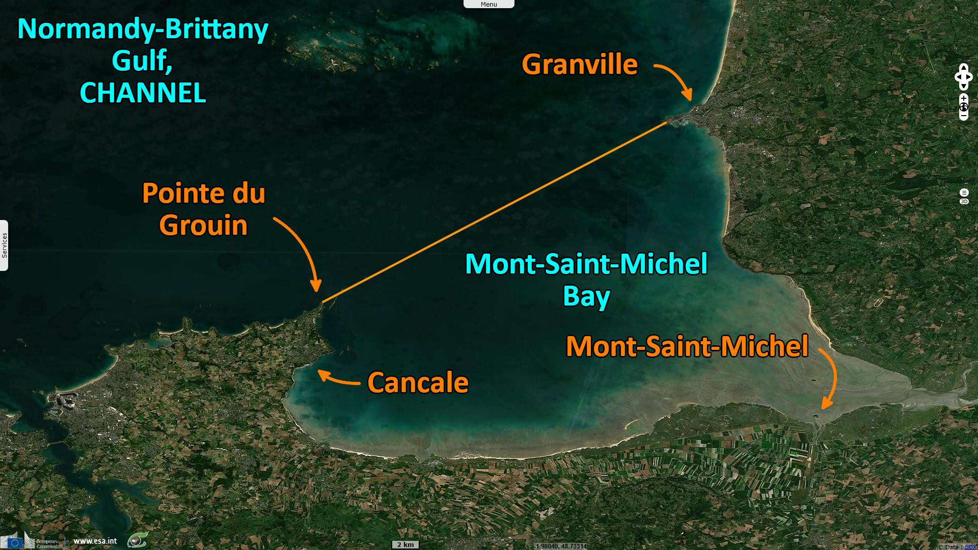
Mont-Saint-Michel Bay was listed as a UNESCO world heritage site in 1979 for its aesthetic quality and its importance to the Christian tradition. Some of the biggest tides in Europe occur in Mont-Saint-Michel Bay: with an average 10 metres amplitude, they reach 12 metres in average and up to 16 metres during the highest tides. Polders have been developed in Mont-Saint-Michel Bay from the 8th century or earlier than that.
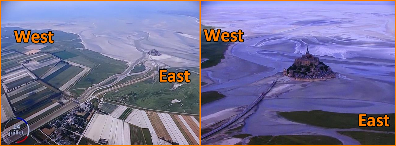
Mont-Saint-Michel lies on an island located approximately one kilometre off France's north-western coast, at the mouth of the Couesnon River near Avranches and is 7 hectares in area. The commune's position — on a tidal island just a few hundred metres from land—made it accessible at low tide to the many pilgrims to its abbey, and defensible as the incoming tide stranded, drove off, or drowned would-be assailants. The construction of the first monastic establishment started in the 8th century. The island now encompasses a gothic-style Benedictine abbey dedicated to the archangel St Michael and the village that grew up in the shadow of its great walls.
A conference on "the evolution of sedimentation in the Petite Baie du Mont Saint Michel" was held on 8 May 2023 in Carolles. Patrick Bouland, Patrick Dacheux and Patrick Letouzey, members of the Association de Défense de la Vallée du Lude (ADVL), presented the results of their study:
Covering an area of around 500 km², at the bottom of the Normandy-Breton gulf in the Channel Sea, the 43 km² of the Bay of Mont Saint Michel is battered twice a day by some of the most powerful tidal ranges in Europe, and the rivers move in and out of the bay periodically as a function of the tides and storms. Like all bays, it is constantly being filled in naturally, but over the last two centuries it has been subjected to the encroachment of man, who has reclaimed the coastline. Since 2009, a hydrosedimentary management project around the rock of Mont Saint Michel, an emblematic monument, has made a major contribution to accelerating the transfer of sediments.
Over a century of man-caused clogging, sand has accumulated at the bottom of the bay and the schorres have progressed. Numerous impact studies have highlighted the same scenario, with the risk of the Mont losing its insularity in the near future.
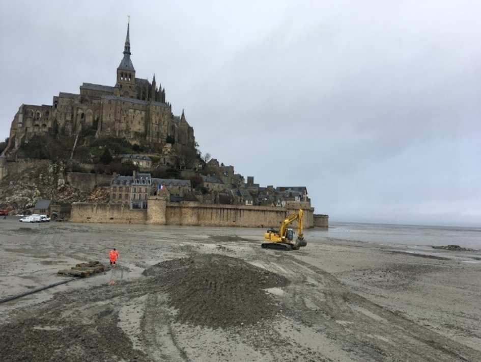
To counter the impact of this sedimentary progression, a major and innovative environmental engineering project is planned. This project, known as the "sand clearance of Mont Saint- Michel" was initiated in 1995 and the technical studies lasted until 2005. They showed that it was technically and financially impossible to bring back the sea at every tide period. A new project was proposed, which should enable the Rock to be surrounded by the tides twice a month. The driving force behind this operation will be the river Couesnon, which will be channelled and divided into two arms, one to the west and the other to the east, surrounding the Mount.
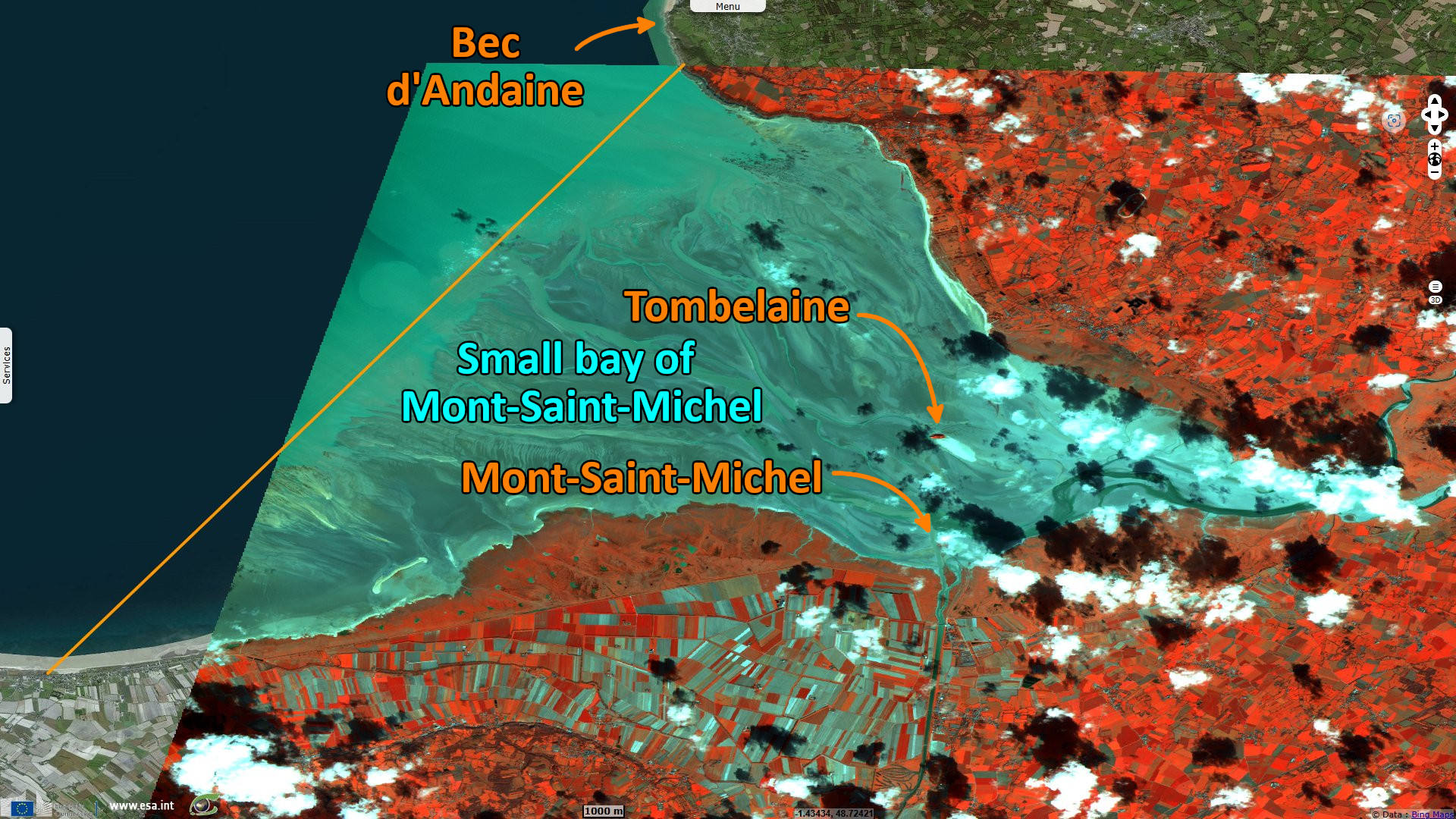
This image of Mont St. Michel, France, was acquired by ESA’s Proba satellite with its Compact High Resolution Imaging Spectrometer (CHRIS).
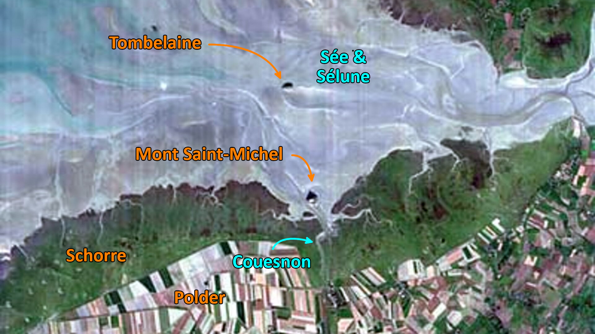
We can see the progression of the schorres or salt meadows surrounding Mont Saint-Michel to the west and east of the Rock. The rivers Sée and Sélune flow north of the Tombelaine Rock into the Petite Baie. From 2009 onwards, with the commissioning of a new dam on the Couesnon, the sluice gates will operate to flush sediments from the bay out to sea.
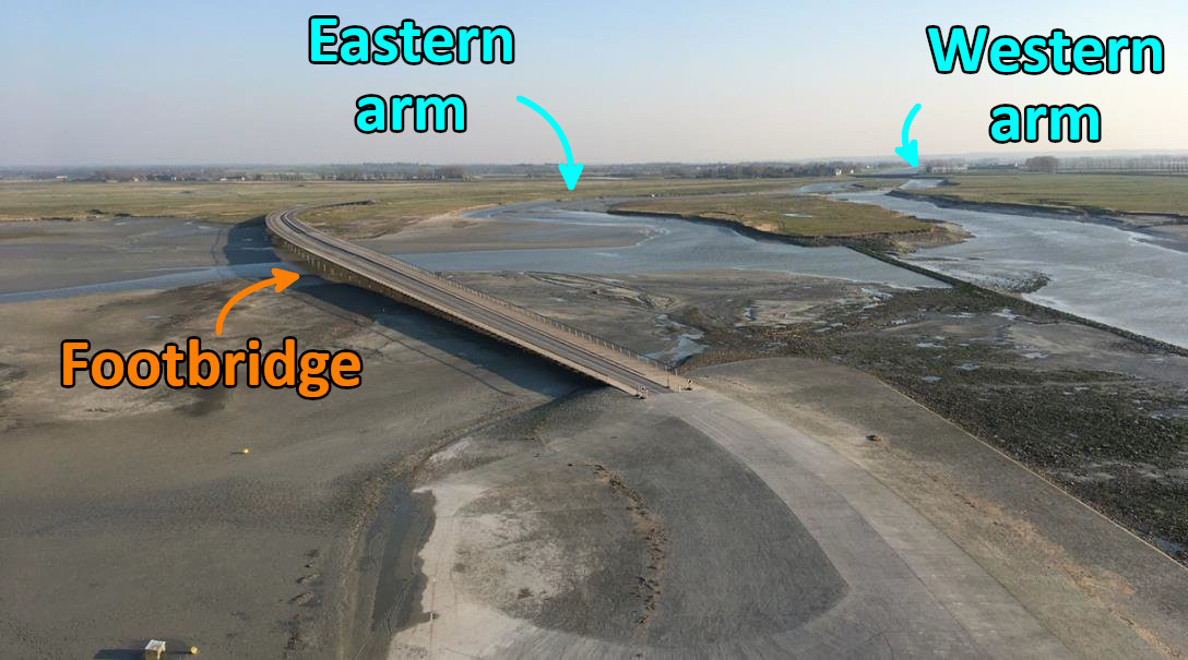
The Restoration of the Maritime Character (RCM) involves a new dam, a footbridge, two arms of the Couesnon and groynes to push sediment away from the Mont: In 2012, following the destruction of the dyke, a footbridge was built between the rock and the mainland, allowing the water to circulate around the Mont. With the operation of the second arm to the east of the Couesnon, the water circulates around the Mont, which is surrounded by the waters of the spring tides twice a month.
The sandbanks around the Mont were eroded by the flushing. The project was considered a success. But then came the problem of what would happen to the sediments that were dispersed and redeposited in the Bay. To measure the evolution of sedimentation in the Bay, VisioTerra presents a chronology based on Sentinel 2 A and 2 B satellite images between 2015 and 2022, selected twice a year, recorded at low tide, one at the beginning of the year and the other in the third quarter. In particular, erosion and sediment accretion in the vast transit of deposits from west to east.
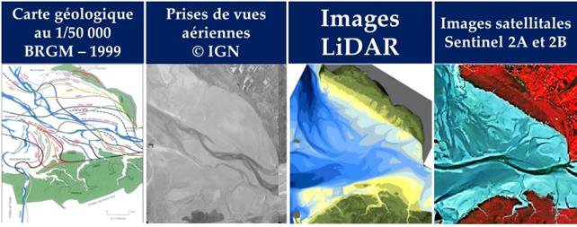
Sources of data used for this study include:
- Photographs taken by the authors of the study,
- BRGM maps, French Geological Survey and France's public reference institution in Earth Science applications for the management of surface and subsurface resources and risks,
- IGN aerial images, French National Institute of Geographic and Forest Information,
- LiDAR surveys acquired by the RCM between 2009 and 2020,
- Sentinel-2 images acquired between 2015 and 2023.
For 'pure' water, for example, reflectance is high in the blue, decreasing rapidly to become negligible in the near or mid infrared; alluvial deposits increase the reflectance of water in the green and red; bare soil is often fairly low in the blue, higher in the red and mid infrared; vegetated soil is low in the blue and red, but high in the green and mid infrared, and very high in the near infrared.
Here we use the blue channel for blue, the green channel for red and the red channel for near infrared. Vegetated areas are in red, mudflats, the foreshore and the tidal zone emerged at low tide are in light cyan, open water is similar but with less red, and channels are in dark cyan. In this way, observation can be carried out repeatedly, with a wide range of choices, each time showing objects in different wavelengths, which allows better definition and discrimination.
The Petite Baie is a narrow maritime area subject to powerful tides between two continental areas (Brittany to the west and Normandy to the east). The marine sediments form a vast deltaic cone. These images show the immensity of the areas uncovered at low tide (the "grèves"), criss-crossed by river channels separated by banks of sediment.
The Sée-Sélune couple has shifted from north to south, passing to the south of Tombelaine and, in correlation, developing deposits to the north of Tombelaine as far as the coast. The release of water at the bottom of the Bay should have surrounded the Mont, but the western arm of the Couesnon runs along the west coast (of Brittany), eroding it. The eastern branch, which is weaker, flows along the east coast (Normandy).
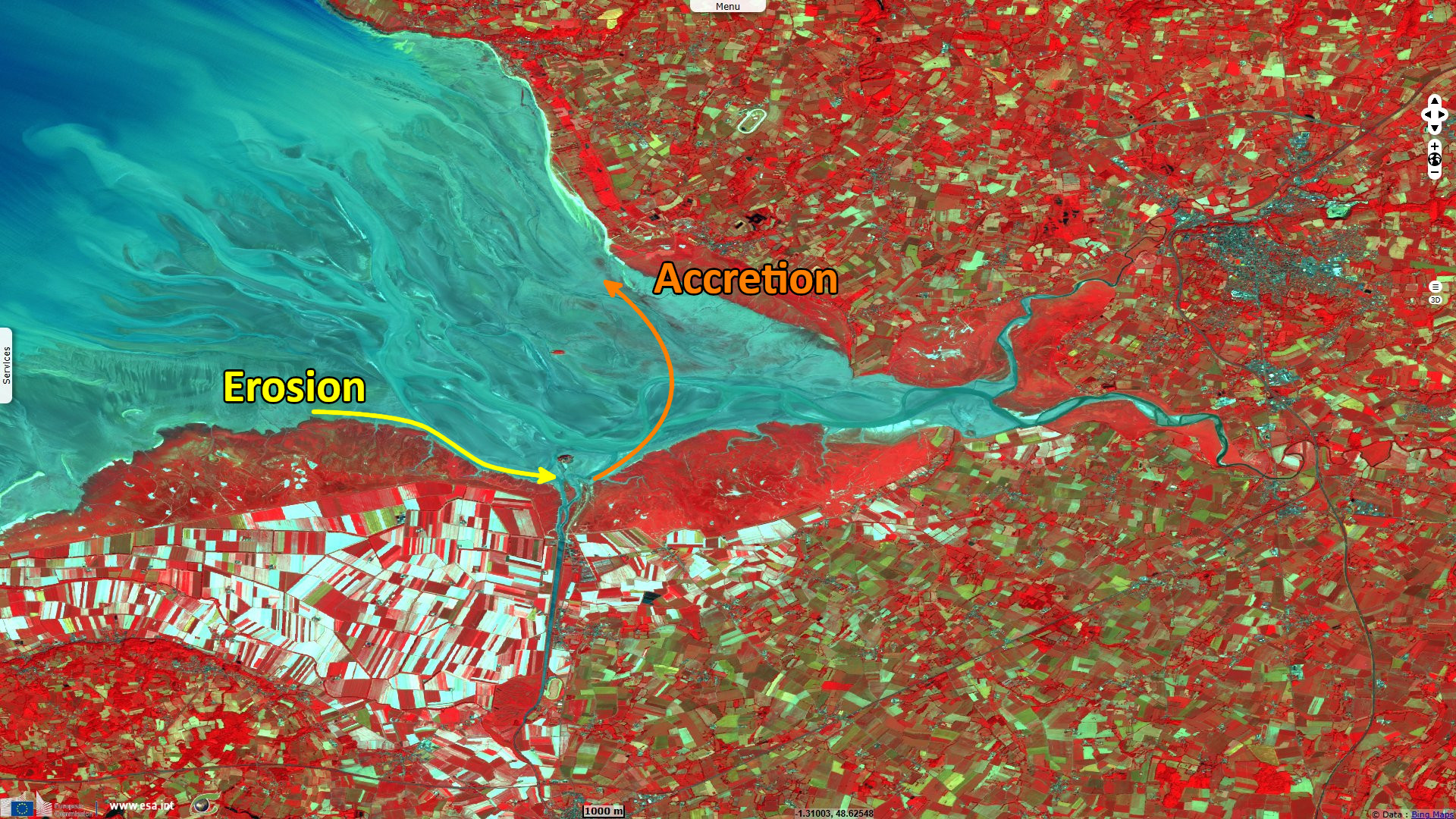
On the one hand, we can observe the erosion of the grasslands on the Breton side as a result of the displacement of the west channel of the Couesnon. These sediments are transported to the south of the Mont.
On the other hand, an accretion phenomenon is taking place, with the transit and deposition of these sediments in the eastern part of the Petite Baie, which is becoming fatter as water is released twice daily from the Couesnon dam.
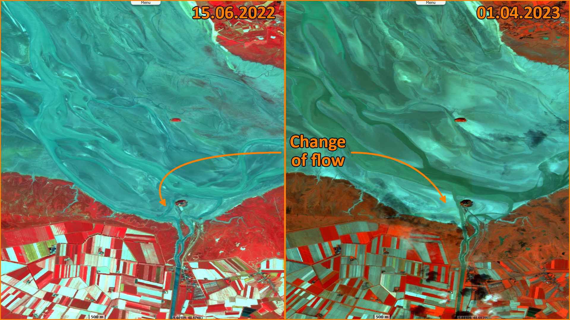
A weakened underwater dune which forced the western arm of the Couesnon to follow the south coast, eroding it (seen on Sentinel 2 from 2015 to 2022). In April 2023, following a climatic event, the western arm broke through and flows due north towards the Sée Sélune along the western flank of the Mont. The eastern arm curves sharply eastwards along the coast, blocked by the marine dune that has developed at the eastern foot of the Mont. To remedy this, a channel has been dug, with no real result to date.
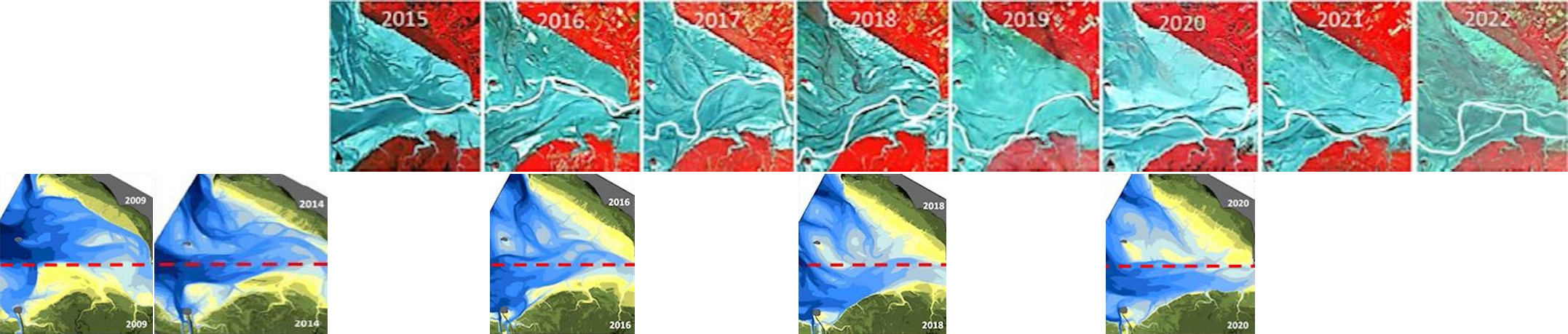
The article examines the link between the management of water releases from the Couesnon dam and sediment dynamics in the small bay of Mont Saint-Michel. Sentinel-2A and -2B data and their quantitative analysis (lidar data) show that topography, altimetry and hydrography have changed overall, with a reversal of topography since 2009 affecting the whole of the small bay.
The direction of the progression of sedimentary deposits and the movement of the Sée-Sélune remains oriented North --> South. However,
- before 2009, it was the south that was being deposited and the north that was being eroded,
- after 2012 it is the North that is being sedimented and the South that is eroding.
On the eastern flank at the foot of the Mont Saint-Michel, the current development of the sandy bank is clearly visible.
Since 2015, the program of restoration of the maritime character (RCM) of the Mont is effective with the construction of the footbridge and the dam on the Couesnon, which should push the sediment out to sea, through the flushing effects of two arms of the river, east and west. Very quickly, the east branch became ineffective and the members of the association argue that 10 years of flushing have not had the desired result. Instead of surrounding the Mont, the two branches have tended to move away from it, and there is now a wide sandbank at the foot of the Mont. The rivers Sée and Sélune wander off and return to settle at the northern foot of the Mont, before joining the Couesnon.
In the small bay, the rivers do not wander at random. Their movements are conditioned by sedimentary evolution (and not vice versa). More precise satellite surveys show two sediment outlets at Saint-Jean-le-Thomas and Champeaux. The dynamics of sediment transport, which began in 2009 (volumes calculated from Lidar data), are constant. Deposits (new sandbanks) are almost 5% equivalent to the deficit of sand from digging, so with very little input from Grande Baie. In detail, it's a mosaic of different situations within the small bay as observed chronologically on satellite images, the trend of which does not show in the medium term a return to the state of affairs prior to 2009.
The RCM (restoration of the maritime character) operation, with the release of water into the 2 arms of the Couesnon to the east and west, has profoundly altered this evolution.
The views expressed herein can in no way be taken to reflect the official opinion of the European Space Agency or the European Union.
Contains modified Copernicus Sentinel data 2026, processed by VisioTerra.
Contains modified Copernicus Sentinel data 2026, processed by VisioTerra.
| More on European Commission space: |  |
 |
 |
||||
| More on ESA: | |
|
|
S-1 website | S-2 website | S-3 website | |
| More on Copernicus program: | |
|
|
Scihub portal | Cophub portal | Inthub portal | Colhub portal |
| More on VisioTerra: | |
|
|
Sentinel Vision Portal | Envisat+ERS portal | Swarm+GOCE portal | CryoSat portal |