Lake Baikal, largest source of liquid freshwater in the World, Russia
Sentinel-1 CSAR IW acquired on 16, 21 and 26 February 2021
Sentinel-1 CSAR IW acquired on 11, 13 and 18 December 2021
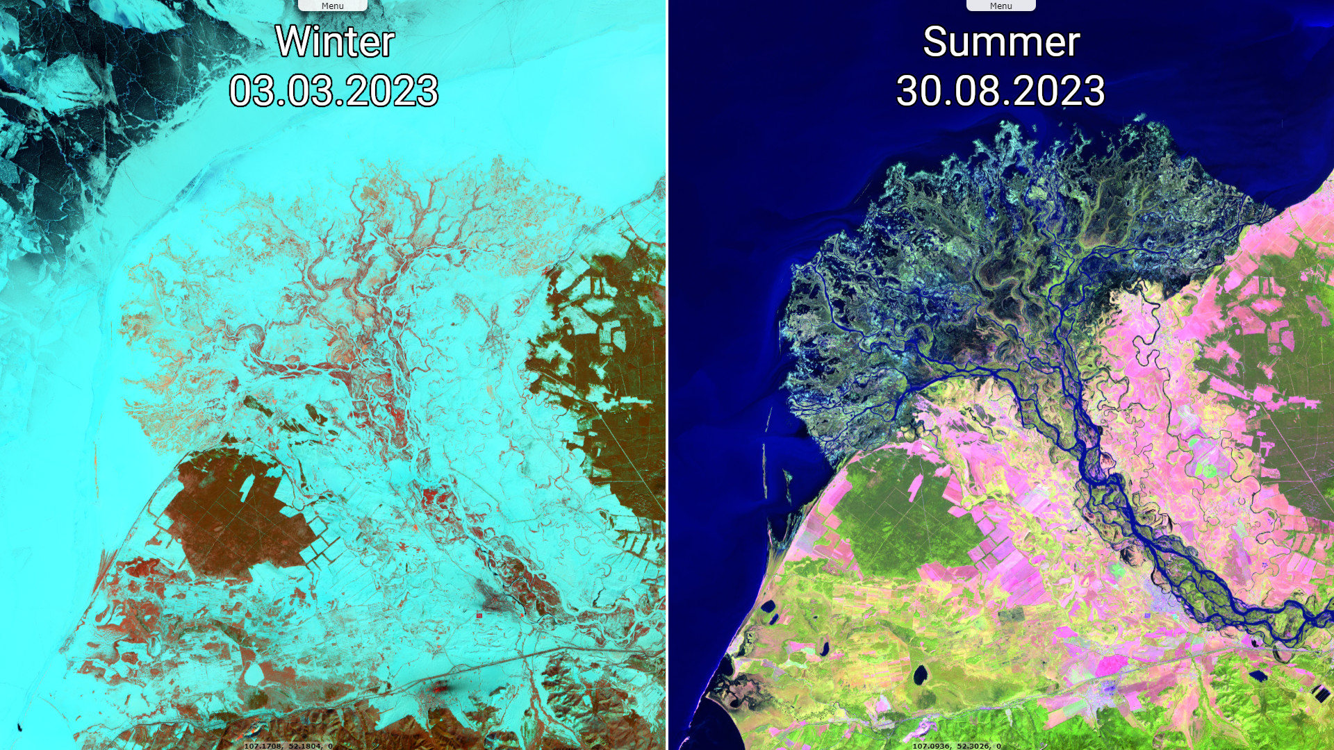
Sentinel-2 MSI acquired on 03 March 2023, 26 July 2023 and 30 August 2023
Sentinel-3 OLCI RR & FR acquired on 19 September 2023 from 03:02:07 to 03:05:07 UTC
Sentinel-1 CSAR IW acquired on 11, 13 and 18 December 2021
Sentinel-2 MSI acquired on 03 March 2023, 26 July 2023 and 30 August 2023
Sentinel-3 OLCI RR & FR acquired on 19 September 2023 from 03:02:07 to 03:05:07 UTC
Keyword(s): Hydrology, Geology, Lake, River, Rift, UNESCO World Heritage site, Selenga, Angara, Russia
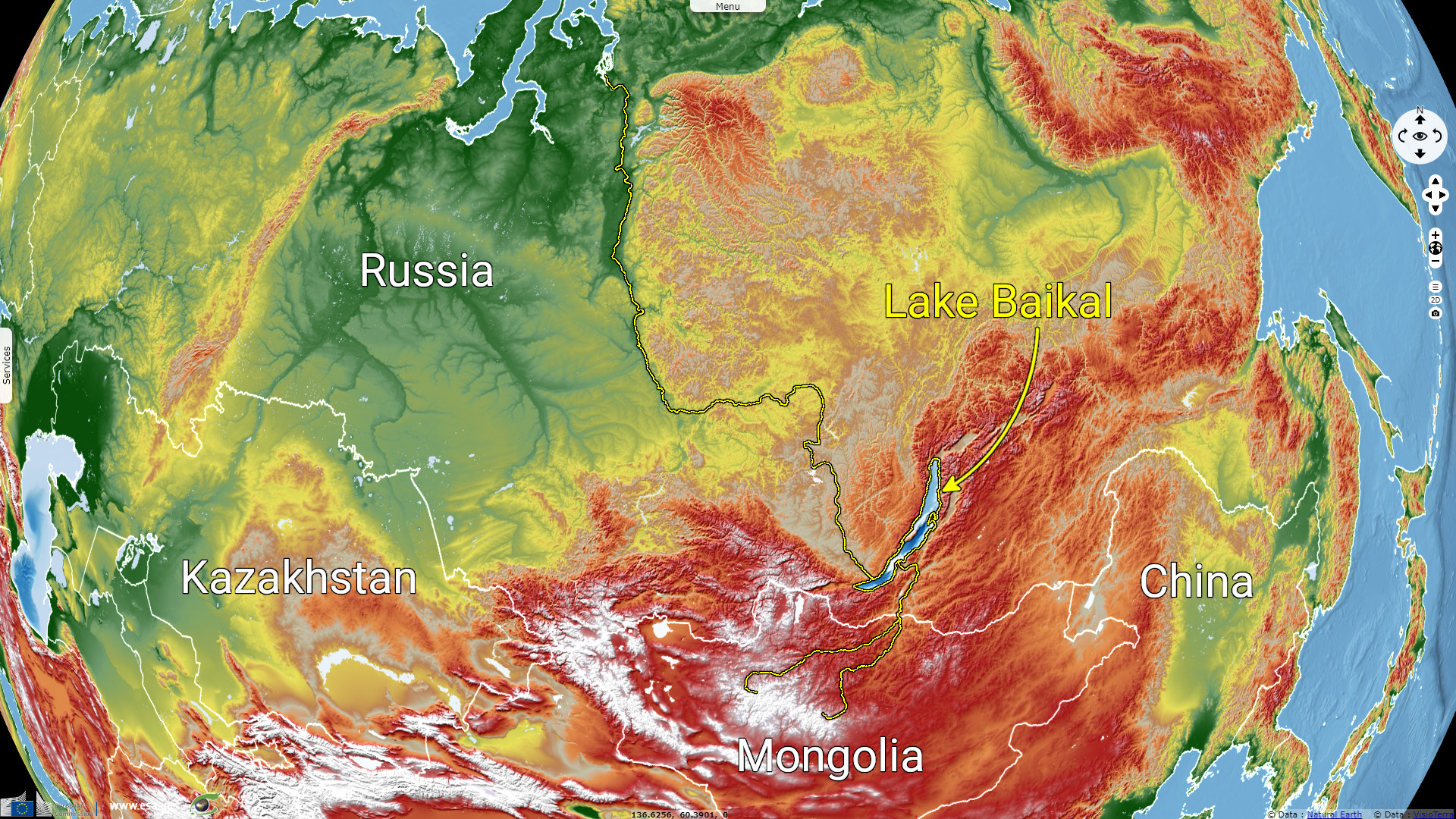
The Lake Baikal is a rift lake located in Russia at 455m height, between the Irkutsk Oblast and the Republic of Buryatia.
The Lake Baikal is more than 600 km long and its width exceeds 70km in places. The surface is around 31 722 km² which made the lake larger than Belgium. It is one of the largest lake behind the Lake Tanganyika. It is also the deepest lake, with a average depth of -745 m and a max depth of -1642 m.
Its surface and its depth made it "the world's largest freshwater lake by volume, containing 23 615 km³ of water". This correspond to more than 20% of the world's fresh surface water which is greater than the water contained by all the North American Great Lakes combined (Wikipedia).
Its surface and its depth made it "the world's largest freshwater lake by volume, containing 23 615 km³ of water". This correspond to more than 20% of the world's fresh surface water which is greater than the water contained by all the North American Great Lakes combined (Wikipedia).
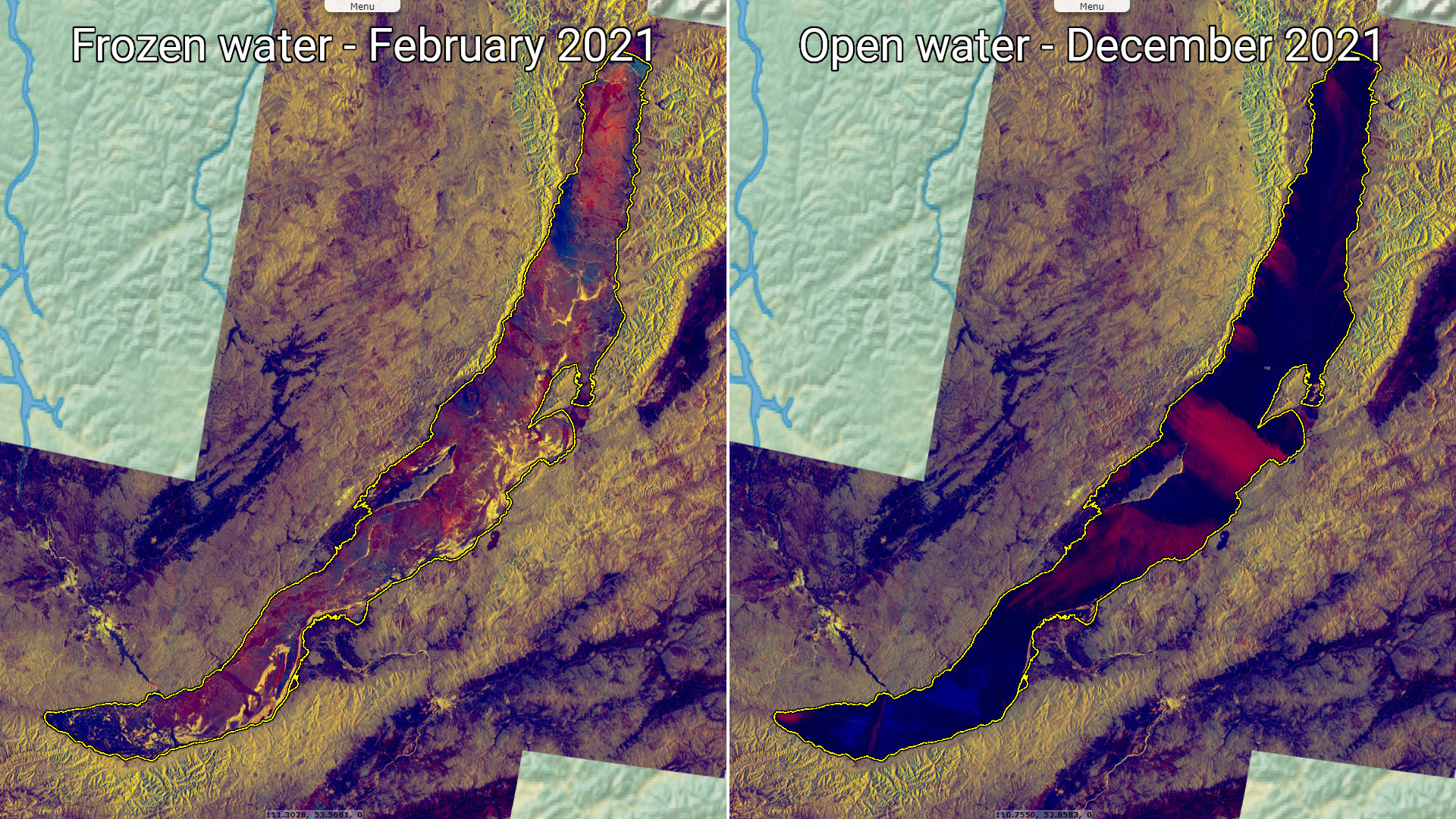
"In Lake Baikal, the water temperature varies significantly depending on location, depth, and time of the year. During the winter and spring, the surface freezes for about 4–5 months; from early January to early May–June (latest in the north), the lake surface is covered in ice. On average, the ice reaches a thickness of 0.5 to 1.4 m, but in some places it can be more than 2 m."
"After the surface ice breaks up, the surface water is slowly warmed up by the sun, and in May–June, the upper 300 m or so becomes homothermic (same temperature throughout) at around 4°C because of water mixing. The sun continues to heat up the surface layer, and at the peak in August can reach up to about 16°C in the main sections and 20–24°C in shallow bays in the southern half of the lake. During this time, the pattern is inverted compared to the winter and spring, as the water temperature falls with increasing depth. As the autumn begins, the surface temperature falls again and a second homothermic period at around 4°C of the upper circa 300 m occurs in October–November. In the deepest parts of the lake, from about 300 m, the temperature is stable at 3.1–3.4°C with only minor annual variations." (Source: Wikipedia).
The radar view shown here above right is one of the last available on this area. Since the failure of Sentinel-1B, there has been no further radar acquisition over Lake Baikal.
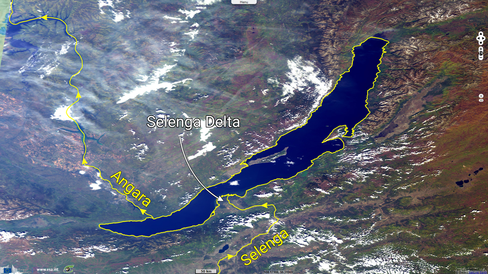
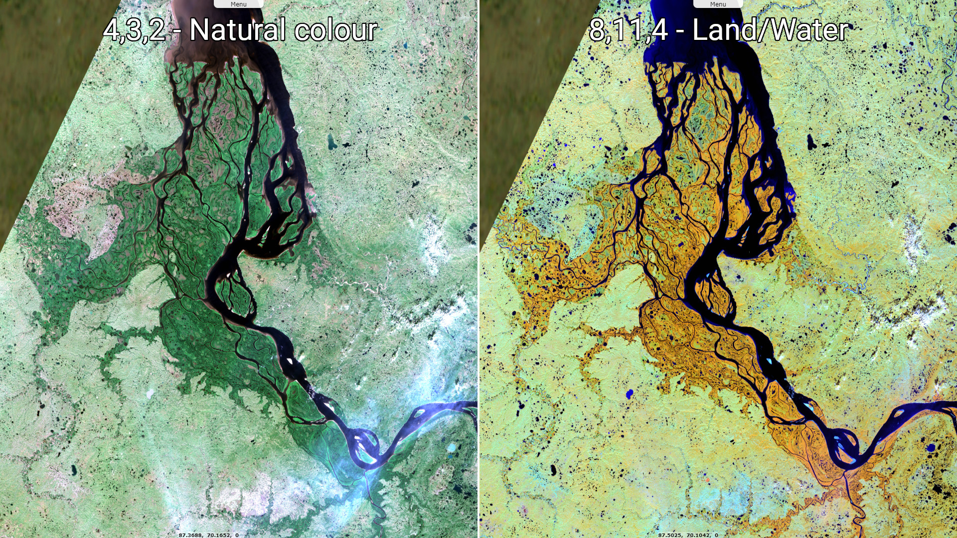
The Selenga river (also called Selenge) is the major tributary to the Lake Baikal. The origin of the river is in Mongolia, with the Ider river and take the 'Selenga' name at the confluence with the Delgermörön river. The Orkhon river joins the Selenga before draining into the Lake Baikal. The Selenga river "flows for 992-1024 kilometers" which "makes up the most distant headwaters of the Yenisey-Anaga river system".
"Carrying 935 cubic metres per second of water into Lake Baikal, it makes up almost half of the riverine inflow into the lake, and forms a wide delta of 680 square kilometres when it reaches the lake." (Source Wikipedia).
"Carrying 935 cubic metres per second of water into Lake Baikal, it makes up almost half of the riverine inflow into the lake, and forms a wide delta of 680 square kilometres when it reaches the lake." (Source Wikipedia).
Angara river is the outflow of Lake Baikal. It is "a major river in Siberia, which traces a course through Russia's Irkutsk Oblast and Krasnoyarsk Krai". It is 1849 km long and drains into the Yenisey river. Four dams has been installed to exploit the Angara river with a total installed capacity around 12 GW.
The Yenisey river drains into the Kara Sea through the Yenisey Gulf. The Yenisey river system is the fifth longest one and the largest to drain into the Arctic Ocean (Source Wikipedia). The Yenisey Gulf is part of the Great Arctic State Nature Reserve, the largest nature reserve of Russia (Source Wikipedia).
The Yenisey river drains into the Kara Sea through the Yenisey Gulf. The Yenisey river system is the fifth longest one and the largest to drain into the Arctic Ocean (Source Wikipedia). The Yenisey Gulf is part of the Great Arctic State Nature Reserve, the largest nature reserve of Russia (Source Wikipedia).
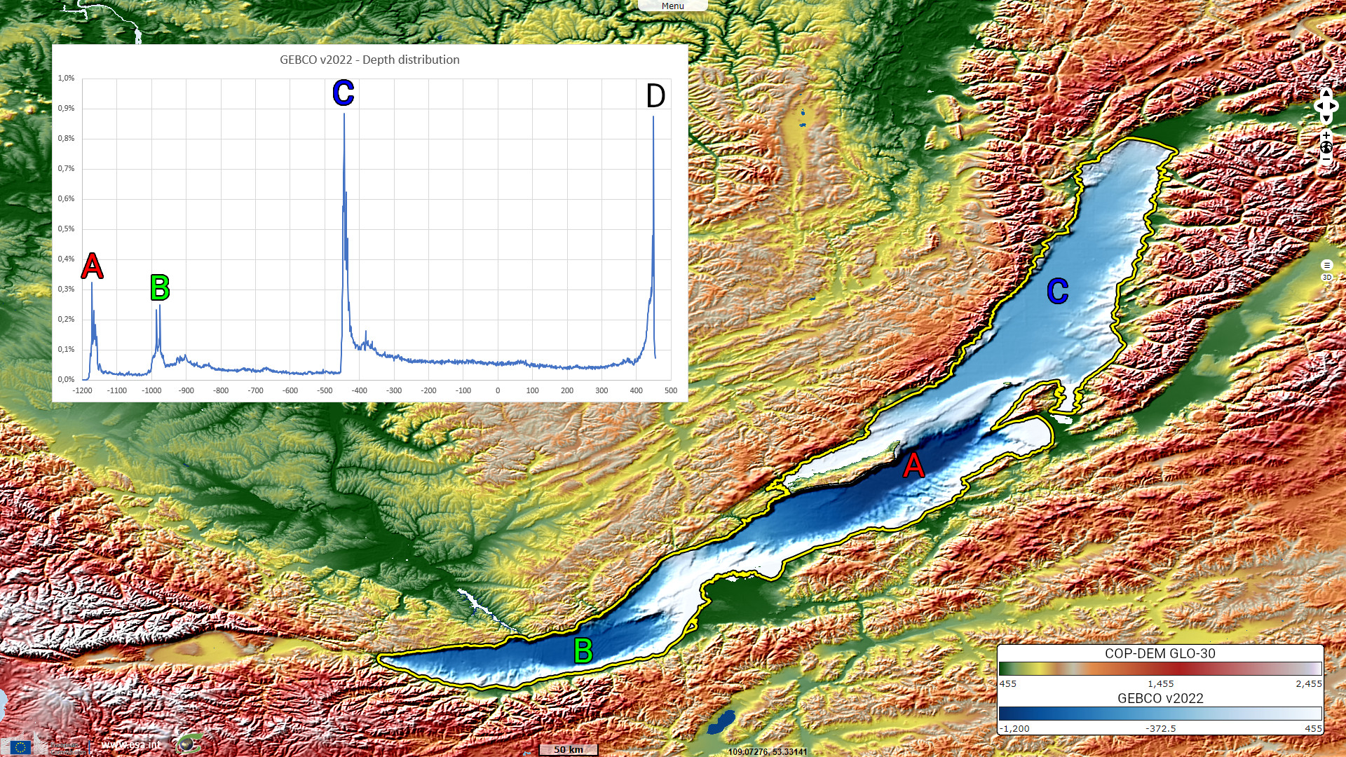
"Lake Baikal is in a rift valley, created by the Baikal Rift Zone, where the Earth's crust is slowly pulling apart. [...] The bottom of the lake is 1186.5 m below sea level, but below this lies some 7 km of sediment, placing the rift floor some 8–11 km below the surface, the deepest continental rift on Earth." "The lake is divided into three basins: North, Central, and South, with depths about 900 m, 1600 m, and 1400 m, respectively. [...] The North and Central basins are separated by Academician Ridge, while the area around the Selenga Delta and the Buguldeika Saddle separates the Central and South basins." (Source Wikipedia).
The graph shown in Fig. 6 display the depths distribution based on the GEBCO data (v2022). The depths values given for A, B and C are relative to the WGS84 ellipsoid which imply to take into account the lake height (approx 450 m) to retrieve the real lake depth. The D abacus correspond to the shoreline of the lake.
The graph shown in Fig. 6 display the depths distribution based on the GEBCO data (v2022). The depths values given for A, B and C are relative to the WGS84 ellipsoid which imply to take into account the lake height (approx 450 m) to retrieve the real lake depth. The D abacus correspond to the shoreline of the lake.
The views expressed herein can in no way be taken to reflect the official opinion of the European Space Agency or the European Union.
Contains modified Copernicus Sentinel data 2026, processed by VisioTerra.
Contains modified Copernicus Sentinel data 2026, processed by VisioTerra.
| More on European Commission space: |  |
 |
 |
||||
| More on ESA: | |
|
|
S-1 website | S-2 website | S-3 website | |
| More on Copernicus program: | |
|
|
Scihub portal | Cophub portal | Inthub portal | Colhub portal |
| More on VisioTerra: | |
|
|
Sentinel Vision Portal | Envisat+ERS portal | Swarm+GOCE portal | CryoSat portal |