Geology in the Afar
Sentinel-3 OLCI FR acquired on 23 November 2016 at 06:56:07 UTC
Sentinel-1 CSAR IW acquired on 03 July 2017 from 03:07:29 to 03:07:54 UTC
Sentinel-2 MSI acquired on 16 September 2017 at 07:52:11 UTC
Sentinel-2 MSI acquired on 26 September 2017 at 07:36:41 UTC
Sentinel-2 MSI acquired on 21 January 2018 at 07:42:31 UTC
Sentinel-1 CSAR IW acquired on 03 July 2017 from 03:07:29 to 03:07:54 UTC
Sentinel-2 MSI acquired on 16 September 2017 at 07:52:11 UTC
Sentinel-2 MSI acquired on 26 September 2017 at 07:36:41 UTC
Sentinel-2 MSI acquired on 21 January 2018 at 07:42:31 UTC
Keyword(s): Land, geology, continental rift, plates, fault, mountains, oceanic ridge, tilted blocks, volcano, Afar depression triangle, Danakil, Ethiopia, Somalia, Eritrea, Djibouti, East African Rift, Gulf of Aden, Arabia, Red Sea
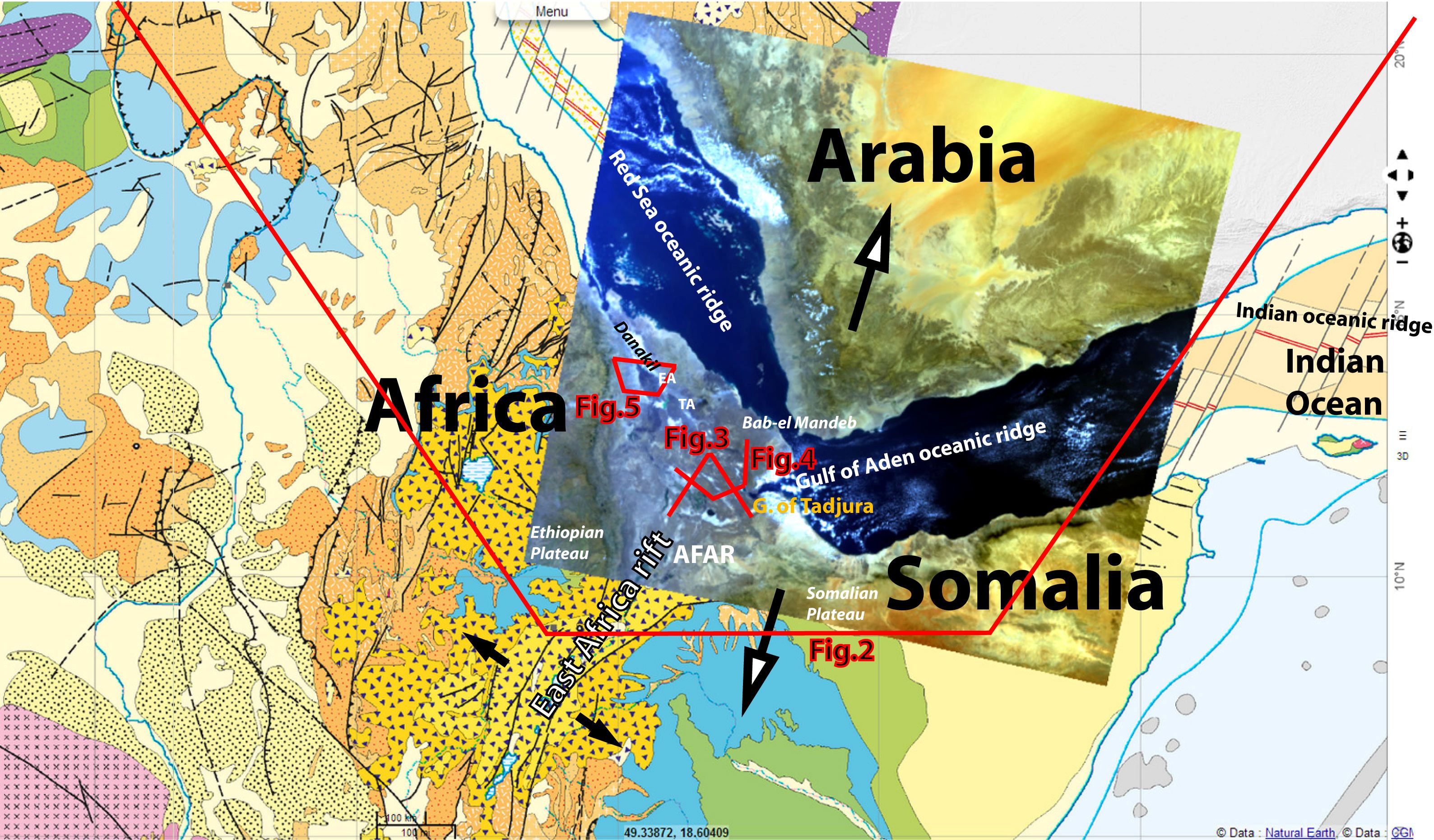
Pr. Jean Chorowicz, emeritus Professor at Sorbonne University described the area: "The Sentinel-3A OLCI/FR scene shows the Afar depression triangle in Africa, separated from the Arabia continent by the Red Sea in the NW and the Gulf of Aden in the NE. In the southern corner it links to the Main Ethiopian Rift (MER) that belongs to the East African Rift System (Fig.1).
The Afar triangle is a low-lying region (-127 m in the Danakil depression) floored by Plio-Quaternary basalts belonging to oceanic or thin continental lithosphere. It is bounded by continental escarpments of the Ethiopian Plateau in the west and the Somalian Plateau in the southeast.
It is the present-day rift-rift-rift triple junction of three divergent plates (see arrows: NNW-SSW divergence of Arabia and Africa-Somalia, NW-SE divergence of Africa and Somalia).
- The Gulf of Aden oceanic ridge (spreading rate 13 mm per year) forms the boundary between the Arabia and Somalia plates. It is the western segment of the major Indian Ocean ridge, penetrating and ending into the Gulf of Tadjura near the southeastern corner of the Afar triangle.
- The northwestern corner is related to the Red Sea oceanic ridge (spreading rate 12 mm per year) that forms the boundary between the Arabia and Africa plates and ends before reaching the Bab-el Mandeb detroit.
- The third corner, in the south, connects with the East African continental rift (spreading rate 5 mm per year) separating the Somalia new plate from main Africa (Nubia plate)"
Pr. Jean Chorowicz comments:
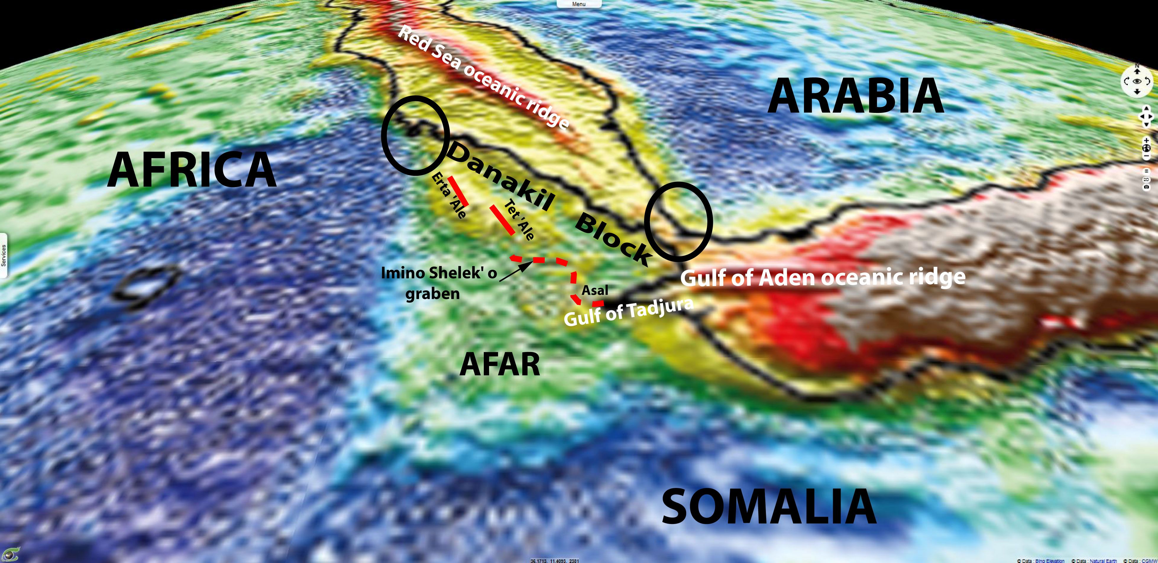
"The Bouguer anomaly map (red, positive anomalies = dense oceanic lithosphere; blue, negative anomalies = low density continental lithosphere) shows the Gulf of Aden oceanic ridge westward ending in the Gulf of Tadjura. In the Red Sea, another oceanic ridge (in red) ends southeastward, west of the Bab El Manded Detroit. The Afar triangle is characterized in the map by yellow and green colours respectively related to mean-high and low density basement, meaning thin continental lithosphere. Circles are extremities of the Danakil block.
The Gulf of Tadjura (Fig.2) is a rifted zone that continues to the NW with the Asal salted lake and then with a fault zone that seems to connect with a rift (Imino Shelek’o graben). Further NW, seemingly along the same line, two elongate volcanic massifs (Erta ’Ale and Tat ’Ale) form ‘en échelon’ ranges. On the Bouguer map this line is superimposed to a yellow coloured elongate zone representing a thin continental lithospheric which, in turn is side by side to the east with an elongate, green coloured, thicker continental lithosphere called Danakil block. The inferred structural line (red broken line) represents the termination of the Indian Ocean-Gulf of Aden oceanic ridge, ending into an extending thin continental lithosphere.
Similarly, the Red Sea oceanic ridge ends into extending thin continental lithosphere of the Bab El Mandeb Detroit and related islands of the Hanish archipelago. The Danakil block lays in between, almost still in contact with continents at its NW (Africa) and SE extremities (Arabia) see circles and is consequently considered to have counterclockwisely rotated in order to accommodate this geometry while Arabia drifted to the NNE relatively to Africa (“biélette” Danakil concept)."
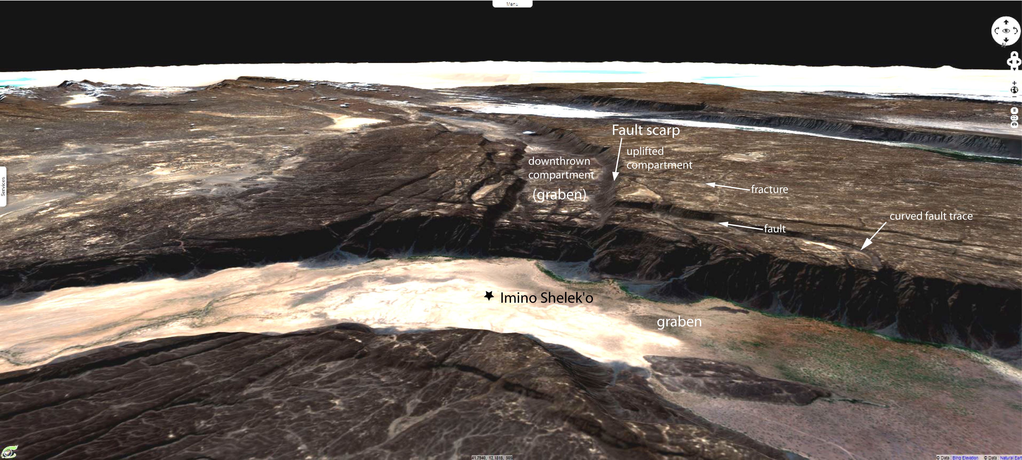
Pr. Chorowicz added: "In the Afar, the tectonics is characterized by (fig.3):
- the occurrence of downthrown graben (rift) structures bounded by extension faults
- tilted blocks.
Oblique view to NW. ISG: Imino Shelek’o graben. F: fault scarp. T: dip of tilted block. +: horizontal dip. V: volcano.
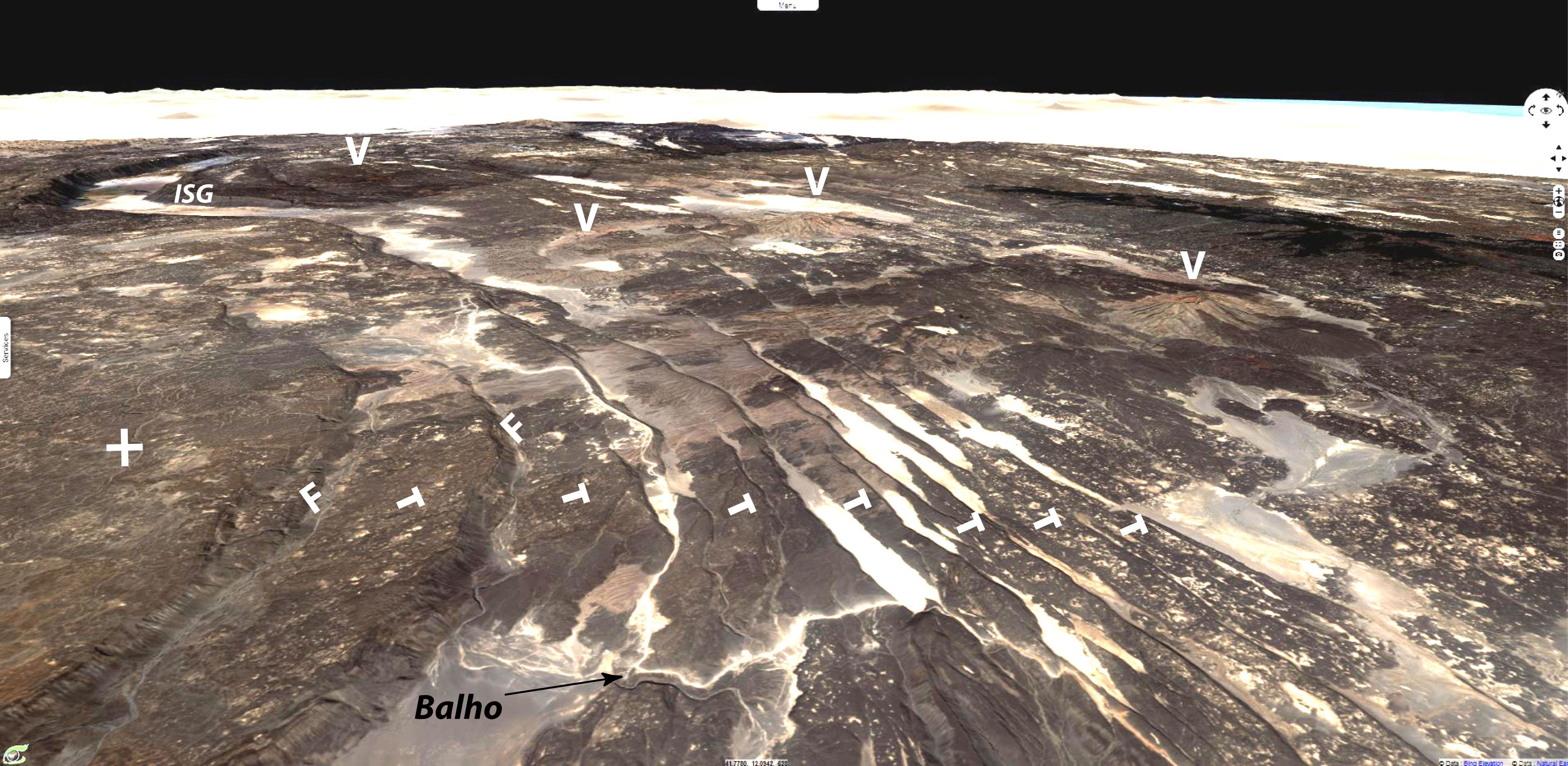
The Imino Shelek’o graben (ISG) eastward ends and then in the Balho area is in line with a series of sub-parallel extensional faults forming N110° striking lines at the boundary of elongate tectonic blocks.
All the blocks are tilted to the south-southwest (T). The fault scarps uniformly face the north-northeast. Some show a well exposed fault scarp (F) dipping to the north-northeast at an angle of #70°. This is a landscape of tilted blocks bounded by normal faults, typical of extensional regions. This geometry implies that the faults in cross-section progressively curve in depth in order to permit the block rotation relative to a horizontal axis: their dip should decrease with depth. Such curved faults responsible for block tilting are named ‘listric faults’.
By places, salted sediments (light colours) are deposited in lower strands of the tilted blocks. A few volcanoes (V) are topping the faults but their history is complex in detail for some normal faults affect the volcanoes.
End of the Gulf of Aden oceanic ridge at NW tip of the Erta Ale volcanic belt - V: volcano.
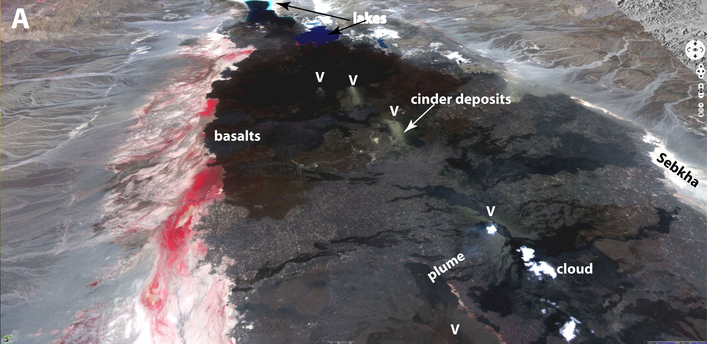
“A - The Sentinel-2 MSI image shows the Erta ‘Ale elongate Quaternary volcanic massif made of dark volcanics, lying in the middle of a basin. The rocks are mostly black basalts, associated with lighter coloured trachytes and rhyolites.
Volcanoes (V) are mostly aligned NW-SE along the crest of the belt and some have an elongate shape in plan view, with NW-SE trending main axis. White clouds may hide the summit of some volcanoes. An active volcano (Hayli Gubbi) shows a faint bluish plume. Two volcanoes (Borale Ale, Alu) are partly covered at top by grayish cinder deposits”, wrote Pr. Jean Chorowicz.
“Water is pouring out along the southwestern border of the lava flows, as shown by the vegetation (in red). Along the northeastern border there are several salted lakes (in blue) and sebkhas (white) but no vegetation, which means that the water there is salted. In the 12,11,2 composition of animation, small red spots are hot melted magma of active volcanism.”
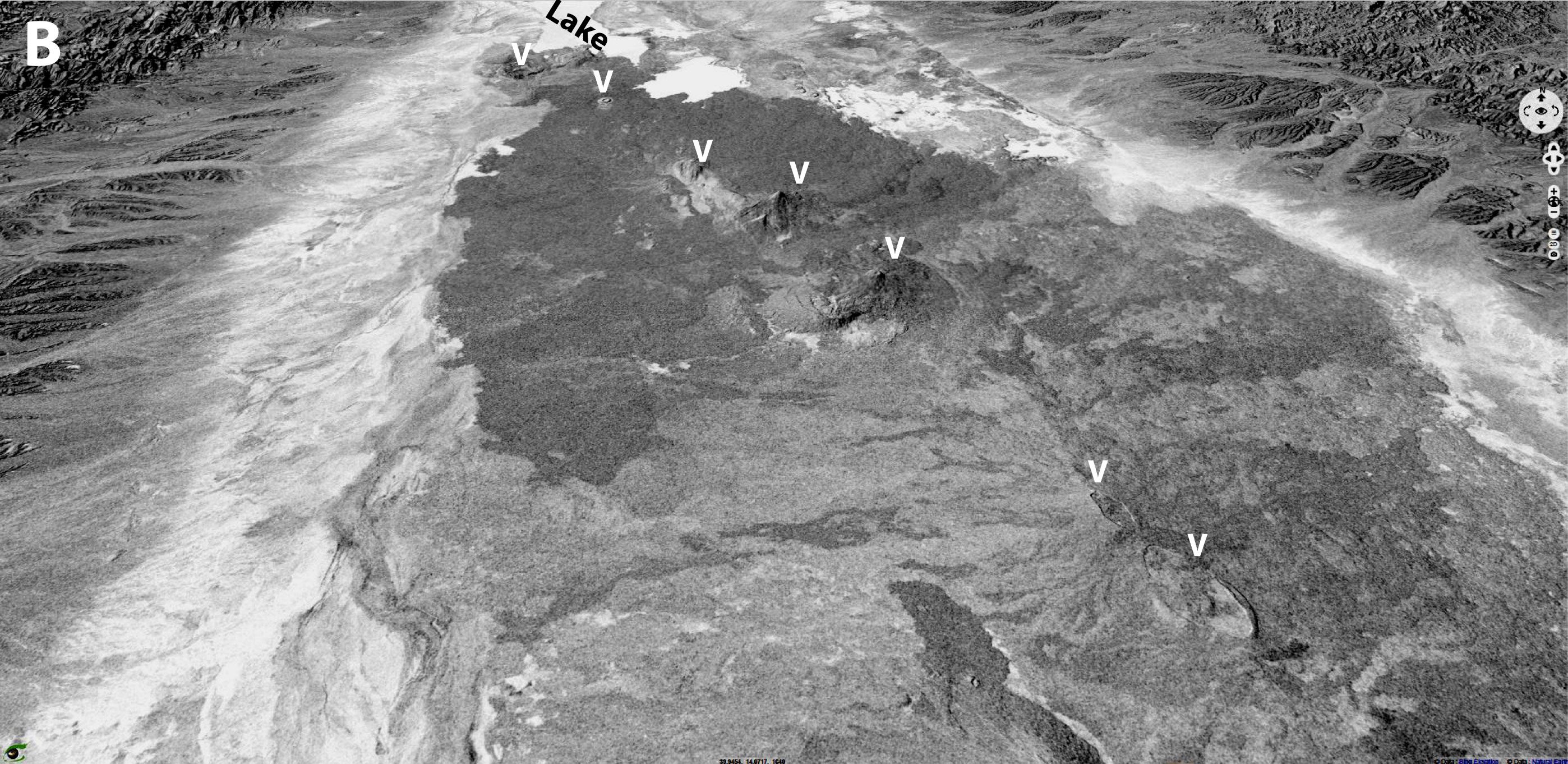
“B - Radar images they are sensitive to the relief, roughness and moisture of the land surfaces but do not sense spectral signatures and clouds. The image displays distinct volcano shapes as well as texture and grey tones details in the lava flows that cannot be well observed in the optical image. Lakes are white in this negative display (smooth surfaces). Radar and MSI imageries are complementary.”, Pr. Chorowicz concluded.
The views expressed herein can in no way be taken to reflect the official opinion of the European Space Agency or the European Union.
Contains modified Copernicus Sentinel data 2026, processed by VisioTerra.
Contains modified Copernicus Sentinel data 2026, processed by VisioTerra.
| More on European Commission space: |  |
 |
 |
||||
| More on ESA: | |
|
|
S-1 website | S-2 website | S-3 website | |
| More on Copernicus program: | |
|
|
Scihub portal | Cophub portal | Inthub portal | Colhub portal |
| More on VisioTerra: | |
|
|
Sentinel Vision Portal | Envisat+ERS portal | Swarm+GOCE portal | CryoSat portal |