Geology in Zagros as an open book
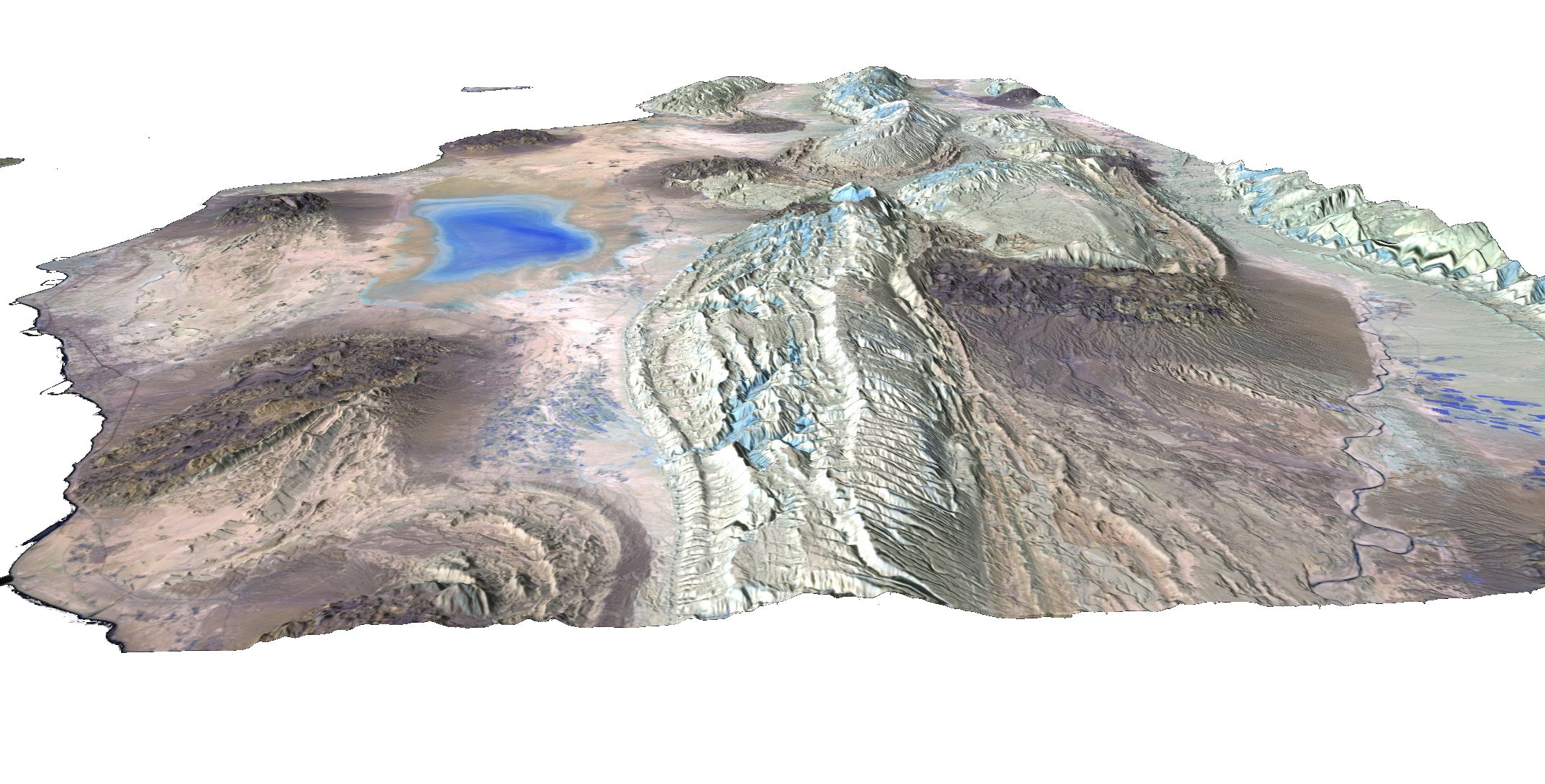
Pr. Jean Chorowicz said: "Oblique view to the west along the Persian Gulf. Elevation factor 2. Colour composite image only with the infrared bands (SWIR B12 in red, SWIR B11 in green, NIR B8A in blue) for a lesser effect of the atmosphere and for the vegetation in green.
This image shows the most characteristic features in the region:
The area is divided into:
The core of the large Kuh-E Champen anticline fold comprises middle Miocene alternation of 'hard' and 'soft' sediments cut by tensional faults forming small graben (troughs) in extrado of competent carbonates. The northern rim exposes a unit of 'hard' late Miocene carbonates which top boundary forms structural surfaces cut by parallel deep ravines. Landslides can be observed at the foot. There are also a number of smaller triangular structural surfaces forming 'chevrons' ('iron flats'). Observations can be used for education training in geology and geomorphology or for research, e.g., comparison of the various diapir structures."
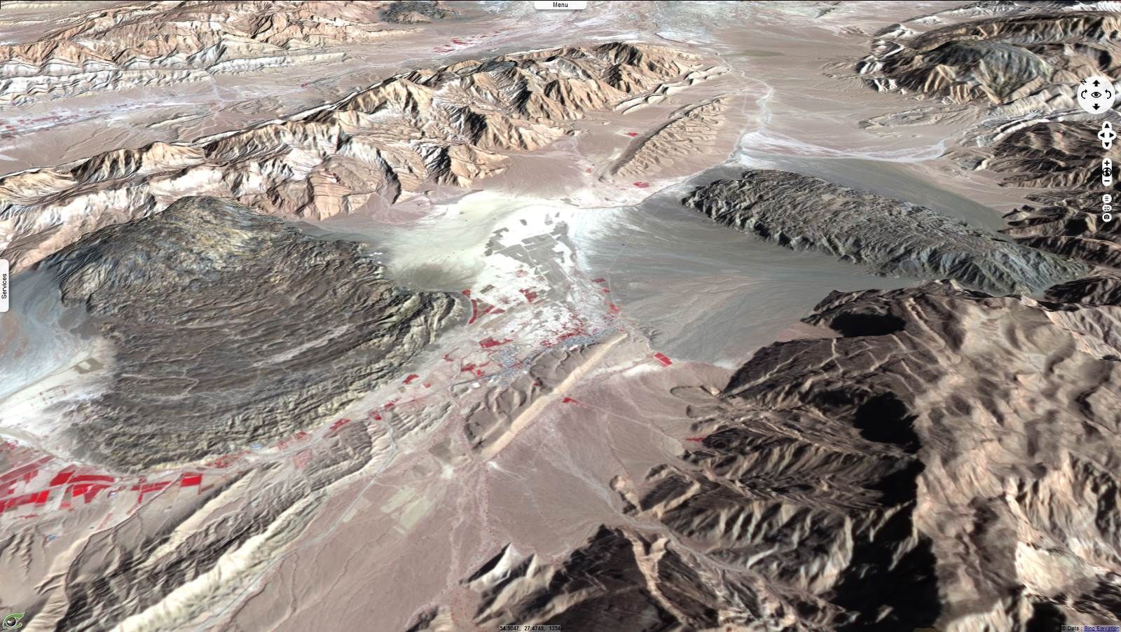
Pr. Jean Chorowicz said: "Salt diapirs in the area are one of the geological wonders of the world. This E-directed oblique view shows two active diapir features (namakier, river of salt), each with an elongate salt neck at top supposed to be located right above a hidden open fracture. Salt has moved down from the neck to form lobe-shaped salt flows. Wave texture suggest flow over Quaternary sediments, according to the maximum down-slope line of the fold sides away from anticlines. Other diapirs are visible nearby in the region. The diapir consists of a coloured mélange of salt, anhydrite, dolomite, shale, siltstone and sandstone, including fragments of a number of other rocks.
Diapir shapes and genesis is a preferred subject of research among geologists who discuss about their structures and genesis. These salt intrusives have close relationships with oil trapps. They are ascending from deep seated (7 – 9 km), thick (more than 1 km) salt sedimentary layers. This halokinesis process has similarities with the emplacement of hot volcanic rocks forming peaks and flows and with mud volcanoes."
Contains modified Copernicus Sentinel data 2026, processed by VisioTerra.
| More on European Commission space: |  |
 |
 |
||||
| More on ESA: | |
|
|
S-1 website | S-2 website | S-3 website | |
| More on Copernicus program: | |
|
|
Scihub portal | Cophub portal | Inthub portal | Colhub portal |
| More on VisioTerra: | |
|
|
Sentinel Vision Portal | Envisat+ERS portal | Swarm+GOCE portal | CryoSat portal |
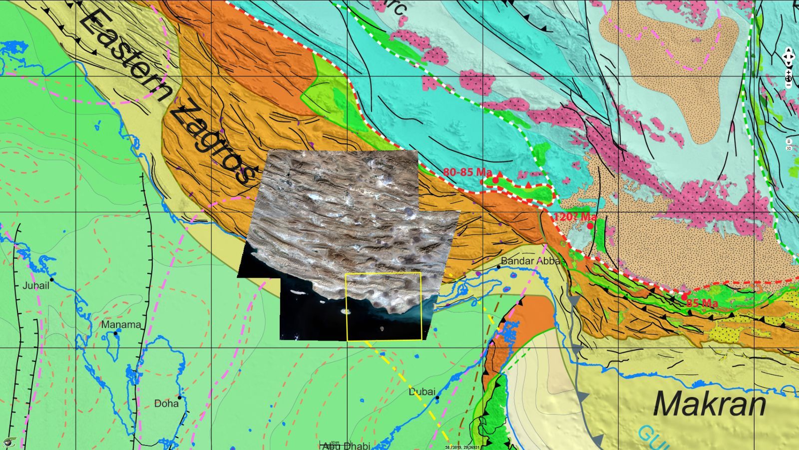
Pr. Jean Chorowicz, emeritus Professor of University Paris 6 said: "The Sentinel-2 scene acquired over Iran on 7 January 2017 is divided into 100x100 km tiles but some are not displayed. The colour composite image in 'true colours' - B4 in red, B3 in green, B2 in blue - shows here in the context of the “Structural Map of the Arabian Plate and Surrounding Areas” (distributed by the Commission for the Geological Map of the World, CGMW, see legend and covers a part of the Fars area in the Zagros (Iran) along the northern shore of the Persian Gulf, one of the oldest studied and exploited petroleum provinces of the world.
It belongs to a larger south-west-verging Bitlis active orogen formed by the collision of continental fragments from the former Gondwana plate. This former passive margin of the Arabian continent was separated in the early Mesozoic from other Gondwana continental fragments by the opening of the Neo-Tethys paleo-ocean. This ocean was finally closed during the late Eocene while collision started and is still active until the present time. This major suture contact is out of the scene but underlined by a white-and-red dash line on the map.
The yellow frame included in the image matches the views of geologic and geomorphologic evidences of the next figure below."